Choban-kule - a medieval tower in Crimea. Choban-Kule - ruins of a castle on a picturesque cape near Sudak Choban Kule Crimea
5 km from the village of Morskoye, in the area of the village. Privetnoye, Cape Agira is located, on which the medieval tower “Shepherd-Kule” of the 14th – 15th centuries is located, which means “Shepherd’s Tower”. It is surrounded by the remains of ancient buildings and defensive walls.
The tower is made of fairly massive stones and pieces of rock. The walls reach a thickness of 2–3 meters. Its height is now approximately 9–10 meters. The entrance to the tower is located on the southwestern side and is heavily damaged.
The upper part of the tower was also destroyed, probably mainly due to tourists.
Inside the tower, in the wall, there is a fairly deep niche with an opening to the outside, the purpose of which can be very diverse. The fireplace and water pools located in the basement have been preserved.
On the eastern side of the tower, the remains of defensive walls are still visible; according to some sources, there was a temple not far from the tower. Massive ruins at the foot of the tower bear the outlines of some buildings.
If you notice an inaccuracy or the data is out of date, please make corrections, we will be grateful. Let's create the best encyclopedia about Crimea together!
5 km from the village of Morskoye, in the area of the village. Privetnoye, Cape Agira is located, on which the medieval tower “Shepherd-Kule” of the 14th – 15th centuries is located, which means “Shepherd’s Tower”. It is surrounded by the remains of ancient buildings and defensive walls. The tower is made of fairly massive stones and pieces of rock. The walls reach a thickness of 2–3 meters. Its height is now approximately 9–10 meters. The entrance to the tower is located on the southwestern side and is heavily damaged. The upper part of the tower was also destroyed, probably mainly due to tourists. Inside the tower, in the wall, there is a fairly deep niche with an opening to the outside, the purpose of which can be very diverse. The fireplace and water pools located in the basement have been preserved. On the eastern side of the tower, the remains of defensive walls are still visible; according to some sources, there was a temple not far from the tower. Massive ruins at the foot of the tower bear the outlines of some buildings. Save changesFour kilometers southwest of the village of Morskoye there is a steep, steep Cape Agir. Several campsites and tent cities are located at the foot. The top of the cape is crowned by the ruins of the medieval Shepherd's Tower of Choban-Kule. Some sources claim that the first fortifications were built on the cape by the Byzantines two thousand years ago. However, first things first.
Photos from users:


Useful information:
- The tower is clearly visible from Cape Ai-Foka, the village of Morskoye and coastal campsites near Privetnoye. The height of the remains is 9-10 meters.
- Researchers believe that the construction of the castle took place in the middle of the 15th century.
Medieval manners and customs
The tower became famous during the time of the Genoese owners, Papa and the three brothers di Guasco (their names were Andreollo, Dimitri, Teodoro). In the middle of the 15th century, they captured the surrounding villages of Tassili and Gromovka and established extremely cruel orders. To intimidate the residents, a gallows was erected in the center of Privetnoye, and a pillory was placed on the border of the property. Even the Sudak consul could not calm the brothers down. The confrontation was resolved in hot July 1475: the coast was captured by the Turks and the cruelty of the previous owners was quickly forgotten.
Exterior view of the structure in the Middle Ages
The castle had a square shape and was small in area. In the center stood the donjon, the tower in which the di Guasco brothers lived. It is built from massive boulders brought from the seashore and pieces of rock. Along the outer perimeter were fortress walls with loophole towers in the corners. The thickness of the walls ranged from 2 to 4 meters; outbuildings made of clay were molded to them from the inside. In the western part there was a small temple. From the castle an underground chord led to the foot of Cape Agir.
Video review of Choban kule
Choban-Kule Tower today
Now you can get inside the tower from the southwest side. The ground floor, first and partly second floor are well preserved. Inside you can see a niche in the wall (archaeologists speculate about its purpose). In the basement there is a collection pool fresh water and utility rooms. The blank walls of the first floor suggest that there were storage rooms here. The living rooms were higher; on the second floor there was a well-preserved fireplace and embrasure.

What to visit in the area
There is a branch of the museum in the village of Morskoye. Authentic documents are kept here that shed light on the history of the fortress. The correspondence of the Sudak consul Soldai, the venerable Cristoforo di Negro, with the metropolis is interesting. It contains complaints about the scandalous temper and tyranny of the di Guasco brothers, their unwillingness to obey the Sudak community. From this meager information one can imagine some of the events of that harsh era.
You can stay overnight in neighboring villages, or put up a tent in the Privetnoye camping site or the Livecamp tent camp.
How to get to Choban-Kule and Cape Agir
On regular bus Alushta-Sudak you need to get to the stop. It is located between the villages of Privetnoye and Morskoye. Then you will have to walk a couple of kilometers along a dirt road to Cape Agir. The tower will be visible from afar.
With your own car, the route is similar, only you can drive almost all the way to the tower.
Choban-Kule on the map of Crimea
GPS Coordinates: 44°48’40″N 34°44’45″E Latitude/Longitude
What name the castle and the surrounding area had is unknown. Only the name in Tatar is known. Chaban-Kale is translated from the Tatar language as “shepherd’s fortress” or as Chaban-Kule “shepherd’s tower”.
Geography
Shepherd-Kale is located near the village of Morskoye, near Sudak. In the same area there was the Chaban-Kale-Chokrak spring, from which the Chaban-Kale-Yozen stream flowed further.
Archeology
In the area of the village of Morskoye (where Chaban-Kale is also located), pottery from the 8th-9th centuries was discovered. The ovens were cut into a rising slope and made of mud brick. They produced mainly round-bottomed egg-shaped amphorae, flat-bottomed vessels, round flat flasks and pithos for sale throughout the Crimean coast, where pottery was required.
From the 15th century castle The Guasco brothers were left with only a round lookout (donjon) and at its foot the remains of walls. In addition, parts of residential buildings were discovered that constituted formerly a village at the lock.
Notes
Literature
- Andreev A. R. History of Crimea: Brief description past of the Crimean peninsula. - M.: Interregional Center for Industry Informatics of Gosatomnadzor of Russia, 1997. - 97 p.
- Keppen P. About the antiquities of the southern coast of Crimea and the Tauride Mountains. - St. Petersburg: Imperial Academy of Sciences, 1837. - 409 p.
- Myts V. L., Kirilko V. P., Lysenko A. V., Tatarintsev S. V., Teslenko I. B. Research of the medieval fortification of Chaban-Kule // Archaeological research in Crimea. 1994. - 1997. - No. 1. - P. 200-208.
- Shilik K.K. On magnetic prospecting of pottery kilns near Chaban-Kule // Brief communications of the Institute of Archeology. - 1974. - Issue. 140. - pp. 115-120.
- Yakobson A. L. Medieval Crimea: Essays on history and history of material culture. - M.-L.: Nauka, 1964. - 232 p.
On the way, we saw a marked landmark in the navigator - the Choban-kule tower. We read that they open from it gorgeous views, kind of it observation deck. We decided to see this for ourselves and hit the road.
Choban-Kule. Historical information.
Choban-Kule is translated as “shepherd’s tower”. There is a variant of the name Choban-Kale, which means shepherd's fortress. It is generally accepted that the Choban-Kule tower belongs to a complex of towers left over from the Tasili fortress, which belonged to the Genoese feudal lords - Guasco's brothers. The tower is built from massive stones and rock pieces. The thickness of the walls reaches three meters. The height today is about ten meters.
In the nineteenth century, a large pottery center was located near Choban-Kule. This is evidenced by large number fragments of burnt clay and ceramics remaining near the kilns. The manufactured dishes were distributed throughout Taurica and beyond.
After the Tatar Khan recognized himself as a vassal of the Turkish Sultan, the right of the Genoese granted by the Khan of the Golden Horde Tokhtamysh ceased to apply. The lands and wealth of the Genoese in Crimea were declared the property of the Sultan. The Guasco brothers decided to fight, hoping for the height of the walls of their fortress, but after a long siege they were forced to surrender.
Choban-Kule. Review.
On the road from the village of Morskoye, we turned onto a country road towards the sea. We drove past an abandoned well. We saw a small forest where people were standing with tents. We added it to the navigator as a camping spot. We drove a little further to quiet place We parked the car and prepared to climb Choban-Kul. A horse blocked our way:
Then we saw another one:

Here they are together:

After talking with the animals we set off to climb. It leads to Choban-Kula and is completely good road, the downside is that it makes the straight path longer. We decided to climb straight, the landmark was the Choban-Kule tower itself. It was barely visible from below. The path was uphill, it’s good that we rested the previous two days. Don’t forget to turn around to admire the views:

We made it through the journey with only one break. Although the height is not very great, there was still joy from achieving the goal, here is Choban-Kule in all its glory:

According to Slavic custom, everyone wants to leave a memory of themselves and write their name or the name of the city on an ancient building:

The views are truly amazing:


It's time to climb the tower itself:

Let's take a photo from another angle:

An interesting moment, being near Choban-Kule, the shepherd’s tower, we met a shepherd with a flock of sheep:

After exploring, we went downhill to the car.
Choban-Kule. Bottom line.
Our morning exercise in the form of climbing to the Choban-Kule tower has come to an end. The ascent will not be difficult and will not take time, but will give you pleasure. Moreover, it is located next to the highway. We recommend visiting. Meanwhile, we set course for what was waiting for us indescribable beauty mountain lake, surrounded by mountains and a hike through the gorge to the Arpatian waterfalls, this is what the next issue will be about! Thank you for your attention, see you soon! Don't forget to watch the video for a better idea and subscribe to channel if you haven't already done so:
History has preserved the true names of the owners of the castle, the date of construction and other points. The correspondence of the Sudak consul with the metropolis has also been preserved. From this correspondence we learn a lot about the history of these places, including events related to the owners of the castle, the Guasco brothers. These documents are kept in the museum in Morskoye.
According to some reports (also confirmed by local residents), there was a passage from the tower to the foot of the cape, which was blown up in the mid-twentieth century.
There was also an opinion that there was a military facility located here, as evidenced by powerful cables near the cape. In fact, these cables were used to secure a buoy, which was once torn off during a storm.
From Choban-Kule you can see Meganom, Chekan-Kaya, Ai-Foka on the left, and a ridge of beautiful mountain ranges ending with Ayu-Dag on the right. If you walk around the field at the foot of the cape, you can see a wine storage facility built at the beginning of the century.
The tower of the Choban-Kule castle depicted on the coat of arms of the village of Morskoye.
Surrounding area
Leaving the Alushta Valley and moving further east, we are already leaving the boundaries of the “officially recognized” South Bank Crimea. The landscape is changing mountain ranges Demerdzhi and Tyrke, the vast gloomy Karabi highlands move north of the highway, giving way to low foothill ridges and ridges, separated from each other by deep ravines - the beds of drying up watercourses. It is clearly no longer subtropical, the vegetation is becoming scarce, and evergreen Mediterranean species are disappearing. Settlements located much less frequently, between them there are several kilometers of completely pristine landscapes. Since ancient times, life here was tied to the valleys of the small rivers Ulu-Uzen, Kuru-Uzen, Kanaka and others.
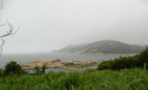
Circling through the hills, now approaching the sea, now moving away, the road even manages to get boring. Fifty kilometers from Alushta, having passed the turn to the village of Privetnoye (formerly Uskut) and not reaching 5 kilometers to the village of Morskoye (formerly Kapsikhor), we overcome another low pass and again turn towards the seashore. From here you can see the Tower Cape, also known as Agira and Choban-Kule. The ruins of an imposing round tower at its eastern end immediately attract attention. This is the Choban-Kule castle. Turning onto the dirt road leading to the sea, and then onto the path, it is not difficult to climb to the foot of the tower.
Description of the fortress
The fortification consisted of the castle itself - the donjon tower and the surrounding walls with corner towers and the adjacent lower courtyard extended to the southeast, also surrounded by a massive wall, but not so thoroughly built, on clay. The ground floor, first and partially second ground floors have been preserved from the monumental donjon. Now the height of the tower reaches nine meters, it must be assumed that it was at least three or four meters higher. In plan, it is rather ovoid than round; even more surprising is the variable thickness of its walls - from less than two meters in the south to more than four in the northeast. In the basement of the tower there was a water tank covered with vaults and a utility room. The walls of the first floor are completely blank; apparently, the room had a storage purpose. The remains of the entrance opening are noticeable only on the second floor; an embrasure and a fireplace have also been preserved here. The interfloor ceilings were made of wood, and the vault of the last floor, judging by the materials of the 19th century, had a domed ceiling, similar to that preserved in the donjon of the Chembalo fortress.
Donjon Choban-Kule was surrounded by a perimeter of fortress walls. Excavations fifteen years ago revealed the eastern curtain, two corner towers and partly the northern curtain of the walls. The round corner towers against the backdrop of the donjon do not give the impression of monumental buildings; their diameter did not even reach four meters. The defensive walls were also not particularly strong - one and a half meters. The corner turrets had firing loopholes with the possibility of firing along the walls. In general, the castle is being reconstructed as a square fortification with four towers in the corners and a massive donjon in the center of the fortress courtyard. Adjacent to the castle - the lord's home - was a lower courtyard, where the servants lived and outbuildings were located.
History of the fortress
According to the successfully complementary evidence of surviving documents and excavation materials, it is known that his life was short, maximum between 1460 and 1475. But thanks to the same documents, we can tell something about its owners. In the XIV-XV centuries, the Choban-Kule district was part of the Genoese possessions and was the western outskirts of the Sudak consulate. The old names of nearby villages are repeatedly mentioned in medieval documents Skuti - Uskut (now Privetnoye), Sili - Shelen (now Gromovka), Karpati - Arpat (now Zelenogorye), Volli (now Raven). The local settlement was known as Tassili.
Often, characters from Genoa appeared in the colony with, on the one hand, an active course of action, and on the other, a scandalous disposition. They continued to muddy the waters here too. On the eve of the Turkish invasion, the Sudak consulate became the scene of a rather vulgar conflict. Its details are known from surviving correspondence. A certain Di Guasco family entered into an open confrontation with the consul himself. Let us note that the consul of Soldai, the venerable Cristoforo di Negro, judging by the documents, appears as an example of the responsibility of an administrator and the valor of a knight, although somewhat boring in his complaints. Overall, he remains a very likeable character from that unsympathetic era.
It is likely that Antonio di Guasco Sr., the founder of the seigneury of Tassili, appeared here in the late 1450s. In any case, by 1474, those who had been wronged by him local residents They still remembered very well the times when there was no smell of a newly-made gentleman here. How he got control of this area remains an obscure question. He began to build the castle under the pretext of protection from the increasing attacks of Turkish pirates. According to the authorities, the fortress was also designed to restrain the rulers of Theodoro in their appetites for the outlying possessions of the Sudak consulate. In 1474, Antonio di Guasco appears as the head of a family clan with three adult sons - Andreolo, Teodoro and Demetrio.
So, daddy di Guasco and his three thugs openly encroached on the powers of the consul, put together a gang of about forty people, usurped the right of the judiciary, began to extract taxes and fines from the residents of the surrounding villages in their favor, and beat up the guards sent to admonish him by the consul of Sudak. By the way, the attitude towards the villagers of Di Guasco was not distinguished by their gentleness, and if they installed a gallows at the village of Scuti, then, presumably, it was not empty. It got to the point that the di Guascos burned down several sheepfolds of the mentioned Derbiberdi, the ruler of Alushta, a vassal of the Mangup princes, and this was already an interstate border incident with unpredictable consequences. More precisely, on the contrary, with very predictable ones: the victim hinted to the Genoese authorities that, of course, he would wait for compensation for losses, but if he didn’t wait, he would put it on the counter and figure it out in terms of concepts.
Going on their predatory forays, di Guasco did not even leave a guard at the castle, about which the Sudak consul wrote to the Kaffin consul di Cabella, complaining that he could not rein in these scoundrels and always felt the danger that the castle would be captured either by the Feodorites, or, God forbid , Turks.
At the same time, the owners of the castle, naturally, did not want to feed the soldiers whom he could send as a permanent garrison. Somehow the di Guascos took the government bombard, which was so necessary in Sudak itself, to their castle, and were in no hurry to return it. Added to this were the repeatedly documented facts of giving bribes to Sudak and Kaffa officials and constant intrigues against the consul himself. In general, the episodes of the case were enough for all four of them to get good terms with the confiscation of the castle. The most piquant thing is that the consul of Caffa took the side of di Guasco and the consul of Sudak remained unsatisfied with his rights.
It is assumed that professional fortification engineer Antonio de Bonino, sent from Genoa to inspect local fortifications, could have participated in the construction of the castle in 1473, or at least given valuable recommendations that helped improve its defensive qualities. Researchers believe that during the construction of Choban-Kule, resistance to artillery fire was already taken into account, and the castle itself was clearly adapted to the use of early types of firearms. This is evidenced by the plan of the castle itself, which is very typical of European fortress construction in the 15th–16th centuries. The walls of the donjon are significantly thickened in the direction of possible shelling. The corner towers were probably made squat, flush with the outer walls. The durability of the structures was facilitated by the rocky foundation of the fortress site. Its outer walls, almost a quarter of the height, are facing a rock monolith. They tried to bring the combat movement along the wall at the same level and achieve safety of movement along the entire perimeter of the fortifications. The battle loopholes could well have been used for firing from the sarbatana - a primitive type of hand-held firearm. During excavations, crossbow arrow tips, metal armor plates, and stone ballista ballistas were discovered. The discovery of several cannonballs, clearly not intended for throwing machines, brings to mind the episode with the Sudak bombard, well-known from documents. But until the fateful summer of 1475, the castle in Tassili, apparently, was never completely completed. It was not without reason that Cristoforo di Negro was worried about this, accusing the owners of the castle of stubbornness and laziness, who had never turned it into a full-fledged fortress, useful on the restless western border of the consulate.
There is reason to believe that during the Turkish invasion, di Guasco was not too concerned about protecting the fortification, which, however, in those circumstances was completely hopeless, and, without waiting for the enemy to approach, they abandoned it.
There is no archaeological evidence of the total defeat of the fortress; a single Turkish arrowhead was discovered, embedded in a stone block of the tower’s battle parapet. After the Ottoman pogrom, one of the younger di Guasco survived, who managed to get out of the peninsula captured by the Turks. Later, he showed up at the royal court in Poland and tried to enlist the support of Khan Mengli-Girey in order to start an anti-Turkish rebellion in Crimea. The deliberate gamble found no supporters, and thus the traces of the last representative of the scandalous family are lost.
How to get there?
The Choban-Kule fortification is located on Cape Tower, between the turn to the village of Privetnoye and the village of Morskoye. You can get to it by regular bus Alushta - Sudak.