Geography of the Republic of Sri Lanka: nature, climate, population, flora and fauna. Geographical location of Sri Lanka Flora and fauna of Sri Lanka
GENERAL INFORMATION.
Figures and facts.
Square– 65610 sq. km Population – 17619000Capital– Colombo (588000)
Another large city – Moratuwa (135,000)
Highest point– Mount Pidurutalagala (2524 m)
Official languages – Sinhala, Tamil, English Major religions– Buddhism, Hinduism, Christianity, Islam Currency – Sri Lanka rupeeMain export items– textiles, clothing, tea, gems, rubber, coconuts
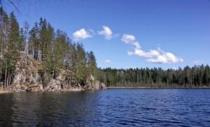
In the water area Indian Ocean, near the South Asian subcontinent, is the island of Sri Lanka. Occupying an area of about 66 thousand square meters. km, it is approximately equal to such large islands as Ireland or Tasmania.
"Lanka" in ancient Indian Sanskrit language means "country, land." The prefix "Sri", widely used in South Asia when addressing highly respected people, reflects the great love that the 15 million Sri Lankan people feel for their homeland. He calls her “blessed, honorable Lanka.”
The nature of Sri Lanka is blessed. But it's not just the lush tropical nature that creates the enchanting experience. Sri Lanka is a country of ancient and distinctive culture, whose history dates back to the first millennium BC. Forest thickets hide the ruins of ancient capitals with the remains of immortal works of human genius.
For four and a half centuries, foreign colonialists ruled the island - Portuguese, Dutch, British. In February 1948, the country achieved independence, turning from a British colony into a dominion. In 1972, a new constitution was adopted and a republic was proclaimed. At the same time, the old name of Ceylon was replaced by a new one - Sri Lanka. Since 1978, the country began to be called the Democratic Socialist Republic of Sri Lanka.
The people of Sri Lanka are on a difficult journey to strengthen and develop their national economy.
Sri Lanka plays a significant role in the non-aligned movement, which covers about a hundred countries around the world and makes an important contribution to the struggle of mankind against the threat of atomic war.
Sri Lanka is part of the British Commonwealth. Area 65.6 thousand square meters. km. Population 13.7 million people (1976). The capital is Colombo. Administratively, Sri Lanka is divided into 9 provinces, governed by provincial councils. The provinces are divided into 22 districts.
PAGES OF HISTORY.
Many scientists believe that the first mention of Sri Lanka is in the ancient Indian epic "Ramayana".
The written history of the country begins in the 6th century. BC e., when immigrants from Northern India, led by Prince Vijaya, landed on the island in 543. The Sinhalese chronicle Mahavamsa tells about this.
Vijaya was expelled from North India. Being the eldest son of one of the rulers, he entered into a struggle for power, but was defeated. With his followers, the prince sailed on a ship from India and, after long wanderings, ended up on the island of Lanka. Prince Vijaya named the island after his family name “Sinhaladvipa”, i.e. “lion island”, and the immigrants from India who settled on it began to be called “Sinhalas” - lion-like. The name of the island of Sinhala English transformed over time into "Silon", which led to the Russian "Ceylon". This is the etymology of the word.
Subsequently, there were several more waves of migration to the island of people from neighboring India. Having pushed the Veddas and other local tribes into the jungle and mountainous part of the country, they settled on a vast, relatively dry plain in the northwestern and eastern parts of the island, and created a large center of irrigated agriculture there.
In the 3rd century. BC e. Sinhalese ruler Devanampiya Tissa united most of the island into a single state. During his reign, the Sinhalese adopted Buddhism. The penetration of Buddhism had a great influence on the development of national culture.
Favorable geographical location islands contributed to the fact that already in the first centuries AD, Sri Lanka became one of major centers international trade. She traded with India, China and other Asian countries. Numerous cities arose on the coast of the island, where foreign merchants conducted brisk trade. This period is considered the "golden age" of Sri Lankan history.
Internecine strife and wars led to the 5th century. n. e. to the collapse of the state, which favored the invasion of Tamils from South India. They seized power on the island into their own hands several times. During this period, the country practically fell into decay.
In the second half of the 11th century. The Sinhalese managed to gather strength and began to fight against the Tamils who came from South India, for the unification of the country. This struggle was crowned with success. A new state was created with Polonnaruwa as its capital.
Irrigation structures necessary for rice cultivation were created. Heavy earthworks to create irrigation structures were carried out by slave prisoners of war captured during continuous wars, as well as communal peasants who were forced to carry out work to maintain irrigation structures. The expansion of artificial irrigation contributed to the further development of agriculture.
At the beginning of the 13th century. The army of the Tamil ruler Magha landed in the north of the island. The invasion of the South Indian conquerors was devastating: cities and irrigation systems were destroyed, cultivated fields were abandoned. As a result of fierce bloody battles, the country was divided between Tamil and Sinhalese rulers.
In the middle of the 13th century. As a result of prolonged wars, the Tamils were pushed back to the northern part of the country - the Jaffna Peninsula and the adjacent areas.
By the beginning of the 16th century. there were about 30 feudal principalities on the island, of which only the Sinhalese kingdoms in Kandy and Kotte were large.
The rich island has always attracted the attention of conquerors - and not only the rulers of South India, but also such a distant country as China.
The first European colonial power to establish control over part of the island country was Portugal. Its ships appeared off the coast of Sri Lanka in 1505. Too late, the king realized that he had become a vassal of Portugal and, as such, was forced to pay an annual tribute of cinnamon, sapphires and elephants. Internal unrest on the island made it easier for the conquerors to seize territory and organize trading posts.
The Portuguese laid the foundation for the future capital of Sri Lanka, the history of which also dates back to 1505.
At the first stage, i.e. Until the middle of the 16th century. The Portuguese fortified themselves on the island. By the end of the 16th century. they no longer needed the services of local rulers.
Beginning of the 17th century in Europe is characterized by a further intensification of the struggle for the acquisition of new colonies, especially among countries such as the Netherlands, England and France. The island of Sri Lanka, with its bases at Colombo and Trincomalee, was valuable as an important strategic hub on ocean routes.
Almost a hundred years after the first appearance of the Portuguese, Dutch ships entered the coastal waters of the island. This was in 1602. They belonged to the Dutch East India Company, which was engaged in trade and colonial conquests in Asia.
Step by step, the Dutch began to oust the Portuguese from the island.
Thus, the history of Sri Lanka is full of dramatic
events. In the 16th century, the island became a colony of Portugal, in the 17th century - of the Netherlands, from the 18th to the mid-20th centuries. - Great Britain. The country gained independence in 1948, and
proclaimed former Ceylon a free and sovereign republic.
Currently, in the context of an aggravated political situation, a rise in the national liberation movement has begun to be observed.
In the 80s and 90s, old contradictions aggravated again in the country. The Tamil Hindus living in the north did not want to submit to the Sinhala Buddhists of the south. The guerrilla war claimed thousands of lives and many Tamils had to flee to India.
Since 1983, the Sinhala-Tamil conflict has entered the stage of open armed confrontation. At the same time, a state of emergency was introduced in the country, which continues (with short interruptions) to this day.
STATE SYSTEM.
Sri Lanka is a republic. The current constitution came into force on May 22, 1972. The head of state is the president, who is also the head of the executive branch and commander-in-chief of the armed forces. The term of office of the president is 6 years. The highest legislative body is the one-party parliament - the National State Assembly, whose deputies are elected for 6 years. The government - the Council of Ministers - is headed by the Prime Minister.
The judicial system includes the Supreme Court. Judges are appointed by the Council of Ministers, members of the Supreme Court by the President.
The official capital is Sri Jayawardenepura Kotte, the actual capital is Colombo (800 thousand, 1991).
ECONOMIC AND GEOGRAPHICAL POSITION.
General characteristics farms.
The main role is played by agriculture, where over 1/3 of the value of the national product is created (in industry - about 1/8). The plantation economy, which developed during the colonial era, forms the basis of the country's modern economy, which continues to be heavily dependent on the external market. Under conditions of independence, a number of state development programs and reforms were implemented aimed at transforming agriculture in order to increase food production, expand energy and industrial construction, and strengthen state control over the activities of foreign capital. State-owned railway transport, port facilities, the largest industrial enterprises, power plants and irrigation facilities; A system of state corporations has been created that manage many industrial enterprises, plantations, and commercial establishments. As a result of the nationalization of plantations owned by foreign and local private capital, more than 400 tea, rubber and coconut plantations came under state control ( total area 160 thousand hectares). All plantations with an area of more than 20 hectares have been nationalized. The activities of foreign banks are limited; All tea trading transactions go through the State Bank of Sri Lanka. Along with the growth of statehood, the positions of the private capitalist sector are preserved and strengthened.
Despite the island position of Sri Lanka, rail and road communications are maintained between it and India. For this purpose, Adam's Bridge is used - a chain of small islands, coral reefs and shoals stretching between Sri Lanka and the mainland. The Indian island of Pamban and some smaller islets are connected to Hindustan by causeways and bridges, and the Sri Lankan island of Manar is similarly connected to Sri Lanka. Ferries carrying trains and cars operate between the terminal stations of Pamban and Manara.
NATURE.
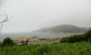
The shores of the island are predominantly low-lying, often lagoonal, fringed by coral reefs, slightly indented, with separate bays. Sri Lanka has preserved its vibrant, rich nature. But it has already been significantly changed by man, many natural landscapes have become anthropogenic, some natural resources suffered exhaustion. To save fertile nature, measures are being taken to protect and rationally use it. Nature reserves and sanctuaries have been created in different parts of the island. national parks.
Relief.
Over 80% of the territory is occupied by low-lying plains, over which individual rocky outcrops rise. In the central and southern parts– stepped highland, with leveled surfaces and steep fault ledges; the upper tier is formed by table surfaces (the tops of most mountains are leveled, which is why they are called table surfaces) and steep peaks - Mount Pidurutalagala (2524 m), Adam's Peak (2243 m), reminiscent of a huge pyramid in shape, etc.
Sri Lanka is one of the largest islands of the globe, but its size is relatively small: the maximum length from north to south is 430 km, from west to east – 225 km. But how diverse, vibrant and uniquely picturesque the nature of this relatively small country is!
Geological structure and minerals.
Sri Lanka occupies part of the Hindu Shield of the Indian Platform, the foundation of which is composed of crystalline schists, quartzites, marbles, etc. Coastal-marine Quaternary deposits (pebbles, gravel, sand, clay) are common along the coast of the Indian Ocean. Main minerals: graphite (with total reserves of 20 million tons), precious and semi-precious minerals (sapphire, ruby, aquamarine, topaz), quartz sand, etc.
Geological history has firmly linked Sri Lanka with the Hindustan Peninsula. From a geological point of view, the island is integral with the Deccan Plateau, which occupies a significant part of India. In the distant past, the titanic internal forces of the Earth separated its southern part from the continent, forming an island.
Oil exploration is underway in the country. According to experts, there are sedimentary structures promising for oil on the Sri Lankan shelf. Since the 80s, exploration work has begun in the shelf zone, for which the state oil corporation of Sri Lanka has entered into long-term contracts with companies in the USA and Canada.
Climate
The climate is monsoonal, subequatorial in the north and east, equatorial in the south and west. The air temperature on the plains is 26 - 300C, in the mountains it drops to 15 - 200C, and changes slightly throughout the year. Sri Lanka is located between 5054' and 9052' north latitude, i.e. close to the equator. Therefore, there is a constant high temperature all year round. In the lowlands, the average annual temperatures are 26 - 280C, the difference between the average temperatures of the hottest and relatively cool months does not exceed 2 - 50C. One of the coldest places on the island - mountain resort Nuwara Eliya, located at an altitude of 2000 m above sea level. This city is called “a piece of the north” on the island. The average annual temperature here is around +150.
The seasons in Sri Lanka are determined not by changes in temperature conditions, but by differences in rainfall patterns. The greatest number of them occurs in the summer - when moisture-rich southwest monsoon winds dominate. The summer monsoon begins in May and subsides in September. At the height of the monsoon period, from June to August, it rains daily, often in torrential downpours.
The greatest amount of precipitation (up to 5000 mm per year) falls on the southwestern slopes of the highlands, at the foot of the mountains - up to 2000 mm per year. The least amount of precipitation (less than 1000 mm per year) is on the northwestern and southeastern coasts. During the spring and fall, many areas experience heavy convective afternoon rainfall.
Inland waters.
The river network is dense. Short, deep rivers (the largest, the Mahaweli Ganga River, “a river with sandy banks,” is 330 km long) begin in the central highlands and spread radially in all directions, forming waterfalls in the mountains. Typically, the length of rivers is 100–150 km.
All rivers are characterized by inconsistency of regime. During the rainy season, they quickly overflow, sometimes causing devastating floods. Lankan rivers are unsuitable for navigation. They are used for irrigation (mainly in the north and east); Numerous reservoirs were built. Small hydroelectric power stations have been built on some rivers.
Soils and vegetation.
The soils are red earth and lateritic, along the river valleys and along the coasts there are strips of alluvial soils. Natural vegetation covers about ¾ of the island's surface. On the southwestern slopes of the mountains and in some places at the foot, moist equatorial forests have been preserved (individual trees reach a height of 80 m) with a huge variety of species. The tree stand consists of palms, dipterocarps, etc.; the forests are distinguished by rich undergrowth and an abundance of mosses. The plains in the north and east of the island and the adjacent slopes of the highlands are covered with secondary deciduous forests (tree height 9-12 m). The plateaus are occupied by savannah-type wastelands (a combination of tall, coarse grasses with isolated trees), above 2000 m there is crooked forest. Along the northwestern and southeastern coasts there are thickets of thorny bushes, and in places near the coasts there are mango forests and coconut palms.
Animal world.
The fauna of Sri Lanka, like the flora, has much in common with South India. Wild elephants remain in the mountain forests of the humid southwest, but as a result of long-term extermination their numbers have decreased. Currently, elephants are protected by the state, hunting them is prohibited, their numbers began to increase and reached two thousand. Richly and brightly decorated, the king of the jungle always participates in solemn religious processions and other festivities.
There are predators in Sri Lanka. The local bear is called a “slobber” - it has long, mobile lips like a small trunk.
There are many monkeys in the forests, and often in the trees surrounding village huts. There are large chiropteran mammals that resemble large bats - flying dogs, squirrels, foxes. Clinging their paws to tree branches, they hang in whole clusters.
In large rivers far from villages there are crocodiles up to 8 m long, so swimming there is prohibited. Lots of poisonous snakes. Of these, cobra and tikpalonga are especially dangerous. The sea and river waters of Sri Lanka are rich in fish, crustaceans, and mollusks.
The fauna is of the Indo-Malayan type, with an admixture of Madagascar species (lemurs). Mammals include the elephant, Ceylon bear, leopard, lynx, 5 species of monkeys, deer, wild boars; an abundance of birds (parrots, peacocks, flamingos, storks), many lizards, snakes, crocodiles. There are a variety of insects (butterflies, ants, termites, malaria mosquitoes, etc.).
HOUSEKEEPING.
Agriculture.
The agrarian reform of 1977, which provided for the limitation of large land ownership, has not yet significantly changed the nature of land ownership and land use. A significant part of the land is still concentrated in the hands of relatively large owners, churches and monasteries. Masses of peasants suffer from landlessness and land scarcity. Slightly shortened rent for the use of land. Two types of farms predominate: capitalist, mainly plantation farms, which widely use hired labor, and small-scale or semi-subsistence peasant farms - tenants or owners. Land leasing is widespread. The process of agricultural cooperation has become an important component of agrarian reforms.
IN agriculture About 37% of the country's territory (2.4 million hectares) is used, mainly in the wet zone, including 895 thousand hectares of arable land, 1084 thousand hectares of perennial plantation crops, 439 thousand hectares of pastures and meadows. 430 thousand hectares are irrigated. Over 40% of the country's territory (2.9 million hectares) is forested. The plantation economy, concentrated mainly in the central and southwestern parts of the island, specializes in the production of export crops - tea, rubber, and coconut palm products. In tea harvesting, Sri Lanka is second only to India and China. Food crops for local needs are grown mainly on peasant farms. The main food crop is rice, which is harvested twice a year. Rice is grown everywhere on the island, but the loose alluvial soils of river valleys and coastal lowlands are most favorable for it. Often, artificial terraces are created on mountain slopes for rice fields. Water flows through a channel diverted from the reservoir from the upper terraces to the lower ones, creating constant moisture in the fields. Rice is usually grown year-round. The winter agricultural season is called maha (large), and the summer season is called yala (small). Since the second half of the 70s, the government of Sri Lanka began to implement a program of modernization and intensification of rice farming. At the same time, the Sri Lankan authorities used useful recommendations UN Food and Agriculture Organization (FAO). As a result of all the measures aimed at increasing the rice harvest, it more than doubled during the years of independence and reached by 1982. 2 million tons. The government sets a goal in the coming years to increase the harvest of rice so much as to be able to abandon its import and even begin exporting in small quantities.
Other food crops include millet, corn, legumes, sweet potatoes, cassava, vegetables, spices (cinnamon, black pepper, cardamom); industrial crops include fibrous and oilseed crops; fruit crops include bananas and pineapples.
Livestock farming is poorly developed; cattle are used more often as draft power. To boost this industry, state livestock farms are being organized and opportunities are being sought to expand the feed supply. There are (1975) 2.5 million heads of cattle (including 0.7 million buffaloes), 0.55 million goats. Elephants are also used as working animals. Sri Lanka is dependent on imports of livestock products and has one of the highest per capita consumption last places in the world. In order to expand the food supply, livestock grazing is being practiced on coconut plantations, and the production of concentrated feed is increasing. Particular attention is paid to the development of dairy farming and poultry farming, but the results achieved so far are small.
The achievements in the development of fisheries are more significant. Since independence, the fish catch in Sri Lanka has increased 6 times. Fishing vessels and equipment are purchased abroad, port facilities and fish processing plants are built. Fish catch 129 thousand tons (1975). Pearl fishing is underway.
Industry.
Sri Lankan industry remains characterized by the predominance of many small, including artisanal enterprises; some large enterprises are created mainly in the public sector.
The island is poor in mineral fuel; fuel is imported. Sri Lanka is a supplier of high-quality graphite to the foreign market; rutile, zircon, salt, and precious stones are mined in small quantities. The main source of expanding the energy base is hydropower. Construction of state hydroelectric power stations is underway.
Traditional manufacturing industries include tea, rubber processing, copra and coconut oil production. Enterprises in these industries are located primarily in areas of large plantations. There are rice cleaning, sugar and other food industry enterprises, as well as textile, footwear and some other light industry enterprises. Heavy industry is in its infancy. Among the mechanical engineering and metalworking enterprises are mainly assembly plants supplying equipment for light industry, transport equipment, agricultural implements, etc. The production of fertilizers, oil refining, and wood processing is expanding. The main industrial center is Colombo and its environs. Ancient traditional crafts (blacksmithing, pottery, weaving) are widespread.
Transport.
Road transport is of primary importance; length highways over 25 thousand km, railways– about 1.8 thousand km – according to data for 1991. (in 1979, the length of railways was 1.5 thousand km, roads - 21.5 thousand km). Most of the foreign sea trade shipping belongs to English companies; its own fleet is also being created. The total cargo turnover of the ports - Colombo (through which up to 90% of imports and over ½ of exports of Sri Lanka is carried out), Galle, Trincomalee - is about 5 million tons. Colombo is of international importance as an air communications hub.
POPULATION
People and culture.
70% of the population are Sinhalese, 20% are Tamils. The Sinhalese (9.8 million people; 1975) inhabit the western, central and southern regions of the country. Official languages– Sinhala, Tamil and English. The Tamils (2.6 million people) constitute 2 separate branches: Sri Lankan (in the northern and eastern regions) and Indian (in the central regions). They speak Tamil. Small peoples of mixed origin include the Ceylon Moors (854 thousand people), the burghers of Ceylon (44 thousand people), and the Malays (42 thousand people). The descendants of the ancient population are the Veddas. By religious affiliation, about 67% of the population (Sinhalese) are Buddhists, over 17.5% (Tamils) are Hindus, 7% (Moors, Malays) are Muslims, 7% (burghers, some Tamils, etc.) are Christians, mostly Catholics . Natural population growth (2.2% per year, 1970-1974) occurs due to high birth rates and a significant decrease in mortality. At the end of the 19th and beginning of the 20th centuries. Immigration from India played a significant role in the increase in population. In 1965 A state policy of birth control was proclaimed. On average, the number of births per 1000 inhabitants was 38 in the mid-40s, and about 27 in the early 80s. The preservation of a fairly high birth rate is associated with the historical, ethnic and religious traditions inherent in the South Asian peoples. They are characterized by early marriage among young people and the custom of having many children. At the same time, as can be seen from these figures, the birth rate in Sri Lanka is declining. In addition to government policies, this is also due to the involvement of more women in social production and the spread of an urban lifestyle. These changes manifest themselves differently among different national groups. The birth rate is declining most among the Sinhalese, some of whose families have begun to deliberately limit the number of children (following the state policy of “family planning”). Higher, unchanged fertility rates persist in families of Tamils and some Muslim groups.
51.3% (1971) of the population are men. In the population of modern Sri Lanka, a large share - over 1/3 - are children. The working population aged 15 to 64 years is about 60%. Older people form a small group - about 5% of the population. In 1971 40.6% of the economically active population was employed in agriculture, mainly peasants and plantation agricultural workers. The average population density is over 200 people per 1 sq. km (on some coastal islands it reaches 400 people). Urban population - 22.4% (1971). The most important cities: Colombo (607 thousand people), Jaffna, Kandy, Galle, Moratuwa.
According to data for 1992 The total population of Sri Lanka is 17.5 million people.
The annual per capita income is $510. The unemployment rate is 11% of the population (mostly young people under 25). The rapid rise in prices remains a negative factor. The measures taken by the government to create new jobs and programs to combat poverty can somewhat reduce the severity of social problems.
In terms of education (literacy level - 95% of the population), Sri Lanka occupies one of the leading places in Asia. Education is free, including university education. More than 30 thousand people study at universities in the country.
Over thirty newspapers and magazines are published in all three Sri Lankan languages. Television is represented by two government programs.
Arts and crafts have long made the island famous. Ancients architectural ensembles, sculpture, painting, wood and metal carving appeared here before our era. Wherever you go, you will definitely come across Sinhala masks in any shop, attracting with their unusual shapes, brightness and rich colors. Handicraft production is still widespread in both cities and villages of the republic. Ancient crafts play a significant role in satisfying the country's internal needs and in the production of some products for export.
National holiday - February 4 - Independence Day. Buddhist or Hindu holidays are widely celebrated in the country. Major Muslim and Christian holidays are also non-working days.
Hospitality has been a long-standing custom of the Sri Lankan people.
FOREIGN ECONOMIC RELATIONS.
Over 90% of export value comes from tea (40-60% of foreign exchange earnings), natural rubber and coconut palm products. The main import items are food; industrial products, raw materials and fuel. The main foreign trade partners are China, Great Britain, Saudi Arabia, Australia, USA, Pakistan, Japan, India.
The monetary unit is the Sri Lanka rupee = 100 cents.
In the international arena, Sri Lanka has taken a pragmatic course. It has been a member of the Commonwealth, led by Great Britain, since 1948, the UN - since 1955, the Non-Aligned Movement - since 1961, the South Asian Association for Regional Cooperation (SAARC) - since 1985. Heads the UN Special Committee on the Indian Ocean. The secretariat of the Indian Ocean Maritime Cooperation Organization (IOMAC) is located in Colombo.
GDP - about 6 billion dollars (annual GDP growth in 1992 - 4.5%). The economic policy pursued by the current government is aimed at liberalizing the economy and creating favorable conditions for the influx of foreign capital. The declaration of the entire territory of the country as a free enterprise zone in 1991 led to a significant increase in foreign investment ($350 million in 1991). Economic assistance from Western donors amounted to more than $1 billion in 1991.
Foreign trade turnover is more than $3.5 billion with a deficit of about $500 million.
In the financial and credit sector, Sri Lanka has achieved some success in recent years. With the growth of external debt ($6.2 billion in 1991), the rate of its servicing decreased in 1991 from 16 to 15%. Foreign exchange reserves – 1.1 billion dollars. The practice of covering budget deficits through foreign aid and domestic loans did not lead to uncontrolled inflation. Over the past three years, the Ceylon rupee exchange rate has been maintained at 40 - 43 Ceylon rupees per dollar.
Geographical location of Sri Lanka.
SRI LANKA, Democratic Socialist Republic Sri Lanka (until 1972 Ceylon), a state in South Asia, on the island. Sri Lanka is in the Indian Ocean, at the southern tip of the Hindustan Peninsula, which is separated by the Gulf of Manara and the Palk Strait, between which there is a chain of Adam's Bridge islands. Area 65.6 thousand km2. Population 20.482 million people (2004).
The actual capital of the country is Colombo. The official capital is Sri Jawayardenapura Kotte, a suburb of Colombo.
The political system of Sri Lanka.
Sri Lanka is a unitary republic. Member of the Commonwealth. The current Constitution was adopted in 1978.
The head of state is the president (elected by universal suffrage for a 6-year term). President of Sri Lanka since 1994 - Chandrika Bandaranaike Kumaratunge (re-elected to a second term in 1999).
The head of government is the prime minister (appointed by the president). Prime Minister since 2004 - Mahinda Rajapakse.
The legislative body is the unicameral parliament (National State Assembly), elected for a period of six years.
Administrative divisions of Sri Lanka.
The territory of Sri Lanka is divided into 8 administrative provinces (Western, Sabaragamuwa, North-East, North-West, Uva, North-Central and South), which consist of 25 districts.
Population of Sri Lanka.
About 74% of the population are Sinhalese (inhabit the western, central and southern regions of the country), 18% are Tamils [two separate branches: Sri Lankan (in the northern and eastern regions) and Indian (in the central)], 8% are the so-called. Sri Lankan Moors (descendants of Arabs); there are also several thousand Veddas (descendants of the ancient population of the island), Sri Lankan burghers (descendants of the Portuguese, Dutch and English), as well as Malays.
The official languages are Sinhala and Tamil, and English is widely spoken.
The national-ethnic composition also largely corresponds to the religious affiliation of the population: Buddhism is professed by about 70% (mainly Sinhalese), Hinduism - by more than 17% (mainly Tamils), Islam and Christianity - by approximately 8% each (Moors, burghers, etc.) .
Largest cities: Colombo, Moratuwa, Galle, Trincomalee, Jaffna, Kandy.
Climate of Sri Lanka.
The climate is monsoonal, subequatorial in the north and east, equatorial in the south and west. The air temperature on the plains is +26-30 °C, in the mountains it drops to +15-20 °C, changing slightly throughout the year. One of the coldest places on the island is the mountain resort of Nuwara Eliya (1881 m above sea level), the average temperature in January is +14 °C, in May +17 °C.
The greatest amount of precipitation (up to 5000 mm per year) falls on the southwestern slopes of the highlands (mainly during the summer southwest monsoon); at the foot of the mountains - up to 2000 mm per year. On the northeastern slopes of the highlands and adjacent plains, most of the precipitation falls during the winter northeast monsoon, and the annual amount decreases to 1000-2000 mm; There is a dry season for 8-9 months. The least amount of precipitation (less than 1000 mm per year) is on the northwestern and southeastern coasts. In spring and autumn, many areas receive heavy convective afternoon (so-called zenithal) rains. Air humidity is about 75%.
Natural resources of Sri Lanka.
The length of the island of Sri Lanka from north to south is 445 km, from west to east - 225 km. The shores of the island are predominantly low-lying, often lagoonal, fringed by coral reefs, slightly indented, with separate ingression bays.
Over 80% of the territory is occupied by low-lying plains (100 m above sea level), above which rise individual rocky outcrops (up to 700 m high), often of bizarre shape (resembling a huge animal, a giant book, or the ruins of an ancient temple). In the central and southern parts of the island there is a stepped highland (average height 1000-2000 m) with leveled surfaces, dissected by faults, and steep fault ledges. The upper tier of the highland is formed by table surfaces and steep peaks - Mt. Pidurutalagala (2524 m), Adam's Peak (2243 m), etc. One of the faults consists of isolated links, generally having a meridional orientation; the other has an arcuate shape and a latitudinal strike; in general they look like an anchor, the rod of which extends from north to south.
Sri Lanka occupies part of the Hindu shield of the Indian platform, the foundation of which is composed of gneisses, granite-gneisses, scoops, amphibolites, crystalline schists, quartzites, marbles with intrusions of Upper Proterozoic granites (about 1 billion years ago), dolerite and pegmatite dikes; carbonatites are known. Basement rocks come to the surface on 9/10 of the territory of Sri Lanka; in the north, the foundation is hidden under a cover of sedimentary rocks (sandstones, siltstones, mudstones, limestones, sands, clays) of Jurassic and Miocene age. Along the coast of the Indian Ocean, coastal-marine Quaternary deposits (pebbles, gravel, sand, clay) are common. Laterites are developed on crystalline rocks.
Main minerals: graphite, precious and semi-precious stones (sapphire, ruby, aquamarine, topaz, moonstone, chrysoberyl, etc.), coastal sea “black” sands with ilmenite and rutile, zircon and monazite; apatite, kaolin and other clays, limestone, feldspars, quartz sand.
Sri Lanka's river network is dense. Short, deep rivers (the largest is the Mahaveli River) begin in the Central Highlands and spread radially in all directions, forming waterfalls in the mountains. Kelani and Mahaoya flow to the western bank, Valava and Nilvala - to the southern, Gal and Yan - to the eastern. Used for irrigation (mainly in the north and east); Numerous reservoirs were built.
The soils are red earth and lateritic, along the river valleys and along the coasts there are strips of alluvial soils.
Natural vegetation covers about 3/4 of the island's surface. On the southwestern slopes of the mountains and in some places at their foot (44% of the entire country), humid equatorial forests have been preserved (individual trees reach a height of 80 m) with a huge variety of species (palm trees, dipterocarps, etc.); the forests are distinguished by a rich undergrowth and an abundance of mosses. The plains in the north and east of the island and the adjacent slopes of the highlands are covered with secondary deciduous forests (9-12 m high). The plateaus are occupied by savannah-type wastelands (a combination of tall, coarse grasses with isolated trees), above 2000 m - crooked forests. Along the northwestern and southeastern coasts there are thickets of thorny bushes, and in places near the coasts there are mangrove forests and coconut palms.
The fauna is of the Indo-Malayan type, with an admixture of Madagascar species (lemurs). Mammals: elephant, sloth bear, leopard, lynx, 5 species of monkeys, deer, wild boars, civets. An abundance of birds (parrots, peacocks, flamingos, storks), many lizards, snakes, crocodiles. There are a variety of insects (butterflies, ants, termites, etc.). The number of large animals is steadily declining due to the expansion of agricultural areas and deforestation.
National parks: Wilpattu, Yala (Rukhunu), Gal-Oya. Reserves: (Ritigala, Wasgomuwa, Khakgala). Near Kandy is the large botanical garden of Peradeniya.
Economy and industry of Sri Lanka.
Sri Lanka is an agricultural country with a developed plantation economy. The share of industry in GDP is about 35%. The economy remains dependent on foreign, mainly English, capital and the foreign market. The role of the public sector is increasing.
St. is involved in agriculture. 70% of the economically active population. Over 1/3 of the territory is cultivated. The basis of the economy is the production for export of tea (one of the first places in the world), rubber and coconut palm products. The main food crop is rice. They also grow millet, corn, legumes, sweet potatoes, cassava, vegetables, spices (cinnamon, black pepper, cardamom), industrial crops - fibrous and oilseeds, fruit crops - bananas, pineapples. Livestock farming is poorly developed; cattle (including buffaloes) are used mainly as draft power. Elephants are also used as working animals. Fishing (including coastal).
Graphite, iron ore, precious stones (ruby, sapphire, aquamarine, etc.), ilmenite, rutile, zircon, salt, mica, limestone, peat, etc. are mined.
Sri Lanka relies heavily on hydropower, so energy production is highly dependent on seasonal fluctuations in rainfall and river flow.
Traditional manufacturing industries include tea, rubber processing, copra and coconut oil production. Light (textile, footwear, paper, etc.) and food (sugar) industries are developed. Mechanical engineering, ferrous and non-ferrous metallurgy, production of building materials, woodworking, and oil refining industries are developing. The main industrial center is Colombo and its environs.
Traditional craft production (blacksmithing, pottery, weaving, weaving of mats, bags, hats, ropes, rugs, artistic carving of wood, horn, ivory, tortoiseshell plate, metal chasing, making gold and silver jewelry with precious stones, etc.) .
Tourism is developing. Coastal (Negombo, Beruwela, Bentona, Trincomalee, etc.) and mountain resorts.
Export: tea, rubber, coconut products, ready-made clothing. Import: textile products, machinery and equipment, oil and petroleum products, wheat, sugar, fertilizers. Main foreign trade partners: Saudi Arabia, USA, UK, India, Germany, Japan.
Near Colombo - international airport in Katunayake.
Main ports: Colombo, Galle, Jaffna, Trincomalee.
The monetary unit is the Sri Lanka rupee. 1 Sri Lankan rupee equals 100 cents.
Capital - Colombo
Geographical location and relief
The state is located on the island of Sri Lanka in the northern Indian Ocean off the coast of India. The terrain is mostly flat, with the exception of a mountain range in the central part closer to the south. The most high point– Pidurutalagala town (2524 m).
Economy
The country is agricultural. About 10% of world tea production is concentrated on the island. The most important industry is textile, which accounts for approximately 60% of exports. Some are also mined natural resources, such as precious stones, graphite, salt. Tourism plays an important role, contributing about 9% of GDP.
Climate
Most of the country is located in the subequatorial climate zone, only on southern shores islands have an equatorial climate (the most rain falls there) large number precipitation in the country – up to 5000 mm). Average temperature air within + 26 °C - + 30 °C.
Population
The population is 21,200 thousand people. It is characterized by multinationality among the inhabitants, the largest ethnic group is the Sinhalese (74%), Tamils (11%), Sri Lankan Moors (9%), descendants of Europeans - burghers (0.3%), Veddas, etc. are also represented.
Sri Lanka is an island with coordinates 7°0" north latitude and 80°0" east longitude. Cartographers and travelers have always compared its shape to a drop of tea or a pearl.
Sri Lanka is separated from India by about 48 km. There is evidence that in ancient times the island was connected to the mainland by a strip of land - “Adam's Bridge”. The area of Sri Lanka is 65,610 km², the size of Holland and Belgium combined. Length coastline 1600 km. The coast is one of the most attractive areas of Sri Lanka. But no less beautiful - and also fertile - are its inland lands, especially the southern ones.
Once upon a time, the entire island was covered with dense jungle, but in the 19th-20th centuries. Most of the forests were cut down, their place was taken by plantations of coffee, tea, palm trees and rubber trees. The main food product of the islanders is rice; coconuts play an equally important role. However, this is not what Sri Lanka is famous for. Her “calling cards” are the most valuable spices, wonderful ceylon tea and of course precious stones, the capital of which is Ratnapura, the “city of jewels”.
In the central part of the island, in the area of the former colonial resort of Nuwara Eliya, is the highest mountain in Sri Lanka - Pidurutalagala (2524 m). But the lower Peak of Adam enjoys much greater fame and universal veneration. Locals They call it Sri Pada, that is, “noble trace.” It is a place of pilgrimage for adherents of all major religions in the country.
Due to seasonal rainfall, Sri Lanka is geographically divided into wet and dry zones, the latter occupying approximately 3/4 of the country's area. The wet zone is located in the southwestern, western, central and southern parts of the island, and the dry zone, respectively, in the southeast, east and north. However, the term “dry” is very relative. During the monsoon season, there are also heavy rains here, but they do not rain continuously, as in the humid zone. There are two monsoon seasons in Sri Lanka. One lasts from May to November and covers mainly the western and southern regions (southwest monsoon), and the other - from November to January, northern and eastern regions countries (northeast monsoon). This means that the most best time for relaxation on the popular southwestern beaches of Sri Lanka - from November to February, that is, when winter dominates in the Northern Hemisphere. But tourists should remember that although they go to the tropics, almost to the equator itself, in the mountainous regions of the center of the country it can be quite cold in the evening and at night, especially on the windswept Horton Plateau. There are several small islands off the northern coast of Sri Lanka, in the Jaffna region. From the south, the endless expanses of the Indian Ocean open up: apart from a few coral islands, there is no other land as far as Antarctica.
The point is that, regardless of the season and location of the resort, there are always many more sunny and hot days on the island, so you can relax there in both summer and winter. It’s not without reason that the state is called paradise on Earth – geography of sri lanka amazes with its diversity and richness: there are also high mountains, and gentle hills and narrow gorges. Geologists explain this phenomenon by the fact that for millions of years the island either sank under the waters of the Indian Ocean or rose out.
The water washed away the rocks of the island, forming its surface. In the middle of the island there is a colorful mountain range, and the rest are quiet lowlands and beautiful coastal areas washed by the sky-blue ocean. This helped develop tourism sri lanka to a high level.
Sri Lanka time
Sri Lanka is located at 800 km. from the equator and 180 degrees from the Prime Meridian. Therefore – UTC +6. By time Sri Lanka ahead of Moscow by two hours, and Kyiv by three. When calculating time, transition to other time modes should be taken into account.

Climate of Sri Lanka
Proximity to the equator and unusual geography greatly influenced . The center and north of Sri Lanka is located in the subequatorial zone, and the eastern and western part in the equatorial. The island is protected from temperature changes by a mountain range that stops gusts of wind, so it is warm here all year round. This idyll is overshadowed only by the summer rainy season, which lasts from June to August. The rest of the time the weather is hot, dry and calm.

Sri Lanka weather
Throughout the year, the temperature ranges from +27 to + 30. Temperature fluctuations in the hottest and coldest months do not exceed 5 degrees. Sri Lanka weather in cities it is characterized by high humidity, while the coast is more comfortable for relaxation due to the influence of the ocean.

Nature of Sri Lanka
The climatic zones and geography of the island determine its lush flora and fauna. In the green jungle, entwined with vines and orchids, you can meet exotic animals with incredibly bright colors. There you can meet monkeys, lemurs, huge insects and birds. As soon as the sun sets, predators enter the arena of the animal world - tigers, lions and leopards. Nature of Sri Lanka preserved thanks to careful Buddhist traditions, which helped protect such rare species like wild elephants.