What a lake in Altai. Altai lakes: where is the best place to go on vacation? The largest lake
Altai is famous not only for its mountains - there are also a lot of lakes here, and all of them add special picturesqueness to the already beautiful landscape of this region.
Lake Teletskoye is one of the most popular natural attractions of the Altai Mountains. In terms of maximum depth, it ranks fourth in Russia. In addition, Lake Teletskoye is an object World Heritage UNESCO.
The lake received its modern name four hundred years ago - it was given to it by Russian pioneers, calling the lake Telessky, since the Teles tribes lived here. And the Teles themselves called it Altyn-Kul, or Golden Lake.
The length of the lake is 77 kilometers 700 meters, the average width is about three kilometers. The average depth of the lake is 175 meters, and the maximum is 325 meters, so you can safely sail here on boats and ships. True, swimming here is not very comfortable - only at the end of July in the southern part the water warms up to 22 degrees. In total, 70 rivers flow into the lake, but most of the water comes from the Chulyshman River.
The right bank of Lake Teletskoye belongs to the Altai State Nature Reserve, and getting there is very difficult, and in some places it is impossible, so some attractions are only accessible from the water.
Getting to Lake Teletskoye by car is not so easy - there are only three places accessible by car:
- Yailyu village;
- South shore of the lake;
- Artybash, Northern shore of the lake.
Locals like to say that if you haven’t been to Lake Teletskoye, you haven’t been to Altai. In general, they say this about many places, but specifically about the lake these are not empty words, but the real truth.
On Lake Teletskoye you can see all the most remarkable things in a couple of days, but there will be plenty to do there for a whole week. True, excursions here are not cheap, but on your own, up to many interesting places simply can't get there. Accommodation on the lake is not that expensive, but without tourist trips there is, in general, not much to do here. It is better to book accommodation in advance, especially in July-August.
The lake is famous for its picturesque views, as well as attractions: waterfalls such as Kishte, Korbu, Ayu-Kechpes, etc., Stone Bay and numerous beautiful islands. By the way, there are about 70 waterfalls on the lake, but not all of them can be approached.
Lake Aya is a very significant natural site in Altai, and there are many legends about it. “Aya” is translated into Russian as Moon, and tourists are usually told a legend associated with the Moon. It says that once in these lands there lived the cannibal Delbegen, who killed a lot good people. One day the Moon got tired of watching these outrages, she descended to the ground and threw the cannibal into the Katun. At the same time, high waves and a trace left by the descending moon rose. This is how Lake Aya was formed.
The age of the lake is approximately 25 thousand years. It is located at an altitude of 280 meters above sea level. The length of the lake is about 400 meters, the width is about 380. The maximum depth is 21.7 meters, although there is data about 25 meters. The total area of the lake is 93 hectares. From November to April the lake is covered with ice, but in July the water in it warms up to 22-26 degrees, which allows you to safely swim in it - and not everyone can boast of this Altai Lake.
A special feature of the lake is a small granite island near the eastern shore, on which there are several trees and an old gazebo. And in 2003, Aya and its surroundings were given the status of a natural park.
On the shore of the tourist center there are many hotels, campsites and recreation centers. Accommodation can be found from almost 100 rubles per day at a campsite for a tent space and from only 500 rubles for an economy class room. In general, the prices are quite reasonable.
Tourist bases near the very shore of the lake have access to own beaches. Considering that there are not many places for swimming in Altai, Lake Aya is very attractive in this regard - you can safely swim and sunbathe here. If you are not relaxing at a base near the shore, then you will have to pay for access to the lake.
The beaches of Aya are well-maintained - here you can rent umbrellas and sun loungers. There are boats and catamarans on the lake, but their rental is not cheap - about 400 rubles per hour.
In general, there are many interesting sights around Aya that are easy to visit on your own by car or as part of excursions.

The Karakol Lakes are a chain of lakes in the upper reaches of the Karakol River. There are seven lakes in the chain, and they are located at an altitude of 1820-2100 meters, connected by streams and channels.
Although the lakes are connected, the water in all of them is of a different color, but everywhere it is very cold - no higher than seven degrees.
The strong difference in elevation between the lakes provides an interesting variety of landscapes. The cedar taiga stretches around the lower lakes, a little higher the taiga is replaced by alpine meadows with amazing flowers, and the small upper lakes are surrounded by alpine tundra. All this makes the lakes very picturesque.
The Karakol lakes are a natural monument, and tourists regularly visit them.

Behind the Red Gate, on the road to Katu-Yaryk, there is a chain of Ulagan lakes. It starts from the lake Cheybekkel, or Dead Lake, which stretches along the road for several kilometers.
The lake began to be called that because there was no fish there for a very long time. This was explained in different ways, from the high content of mercury in the water to the activity of evil spirits. The first, by the way, was not confirmed, but the second cannot be reliably verified.
In the end, everything turned out to be simpler. To get into the lake, the fish had to be raised upstream of the Chibitki River. And Cheybekkel, located at an altitude of 1949 meters, was simply inaccessible for fish. A few years ago, a private entrepreneur rented the lake and put fish there by hand. After that, the lake ceased to be Dead - the fish took root there remarkably well, and now fishing here, according to local residents, is quite good.
But its native name, Cheybekkel, that is, Elongated Lake, is more consistent with reality. The length of the lake is 3 kilometers and the width is only 400 meters. The depth of Cheybekkel is 33 meters. By the way, the ice lasts here for quite a long time - you can see it even in June.
Further along the road to the pass there are many more lakes, some of which are difficult to identify. There are camp sites near the shores, and the view of the lakes is excellent. Just before the Ulagan pass is located Lake Uzunkel. Its height is 2 thousand meters above sea level, that is, it is one of the highest mountain lakes in the Altai Mountains. And Uzunkel is the most big lake in the Chibitki basin. Its width is 600 meters, length is 2.5 kilometers, and depth is up to 28 meters. Some time ago, fish were also released into the lake, so you can go fishing here.
Very beautiful lake Uch-Kel can be seen along the same road near the Katu-Yaryk pass.

This is the second largest lake in the Altai Mountains (after Teletskoye), located at an altitude of more than two kilometers above sea level, on the Chulyshman plateau. Its length is 10 kilometers and width is 3 kilometers.
The lake is interesting for two things. Firstly, numerous islands, on two of which there is a colony of the great cormorant, the only one in Russia. Secondly, the unique landscape around the lake, the tundra-steppe, which mixes the flora and fauna of the north and south of Siberia.
There are also more than two hundred small lakes around Julukul, so the area here is quite picturesque.

These high-mountain lakes are located in the upper reaches of the Shava River, at an altitude of up to two thousand meters, on the southwestern slope of the North Chuysky ridge. They are considered to be almost the most picturesque lakes in the Altai Mountains, since the local landscapes combine alpine meadows and coniferous forests, and the mountain peaks surrounding the shores of the lakes make this place even more beautiful.

This alpine lake is located on the Akkem River, at an altitude of more than two thousand meters above sea level. It is located at northern slope popular Belukha Mountain. The width of the lake is 610 meters, the length is 1350 meters, and the depth reaches only 15 meters. The water in the lake is extremely cold, and even in summer it does not warm up above five degrees Celsius.
The shores of the lake are low, covered with cedar and deciduous forest. The lake itself is not that remarkable, but it is very easy to access other mountain lakes, waterfalls and Belukha glaciers, so many tourists stop here.

This group consists of three lakes: Verkhnee and Nizhneye Kucherlinskoye and Bolshoye Kucherlinskoye. All of them are located next to each other on the right tributary of the Katun, the Kucherla River, right at the base of the northern slope of the Katunsky ridge. The lakes are quite alpine - they are located at an altitude of about 1790 meters above sea level.
Tourists love these lakes for the unique flora and fauna and picturesque landscapes in their surroundings. Not only tourists and travelers, but also hunters often stop here. True, even in the summer it is cool here, although this only benefits those who want to take a break from the scorching heat. You won't be able to swim in the lakes either.

Kolyvan Lake is one of the most large lakes Altai region. Tourists love it for the bizarrely shaped rocks located around the lake, as well as for the crystal clear water. Thanks to this water, the water chestnut chilim, a relict plant listed in the Red Book, still grows here.

Kulundinskoye Lake is the largest lake in the Altai Territory. Its length is 35 kilometers, width - 25 kilometers, and its area exceeds 600 kilometers. With all this, the lake is very shallow - the most deep place here it is only 4 meters. Kulunda Lake is the remnant ancient sea, which was on the territory of the Altai region millions of years ago.
The lake is famous for its healing clays and healing mineral waters, so on its shore there is a healing and health complex that attracts many tourists.

White Lake can be seen in the Kuryinsky district of the Altai Territory, where it is located in the basin of the Kolyvan ridge at an altitude of about 530 meters above sea level. The maximum depth of the lake is about 8 meters. The lake is part of the Loktevka River basin, which is one of the tributaries of the Charysh River. Not far from the lake is Mount Sinyukha, which is the highest point of the Kolyvan ridge. Also close to the lake is the village of 8 March.
The lake is home to a variety of fish, making it a desirable destination for fishermen. Mostly ruffs, perches, and minnows live here; there are roaches, pikes, tenches, and crayfish. The shores of the lake are covered with various shrubs: willow grass, honeysuckle, viburnum, and rose hips. In the center of the lake there is an island made of granite cliffs. According to legend, on this island in the 18th century there were secret workshops of the famous entrepreneur Akinfiy Demidov, who minted coins from gold and silver.
The lake with a rocky bottom and warm, clear water is suitable for swimming. Relax in these picturesque places Tourists from all over Russia flock to the mild climate. For the convenience of vacationers, the Skala base is located on the shore of the lake, open all year round. Lake Beloe is recognized natural monument of national importance.
Coordinates: 51.81477000,80.35831900
Lake Uzunkel
Lake Uzunkel is the largest body of water in the basin of this river. The deepest point of the lake is 28 meters. On the shore of the lake, on the north-eastern side, there is a tourist center called Uzunkel. The stream that comes out of the river first passes through small lakes, and then follows to the right, into the Chibitka River.
The shore on the western side of the lake is very swampy, the coastal slopes are quite steep, they are covered with a large amount of vegetation - moss and dwarf birches, cedars and larches go up to the mountains. Lake Uzunkel is fed by small flowing streams, as well as melt, groundwater, and rainwater.
Coordinates: 50.48787600,87.62652400
Lake Avras
Avras is a low-mineralized lake located in Russia, in the Chulym-Yenisei basin, two kilometers east of the Maly Kobezhikov aal, in the Shirinsky district of the Republic of Khakassia, on the right bank floodplain of the Kolekdzhul River.
To the south of Avras is the village of Fyrkal, and to the north is the village of Maly Kobezhikov.
Lake Avras belongs to the group of Shirinsky lakes. Its area water mirror is 43.5 hectares, length coastline– 3.4 kilometers, and the absolute water line here is 513.4 meters. The lake is used for recreational and household purposes. It is home to many species of fish.
Coordinates: 54.54238900,89.76516700
Khomutinoye Lake
Lake Khomutinoye is located in the Burlinsky district of the Altai Territory. It is located in a basin in the river valley. The Burla River flows through the lake. The length of the lake is approximately 8 kilometers, width - about 3 kilometers. It has a maximum depth of 3.6 meters, an average depth of 2.2 meters.
The shores of the lake are swampy, southern shores steep, the height of the banks is approximately 4-6 meters. The lake is home to fish and is an excellent place for fishing. Suitable for winter fishing. Khomutino Lake is home to crucian carp, pike, perch, roach, sorog, roach, and pike perch.
Coordinates: 53.43776100,78.69367900
Lower Shavlinskoye Lake
The deepest point of Nizhny Shavlinskoye Lake is 40 meters. This lake is increasingly covered with silt. In the middle of the lake you can see quite large shallows, which in some places are overgrown with sedge. Large expanses of water are noticed solely by the area of the banks, especially on the right side. The shores of the lake are quite low, swamps are noted in places, and sparse forest is observed along the banks.
On the eastern side of the shore there is a tourist parking lot for rest before going to the middle lake.
Coordinates: 50.61810300,86.23168900
Lake Maloye Yarovoye
Small Yarovoye Lake is one of the scattering of salt lakes in the Altai Territory. It is small in size and has an almost regular geometric shape.
The lake lies in the steppe and seems to cut through a flat empty space furrowed with ravines with a deep basin. The shores of the lake are mostly steep.
Based on the composition of salts, the lake is considered bitterly salty. The salt concentration is such that it is impossible to swim in the lake water. But here the processes of mud formation are actively underway. Small Yarovoye Lake is valued as balneological resort. True, there is no special tourist infrastructure on these shores. But every year in the summer a tent camp is organized here and “savages” come for medical treatment.
Coordinates: 53.03625900,79.13377800
Strong Lake
Lake Krepkoe is located 1 kilometer 933 meters above sea level. It is located in the tributary of Proezdnaya Multa on the right side, in the upper reaches of the river called Krepkaya.
The shore part of Lake Krepkoye is covered with birch thickets and sparse forest. There are steep cliffs on three sides of the lake shore. A waterfall flows from the southern part of the lake, which then goes into the valley.
There are 4 more lakes nearby. Their name, collectively, is “Strong Lakes.” They are located on the territory of the pass circus. All of them have turquoise water color.
Coordinates: 49.95133000,85.78305200
Lake Krasnoe
Red Lake is located in the Beysky district of the Republic of Khakassia in the Koibal steppe. This is an artificially created lake that appeared during the construction of the Koibal irrigation system. It was created on the basis of the large brackish lake of Estonia.
It is located 4 kilometers from the village of Novonikolaevka and 75 kilometers from Abakan.
The lake serves as a water intake from the Uysk irrigation system. In the irrigation system, the lake plays the role of an emergency water intake from the main canal of the Koibal irrigation system. An irrigation function has also been added to the lake.
The area of the water surface is 0.77 square kilometers, the volume of water is 1.3 square kilometers, the length of the coastline is approximately 4 kilometers, and the maximum depth is up to 10 meters.
There are several livestock buildings on the banks. The lake is used to irrigate pastures and is stocked with whitefish.
Coordinates: 53.20694400,91.23555600
Bolshoye Yarovoye – a healing lake in the Altai Territory
Far beyond the borders of the Altai Territory, the healing properties of the mud of Lake Yarovoe are known. In many physical and chemical indicators and potential, Bolshoye Yarovoye is an analogue of the Dead Lake in Israel.
Lake Sredneye
Lake Sredneye is located in the Aleisky district of the Altai Territory, in a ribbon forest, in the Barnaulka river system. The length of the lake is 6 kilometers, width - 1.5 kilometers, water surface area - 7.07 square kilometers. The lake has an average depth of 1.5 meters, a maximum depth of 1.7 meters.
The lake is shallow and warms up well to the very bottom in the summer months. The water temperature in the lake in summer reaches 20-26 degrees. The bottom of the lake is covered with silt. Coastal aquatic vegetation is mainly represented by reeds and reeds; there are also cattails, comb pondweed, and rhizomes.
Coordinates: 52.61670600,82.16666700
Kulunda Lake
Kulunda Lake is located on the Kulunda Plain, in the Altai Territory, at an altitude of 98 meters above sea level. It is considered the largest lake in the Altai Territory, its diameter is about 35 meters. The average depth of this slightly salted lake is 2.5 - 3 meters, the maximum is about 5 meters. The rivers Suetka and Kulunda flow into the lake.
In summer, in shallow waters, the lake warms up to 26 degrees Celsius. The lake water is rich in various salts that are beneficial for health. The bottom of the lake is sandy, but there are areas with healing silt mud formed by crustaceans of the species Artemia salina.
The lake is included in two reserves: Suetsky and Blagoveshchensky. On the lake itself and in its surroundings there are various animals and birds, including rare, endangered species listed in the Red Book of the Altai Territory and the Red Book of Russia: great jerboa, steppe kestrel, saker falcon, and so on. During seasonal migrations, many waterfowl rest and nest on the lake.
Lake Kulundinskoye is a good place to relax. Here you can admire the steppe landscapes, sandy beaches, shallow waters and warm water with healing properties create all the conditions for a pleasant and healthy bathing. The lake will also please fishermen; it is home to pike and perch. In the vicinity of the lake there is the village of Znamenka, as well as sanatoriums and hotels.
Coordinates: 52.96966200,79.49874600
Kuchuk Lake
Lake Kuchukskoye is located in the Blagoveshchensky district of the Altai Territory, on the Kulundinskaya Plain. The width of this rather large reservoir is 12 kilometers, length - 19 kilometers. The water of this unique lake contains large number various salts, due to which it has medicinal properties. The black mud lying at the bottom of the lake is also healing. The waters of the lake, which have a pinkish tint, are inhabited by the crustacean Artemia salina, which contributes to the creation of therapeutic mud.
Due to its shallow depth of about 3 meters, the lake warms up well in summer, making it convenient for swimming. After swimming in the lake, the salt must be washed off the skin, so you should stock up on fresh water in advance. There are no recreation centers on the shore of the lake, so tourists visiting the lake camp on the shore in tents. You can admire the beauty of the lake in winter, as it does not freeze due to the high concentration of salts in the water.
Raw materials from Lake Kuchuk are supplied for processing to the Kuchuk sulphate plant. Lake water and healing mud are used in the sanatorium in the village of Stepnoe Lake.
Coordinates: 52.71478100,79.80324100
Blue Lake
The unusually picturesque Blue Lake is located in the Altai Republic. Blue Lake is located on the slope of another natural reservoir - Lake Kucherlinskoye. The lakes are connected by a stream. Lake Goluboye is relatively small, its length is slightly more than a kilometer, and the width is only 270 meters. The origin of the lake is related to the melting of the glacier many centuries ago. The beautiful clear blue surface of the lake, in which the sky is reflected, apparently played a role in the name of the reservoir. The lake is located at an altitude of 2300 meters above sea level.
There are gorgeous landscapes around the lake, you can just walk and admire this beauty. Everywhere there are alpine meadows with herbs and fragrant flowers. Beautiful snow leopards are coming up to the lake, perhaps to drink. And Siberian mountain goats may also drop by.
Coordinates: 49.85798800,86.45408000
Lake Balankul
Balankul is a lake in a natural depression, located in the Republic of Khakassia in the subtaiga zone of the Askiz region, in the spurs of the Kuznetsk Highlands.
This is an oval lake, the length of which is a little more than a kilometer. It has sandy and sand-gravel shores, and in south bay In some places there are wetlands. The greatest depth is 6 meters, the bottom is flat. From the western and eastern shores the forest comes close to the water. On the eastern shore there is an equipped beach for vacationers.
The height of the water mirror is 836 meters, the area is 0.4 square kilometers. In the northern part of the lake, the shores are composed of sedimentary rocks, with powerful springs emerging from them. Significant fluctuations are observed in the area, volumes and depths of Balankul. Every 12 years, significant tides return, and the size of the lake increases. The volume of water is from 120 million cubic meters, the maximum depth is 1.5-6 meters.
Fresh water has high quality and mineralization level up to 0.4 grams per liter.
The lake is home to perch, pike, carp and tench. In places where springs emerge there are natural wintering pits.
Lake Balankul is mainly intended for the health of children.
Coordinates: 53.46111100,90.41222200
Akkem Lake
The basin of Lake Akkem resembles a mountain valley created by the melting of a glacier. The entire coastal zone around the lake consists of loose glacier deposits, covered in places with moss.
The length of the lake is 1 kilometer 350 meters, which is directed from south to north. The width of the lake is about six hundred meters. The maximum depth in the lake is 15 meters, the shore slope goes down very sharply. The average depth of the lake is almost 8 meters.
Due to the accumulation of sand, pebbles and gravel, which were brought into the lake by the Yarlu River, from the north of Lake Akkem, there is a narrowing.
The water in Lake Akkem is very muddy, closer to light gray in color. Visibility on the lake is no more than one meter deep.
Coordinates: 49.90790300,86.54617300
Sadrinskoye Lake
The lake got its name from the Sadra River, which flows from it. Since 1978, it has been recognized as a natural monument of the Gorno-Altai Autonomous Okrug.
Lake Sadrinskoye is covered by black taiga; the lake is located in the lowlands. The area of the water surface is 530 thousand square meters. It is located 770 meters above sea level. The lake is irregularly rectangular in shape, slightly elongated in length from the northwestern part to the southeastern part. The area of the lake in hectares is 51, the width is 450 meters, and the length is 1 kilometer 300 meters.
Coordinates: 52.00258500,87.99083200
Sandy Lake
Lake Peschanoe is located in the Altai Territory, in the Burlinsky district. It is located at an altitude of 114 meters above sea level. The length of the lake is approximately 8 kilometers, the width of the lake is about 4 kilometers, and the area of the lake is 26 square kilometers. The maximum depth of the lake is about 4 meters, the minimum depth near the shores is about half a meter. In some places the banks are steep, their height reaches 4 meters. This fresh lake with a sandy bottom is a great place to relax.
The lake is surrounded by a centuries-old pine forest, which makes it possible to breathe the cleanest air. In the vicinity of the lake there are many sanatoriums, recreation centers, and cottage villages. Additional amenities are provided by bars and cafes located on the shores of the lake. Sanatoriums and recreation centers, in addition to accommodation, provide a lot of opportunities for active recreation: games of badminton, football, volleyball, table tennis, paragliding, walking and horseback riding and much more. The recreation center "By the Lake" rents boats and jet skis to its guests for riding on the lake; in winter it provides skis, snowmobiles and skates.
The lake is a real paradise for fishermen. In summer you can fish here from the shore and from a boat, there are also opportunities for winter fishing. The lake is home to fish such as bream, roach, pike, perch, burbot, pike perch, ide, and crayfish.
Coordinates: 53.40864100,78.57951000
Cheybekkol lake
Lake Cheybekkol is considered a unique natural phenomenon of its kind. It was formed as a result of the filling of the river with a relief, slightly convex semi-cone, which was pushed into the valley from the slope on the eastern side. Lake Cheybekkol is of the dammed type.
Previously, the lake was called Dead, due to the fact that there were no fish in it. Due to the fact that, according to the assumption, the water contained a large amount of mercury, which made the water unviable. But after recent research, it became clear that the mercury in the water was within acceptable limits, but there were no fish in the lake, because they simply could not easily overcome the steep Chibitka River. IN at the moment Since then, the lake has been leased, and fish are safely bred in it.
Coordinates: 50.39659100,87.60721200
Transverse Lake
The transverse lake is located 1885 meters above sea level, and its deepest point is almost 23 meters. It is included in the territory of the Katunsky Nature Reserve. The Poperechnaya River flows out of the lake into the right tributary of the Multa River. The lake is fed by karst-valley glaciers.
From a distance, the lake looks very contrasting due to the fact that the shores of the lake are practically devoid of forest vegetation and are illuminated by the whitest glaciers and snowfields. It is the most beautiful of all the Multinsky lakes.
Above the Transverse Lake there is Verkhnee Poperechnoe, at an altitude of 2000 meters, and then there are small karst lakes.
Coordinates: 49.92790900,85.88922500
Lake Kaldzhin-Kol
A dirt road has been laid to the shores of Lake Kaldzhin-Kol on the southern side. The height of the line of intersection of the land surface and the water surface is 2 kilometers 401 meters.
A river flows from Lake Kaldzhin-Kol-Bas into Kaldzhin-Kol Lake, a tributary on the left side of the Ak-Alakha River. On the southern side of the lake there is a small island measuring 100 by 50 meters.
On the eastern, northern and western sides there is a limitation caused by the mountain slopes.
The lake has a very beautiful and picturesque view. And it is a favorite place for tourists to visit.
Coordinates: 49.32338800,87.45795200
Big Poplar Lake
Big Poplar Lake is located in the Burlinsky district of the Altai Territory, at an altitude of 99 meters above sea level. The Burla River flows into the lake. Its area is 76.6 square kilometers, the length of the lake is 13.4 kilometers, the width is 8.2 kilometers. The lake has a maximum depth of 2.5 meters, an average depth of 2 meters. The bottom of the lake is sandy.
This lake is home to rudd, bream, whitefish, pike, perch, dace, sterlet, bleak, roach and other fish. Fishing flourishes on the lake; you can fish both from the shore and from boats. The water level in the lake is mainly replenished by melting snow. Sometimes the lake dries out completely, and then a wet meadow forms in its place.
Coordinates: 53.32609600,77.98136400
Burlin Lake
Burlinskoye Lake is located in the Slavgorod region of the Altai Territory. The maximum depth of the lake is 2.5 meters, the average depth is less than 1 meter. The lake has an area of 31.3 square kilometers. At the bottom of the lake, under silt deposits, there are deposits of Glauber's salt. This salt water lake is the largest deposit of table salt in Western Siberia. On its shore is the village of Bursol.
The main enterprise of the village of Bursol is the Burlinsky salt mine. Table salt has been extracted from the lake since 1768.
In winter, the lake level rises, which is due to the lack of evaporation of water and the influx groundwater. The lake does not freeze because the salt it contains turns solid precipitation into water. The color of lake water changes depending on the ambient temperature: the lake can be pink, steel or blue. The pink color of the water is given by the special species of crustaceans that live in it. Halophytes grow on the shores of the lake - plants that love saline soils.
The amazingly beautiful lake with healing silt and healing water, saturated with many healthy substances, attracts residents of surrounding settlements and numerous tourists. There is a sandbank on the shore of the lake, which is a nice beach.
Coordinates: 53.14023400,78.41649600
Lake Firkal
Lake Firkal is located in the Shirinsky district of the Republic of Khakassia, in the Chulym-Yenisei basin, 24 kilometers northwest of the Lake Shira resort.
This is a flowing fresh lake, the area of which is 8.7 square kilometers, the absolute height of the water’s edge is 411.3 meters, and the length of the coastline is 17.5 kilometers.
The Kolekdzhul River flows into the lake, and the Abdinka River flows out - the right tributary of the White Iyus River. Southern and western shores swampy, with thickets of reeds growing on them. In the northern part of the coast there is aal Firkal. The chemical composition of slightly alkaline water includes bicarbonate, calcium and magnesium.
The sloping bottom is covered with a layer of dark gray silt. There is data that confirms that these silts belong to the medicinal muds of the transitional type; their properties can be equated to sapropels. The lake has no depth; there is a very small amount of fish in it.
The snort is used for recreational purposes.
Coordinates: 54.62099000,89.80625200
Great Island Lake
The large island lake is located in the Mamontovsky district of the Altai Territory at an altitude of 205.5 meters above sea level. The basin of the lake is located in the valley of the Kasmala River. The water surface area is 28.6 square kilometers, the average depth of the lake is 1.8 meters, the maximum is 5.6 meters. The Kasmalinsky ribbon forest extends along the eastern shore of the lake. On the shore of the Big Island Lake is the village of Mamontovo.
The Big Island Lake is connected by an isthmus to the Small Island Lake. The bottom of the lake is muddy, its shores are very swampy, covered with thickets of reeds, reeds and cattails. The surface of the lake is covered with a large amount of floating vegetation: polyroot and duckweed. The lake is home to crucian carp, pike, and roach. Cleanup of Great Island Lake began in 2012 to remove excess silt deposits and improve water exchange in the lake.
Coordinates: 52.73975100,81.70335300
Small Yarovoye Lake
Small Yarovoye Lake is located in the Slavgorod region of the Altai Territory. The lake is small in size. The water of the lake is clean and bitterly salty; its composition is chloride-sulfate-sodium. Lake brine, which is a highly mineralized solution, creates excellent conditions for the formation of mud, which has many healing properties. The creation of healing mud is also facilitated by a special crustacean that lives in the lake.
Since 1985, the healing mud of the lake has been delivered to the mud baths in the city of Yarovoye, located 50 kilometers from the lake. Scientists believe that in terms of its high healing qualities, the mud of Maly Yarovoye Lake is no worse than the mud of Odessa resorts and the resort of the city of Saki in Crimea.
The unique properties of Maly Yarovoye Lake attract numerous tourists who come here to relax and improve their health. In July, a tent camp is located on the shore of the lake.
Coordinates: 53.03386400,79.12844300
Upper Tuyuk Lake
Its length is almost 250 meters and its width is 265 meters. The total distance of the coastline is 1 kilometer 50 meters.
The lake has the shape of a circle, slightly elongated from the south to the north. In the western part of the lake, the shores are bordered by very steep walls of the kar, on the other sides they are surrounded by stone relief. Flowing waters pass through the lake. It is connected to the Lower Lake by a small stream. The lake is fed mainly by groundwater and sediments. On the southern side of the lake is the deepest point, which is almost seven meters. The water in this lake is clear and fresh. Its surface temperature in June is 15-16 degrees.
Coordinates: 50.63204200,86.22070300
Lake Kaldzhin-Kol-Bas
It is located on the western part of the plateau. Lake Kaldzhin-Kol-Bas is located at an altitude of 2 kilometers 405 meters above sea level. On the western side of the lake, a small river flows into it. Only one river flows out of Kaldzhin-Kol-Bas on the eastern side and is the drainage of Lake Kaldzhin-Kol. And the Kaldzhinkol River emerges from Kaldzhin-Kol, which is a tributary on the left side of the Ak-Alakha River. There is a small island near the mouth of the river that flows into it. On the western and northern sides of the lake there are mountains; they reach a height of two kilometers and 967 meters.
Coordinates: 49.31533100,87.40834200
Lake Darashkol
The name Darashkol translated from Altai means “Beautiful Lake”. You can’t call it more precisely, because the lake literally amazes with its beauty, leaving strange and mesmerizing pictures in the memory for a long time.
This miracle of Altai nature is located in the upper reaches of the Ioldo-Ayra valley, the left tributary of the Kucherla River at an altitude of 2140 m above sea level. The lake stretches from east to west for approximately 1 km and is comfortably located among a basin surrounded by pointed rocks. On the southern side, a cape juts out into the lake, its outline very reminiscent of the famous “Italian boot” - a granite massif covered with moss and bergenia. Thickets of lingonberries and blueberries, low cedars that twist whimsically under the pressure of all the elements, heavy mossy stones - everything here is strict and harsh, but this is the inexplicable charm of these places.
To the east from the “boot-peninsula” there is a view of the peaks of the Katunsky Range - the Crown of Altai, and behind it the famous Belukha, the highest point in Siberia. In clear weather and setting sun, the panorama is especially amazing. At this hour, the color of the water suddenly changes from turquoise to emerald, the glaciers sparkling in the distance blind the eye, the eternal greenery of cedars spreads all around, and at the same time, the lighting changes every minute. All this creates the special attractiveness of the lake as an amazing and fantastic place.
Coordinates: 49.82616200,86.35120900
Chernokurynskoye Lake
Chernokurynskoye Lake is located in the Mamontovsky district of the Altai Territory, in the southeast of the Kulunda steppe. It is also called the Great Bitter Lake or Bitter Lake. It is located in the basin of the Kasmala River. It extends 50 kilometers from southwest to northeast.
The area of the lake is 140 square kilometers. Its width is approximately 6 kilometers. The maximum depth of the lake is 7.2 meters. The lake has flat shores, the water of the lake is bitterly salty.
Coordinates: 52.47485000,81.32512300
Raspberry Lake village
The village of Raspberry Lake is located on the shore of the lake of the same name, in the Kulundinskaya steppe, in the Mikhailovsky district of the Altai Territory. Raspberry Lake, on the shores of which the village is located, is famous for its healing salt water and healing mud. The village is small, with about 3.6 thousand inhabitants. The main enterprise of the village is the Mikhailovsky Chemical Reagents Plant, which operates on raw materials from the Mikhailovsky Lakes group.
The village has a developed infrastructure: there are shops, a recreation park, a clinic, schools, and a House of Culture. The village is well landscaped and pleasant to walk around. The residents of the village are distinguished by their hospitality and cordiality.
The healing Raspberry Lake, clean air, saturated with the aroma of pine trees, attract many tourists to these places. A recreation center has been built on the shore of the lake with many houses for vacationers; those who wish can stay in tents. In the village of Raspberry Lake there is an opportunity to purchase natural, environmentally friendly products.
Coordinates: 51.67662400,79.78615300
Big Spring Lake
Big Yarovoye Lake is located in the Slavgorod region of the Altai Territory, in the west of the Kulunda Plain. The length of the lake is 11.5 kilometers, width - 8 kilometers. The greatest depth of the lake is about 7-8 meters, the area is 54 square kilometers. Considered the most deep lake Kulundinskaya plain. The lake is replenished by groundwater, precipitation and snowmelt. This unique lake famous for its healing brine - water with many healthy salts, as well as healing silt mud. The lake is inhabited by the crustacean Artemia salina, which contributes to the formation of these healing muds.
The air around the lake is also beneficial. Inhaling air saturated with substances evaporating from the lake, including bromine, has a positive effect on the state of the nervous system. Lake water with properties not inferior to water Dead Sea in Israel, is effective in the treatment of certain skin and neurological diseases. Lake mud treats gynecological, andrological diseases, and joint diseases.
On the shore of the lake there is the city of Yarovoye, where there is a sanatorium-preventorium "Khimik" and a balneological hospital that provide successful treatment using water and mud from Lake Bolshoye Yarovoye. The main enterprise of the city is a chemical plant that operates on raw materials from the lake.
Coordinates: 52.86992300,78.61249100
Lake Ulug-Kol
Lake Ulug-Kol is located in the Uibat steppe, in the Ust-Abakan region of the Republic of Khakassia, 30 kilometers from the village of Vershino-Bidzha.
Its area is approximately 700 hectares, length - 5 kilometers, width - 1-2 kilometers, depth - up to 1 meter. In the southern part, the basin is limited by hills (573-583 meters above sea level).
The water's edge is located at an altitude of 178 meters at sea level Shallow Water. The lake has no drainage and is bitterly salty. Water mineralization is 0.6 grams per cubic decimeter, pH level is 5.5.
The water freezes from November to April. Three rivers with an average length of 6 kilometers flow into Ulug-Kol. In the north the coast is swampy.
The lake has become the main breeding ground for the avocet in Siberia, as well as a place where up to 3.5 thousand tundra swans stop during the spring-autumn migration. Ulug-Kol has international status carefully protected wetlands.
Coordinates: 53.80861100,90.66638900
Bakhmatovskoye Lake
Bakhmatovskoye Lake is located in the Aleisky district of the Altai Territory. The Barnaulka River flows through the lake. The area of the lake is 19.6 square kilometers. This ancient reservoir has a rich history. Even during the Paleolithic and Stone Ages, there were human settlements here. In 1677, the Cossack Bakhmatov founded the village of Bakhmatovo on the shore of the lake, which today is called Borovskoye. The lake has an average depth of about 2 meters; in summer the water warms up well, which makes Bakhmatovskoe Lake an excellent place to relax.
The coastal aquatic vegetation of the lake is represented by pondweed, reeds, reeds, cattails, phytoplankton is represented by algae. Lake silt contains various microelements. The lake is home to minnows, silver crucian carp, and lake minnows, which attracts summer fishing enthusiasts. During the warm period of the year, waterfowl such as tufted duck, mallard, coot, and teal nest on the lake.
Coordinates: 52.69136400,82.21838500
Karakol lakes
Seven mountain lakes on the western slope of the Iolgo ridge make up an incredibly picturesque natural monument of the Altai Mountains. Getting to them, of course, is not so easy, but such beauty is worth the effort. From the village of Elekmonar you can partially travel by transport, which has good cross-country ability in the mountains, and the rest will have to be covered on your own feet. From the village to the lakes it is about 30 kilometers.
The lakes are of glacial-tectonic origin, the lower of the lakes is located at an altitude of 1820 meters above sea level, and the highest is 2097 meters. All lakes are located next to each other, literally at a distance of 300 to 800 meters, and are connected by streams. There is no special vegetation in the lakes, nor fish, apparently because the water in the lakes is very cold. In a couple of hours you can walk from lake to lake and explore them.
In 1996, the lakes were given the status of a Natural Monument of the Altai Mountains.
Coordinates: 51.48333300,86.38333300
Lake Agaskyr
Agaskyr is a lake located in the Republic of Khakassia, in the Ordzhonikidze district in the Black Iyus valley.
Perhaps the name of the lake appeared thanks to a butterfly that lives in this area. Its species is called the eastern swamp Aeneid. The Latin translation of this name includes the word Agaskyr.
This is a waste lake that feeds the Pechische River two and a half kilometers from the village of Agaskyr. The water in it is fresh, the base is volcanic rocks. This lake is located at an altitude of 500 to 600 meters above sea level in the foothills of the Kuznetsk Atatau. Lake Agaskyr is surrounded by forest - light-coniferous taiga, in which larch grows. The length is 2 kilometers, the width is 1 kilometer, and the area is approximately 2 square kilometers.
Coordinates: 54.98891700,89.30176100
Kolyvan Lake
Kolyvan Lake is located at an altitude of 337 meters above sea level, in the Zmeinogorsky district of the Altai Territory, 4 kilometers from the village of Savvushka. The length of the lake is 4 kilometers, width - 2 kilometers, maximum depth - 28 meters. The lake is fresh and flowing - the Kolyvanka River flows through it. It features the purest water.
The purity of the lake water is also indicated by the fact that the rare water chestnut chilim grows in the lake, which is listed in the Red Book and is in danger of extinction. Chilim is a remnant of the ancient flora pre-glacial period.
On the southern and eastern shores of the lake there are picturesque rocks of various shapes; there are also sandy beaches and bushes on the shores of the lake. In summer, the lake warms up well, which, with an average depth of 3 meters, makes it suitable for swimming. The lake will also delight fishermen; it is home to bream, pike, perch, ruffe, crucian carp and other types of fish. The lake attracts lovers of so-called “wild” tourism; various tourist centers and the Lazurny sanatorium are also located on the lake. Camp sites, along with accommodation, also offer additional services, such as boating, pedal boats and scooters, a sauna, and hang gliding.
Coordinates: 51.36391800,82.19166800
Nizhnemultinskoye Lake
The length of the Nizhnemultinsky lake is 2370 meters and the width is 900 meters. The average depth is 21.5 meters. The total length of the banks is 6570 meters. It is located at an altitude of 1627 meters above sea level.
The lower Multinsky lake is very large and ranks third in the entire Katunsky ridge.
The lake has several well-equipped campsites for tourists. Between the two lakes, Sredny and Nizhny, the passage is blocked by a moraine, and therefore the water tries to break through the stones, forming a waterfall called Shumy.
Coordinates: 50.00007100,85.83326300
Mirror Lake
Lake with beautiful name Mirror is located in the Shipunovsky district of the Altai Territory. It is located surrounded by the unique Barnaul ribbon forest. The area of the lake is 18.54 square kilometers, the maximum depth is about 8 meters. A distinctive feature of the lake is its crystal clear water. It contains a lot of fish, mainly crucian carp and crucian carp.
About 20 percent of the lake's coastal aquatic plants are reeds and reeds. On the surface of the lake you can also see perennial aquatic plants such as pondweed. The fauna of the lake is represented by mollusks of rare species, bell mosquitoes, swimbugs, and amphipods. The lake is characterized by a large number of diverse zooplankton and phytoplankton. Lovers fishing have the opportunity to please themselves with paid fishing on this lake.
Lake Mirror is a natural monument of Altai. Fresh air with the aromas of pine forests, clear lake water and magnificent scenery attract many tourists here.
Coordinates: 52.52524400,81.86704800
Lake Ukok
There are several small islands on the lake, and one peninsula is strongly cut into the depths of the lake. On the southern side of the lake there is Mount Bulak, whose length is 2547 meters, and on the western and northern sides there are 2 mountains, the height of which is 2801 meters and 2624 meters.
The deepest point of the lake is 9.6 meters. The average depth point is 2.6 meters. The total length of the coast is more than 6 kilometers. And the total area of the reservoir is about 2.4 square kilometers. The lake is located 2 kilometers 432 meters above sea level. At the end of summer, the water temperature in the lake is 20 degrees. The bottom of the lake is covered with algae.
Coordinates: 49.26455600,87.38229300
Small Poplar Lake
Small Poplar Lake is located in the Burlinsky district of the Altai Territory, northeast of Bolshoi Poplar Lake. The area of the reservoir is 13.2 square kilometers, the depth is about 3.8 meters. The Burla River flows into the lake.
To the south of the lake is the village of Topolnoye. The coastal vegetation of the lake is represented by reeds. The lake is inhabited by crucian carp and perch. The bottom of the lake is covered with silt, the water in it is fresh.
Coordinates: 53.51447500,78.84248700
Lower Tuyuk Lake
Lower Tuyuk Lake is located 2 kilometers and 110 meters above sea level. Its length is approximately 330 meters and width 265 meters. The deepest point of the lake is three meters. The lake originated from melted glaciers. From the north, the lake is dammed by a moraine shaft 350 meters long. It consists of large fragments of materials measuring 1-1.5 meters, stacked on top of each other.
The shores of the lake are abundantly covered with shrubs and herbaceous vegetation. Shores Lower Lake on the southwestern and western sides they are very steep, up to 35-40° N. Willow, dwarf birch and mosses grow mainly on the products of the destroyed forest, which approach the coastal part.
Coordinates: 50.63204200,86.22070300
Srednemultinskoye Lake
The Srednemultinskoe Lake includes a cordon of the Katunsky Nature Reserve. This reserve is part of the state nature reserves. And in 2000, it earned biosphere status. It was created in 1991. It is located in the highlands of Central Altai and has an area of almost 152 hectares. The reserve has been included in the UNESCO list since 1998 with the name “Golden Mountains of Altai” assigned to it. Its highest point is 3280 meters above sea level. It contains about 135 different lakes.
There are also guest houses for tourists on the lake.
Coordinates: 49.98368200,85.82862900
Lake Julukul
Lake Julukul is located at an altitude of 2 kilometers 200 meters above sea level. Therefore, it is difficult to access for tourist travel. It is located in the Altai Nature Reserve, in a protected area. Due to the fact that this lake is very rarely visited by people, because special trails and roads do not lead here, it is here that a unique and rare flora has been preserved. But for those few tourists who express a desire to visit the lake, special tours are organized. There is no civilization in the vicinity of the lake, and it is not possible to find residential settlements or areas in this place.
Coordinates: 50.49071600,89.70542900
Pine Lake
Lake Sosnovoe is located in the southern part of the Koibal steppe in the Beysky district of the Republic of Khakassia, 18 kilometers east of the village of Kirba, in the valley of the Abakan River.
The reservoir was artificially created in 1963, after being filled with water from the Koibal main canal.
The area of the water surface is 2,500 hectares, its length is 8 kilometers, its maximum latitude is 2 kilometers, and the length of the coastline is more than 36 kilometers.
The coast in the south-eastern part drops down to three meters, in the north-eastern part it is flat and sandy.
Water mineralization is 1.3 grams per cubic decimeter. The lake has an increased acid composition (PH - 8.1). There is a flow into the Main Canal of the Koibal irrigation system.
Coordinates: 53.26726600,90.95295000
Alakhinskoye Lake
It has the shape of an elongated oval, from the north-west to the south-east. It was formed due to the connection of two lakes. A very large tributary flows into the river from the north side. The second tributary enters from the northwestern side, into a small sublake.
Only 1 river flows out of Lake Alakha with the name Karaalakha; it is the left tributary of the Ak-Alakha River.
The banks of the river are shrouded in alpine meadows, and occasionally you can find forests with coniferous plants.
About 1 kilometer from the lake, there is the residential village of Chindagatuy.
Coordinates: 49.43989200,86.96279500
Lake Swan Sinevodie
Swan, or winter, bluewater is a small water basin in the upper Koksha area, consisting of three lakes: Koksha, Svetloye and Lebedinoye. They do not freeze even in the most severe frosts. This amazing phenomenon occurs due to the many springs gushing from underground. The sources of the springs are visible through the water, which in these places is surprisingly transparent.
This place is famous not only for its non-freezing waters, but also for the huge concentration of swans, mallards, mergansers and goldeneyes that fly here during the wintering period. The unique bottom world of the watery country of Sinevodia is rich in green plants all year round.
In 1973, a reserve was founded in the Swan Sinevodye area. Locals They constantly feed wintering birds in severe frosts. Previously, there were very few swans, but gradually their numbers increased, and currently there are more than three hundred individuals.
Many people come here to watch an unforgettable spectacle: snow-white swans among snow and ice, cruising along the shores of three lakes. On sunny winter days, it seems that you are in a fairy tale, in which the most beautiful birds are brought by an unknown force.
Coordinates: 52.18740500,85.51666200
Raspberry Lake
You can admire the amazing Raspberry Lake in the Mikhailovsky district of the Altai Territory, in the Kulundinskaya steppe. The area of the lake is more than 11 square kilometers. A distinctive feature of this unique reservoir is the bright crimson color of the water, which is explained by the presence of small planktonic crustaceans in the lake. The waters of the lake are known for their valuable healing properties.
The healing properties of the lake’s waters come from the healing mud and salt that crusts over its bottom. The salt concentration in the lake is so high that the quality of lake water is close to sea water. Therefore, it is almost as easy to swim in the lake as in the sea. The amazing properties of the lake attract many tourists who want to swim in healing water, saturated with substances beneficial to health.
The lake has been known since the time of Empress Catherine II. Pink salt evaporated from the lake was supplied to the imperial table, which allowed the empress to surprise guests from other countries with such a wonder. Today, salt from the lake is processed at a chemical plant in a village called Raspberry Lake.
Not far from the lake there is a pine forest, which makes it possible to breathe the cleanest air. There are also two springs nearby, as well as a fresh water lake.
Coordinates: 51.67662200,79.78614800
Verkhnemultinskoye Lake
The lake is located 1 kilometer 778 meters above sea level. It has the shape of an oval, elongated from the north to the south.
The lake offers beautiful views of snowy peaks, glaciers and waterfalls.
The lake is part of the Katunsky Nature Reserve.
In mid-summer, the water temperature in this reservoir is 8 degrees. There are swamps on the northern part of the lake. The shore on the southern side is a scree along which a stream runs in the rocks from a karst lake.
The shallowest depth is in the lower part, near the sources of Multa, and the greatest depth is from the opposite depth, in the upper part of the lake.
Coordinates: 49.91671800,85.84583800
Lake Maashei
Lake Maashey was located on the Mazhoy (or Maashay) River, in Altai Republic, in the Kosh-Agachsky district. Its width was up to 400 meters and its length was almost 1500 meters. The lake was born 100 years ago, after a landslide came down from the mountains and blocked the river bed. Not far from the basin are the huge glaciers Kurumbu, Maashey and Kurkurek. If you go around the lake valley from the western part of the shore and then follow the bed of the Maashey River, it is possible to get to the Big Maashey glacier. It is from under it that the river comes out.
In 2012, the lake was completely devastated due to the fact that heavy rains eroded the moraine bank that formed the dam.
Coordinates: 50.15039600,87.56790200
Talmen Lake
It is located in central Asia, in the Altai Mountains. The height at which the lake flows is 1570 meters. Total area Lake Talmen is five square kilometers. The length is 5420 meters and the width is 1080 meters.
The lake is quite deep. The deepest point is 68 meters, it is located in the very center of the lake. The depth of the lake over a distance of 50–60 meters from the shore is on average 40 meters. The lake deepens sharply from the northwestern and southeastern shores. The bottom of the lake is covered with dark gray (almost black) silt. The water of the lake can be seen to a depth of three meters.
Coordinates: 49.82248000,85.82588200
Lake Uymen
The lake originates from the Uymen River. Not far from the lake mountain peak, reaching an altitude of 2 kilometers 625 meters above sea level. The shores of the lake are wild rocks, overgrown with fir and cedar. The rocks are covered with taiga flower beds containing varieties of plants: bird cherry, raspberry, honeysuckle, currant.
There is a beautiful landscape around the lake, which includes picturesque meadows, coniferous taiga on the slopes, mountain peaks covered with snow caps, hot stone steppes, and cold seething waterfalls.
Coordinates: 51.16513600,87.09737800
Gorky-Isthmus Lake
Lake Gorkoe-Peresheichnoye is located in the Yegoryevsky district of the Altai Territory. It is connected by a thin isthmus to the neighboring Gorky Lake, where the second part of the name comes from. The area of the lake is 4570 hectares. According to some sources, the water in it is alkaline, according to others - fresh. The lake is home to a large number of fish. At the bottom of the lake there are deposits of healing and healthy mud.
The lake has sandy, forested shores. There are many recreation centers located on them: “Snezhinka”, “Forest Fairy Tale”, “Ryabinushka” and others, as well as children’s health camps “Eaglet”, “Youth” and so on. On the northeastern shore of the lake is the village of Novoyegoryevskoye, which is district center. Lake Gorky-Isthmus is a natural monument of regional significance.
Coordinates: 51.83268600,80.88423600
Kucherlinskoye Lake
There is a 34-kilometer-long horse trail to Lake Kucherlinskoe, which leads to the village of Kucherla. From the village of Tyungur to the village of Kucherla you can drive along the road that connects them, a road 4 kilometers long.
Lake Kucherlinskoye is one of the largest bodies of water formed from glaciers. It is located at an altitude of about 1800 kilometers above sea level. It is closed on the north by moraine deposits, on the southern side by Kucherloy - by a narrow river valley, and on the western and eastern sides by large peaks and hills reaching 3000 meters. From the middle of the lake the bottom gradually decreases, and from the shores of the western and eastern sides the depths increase. At the source of Kucherla, the northern bay is not very deep. At an altitude of 2300 meters, on the slope of the lake, on the right side, there is one of the most beautiful lakes - Blue Lake.
Coordinates: 49.87616300,86.41536700
Bitter Lake
Lake Gorkoye is located in the Yegoryevsky district of the Altai Territory. The lake, with an area of 4,180 hectares, is famous for its unique silt mud and healing alkaline waters. On the shore of the lake, since 1918, there has been a sanatorium "Lebyazhye", specializing in the use of water and healing mud from the lake for medicinal purposes. It is connected by a narrow isthmus to the neighboring Lake Gorkoe-Peresheichnoye.
The lake is surrounded by a unique ribbon pine forest. The shores of the lake are covered with clean, fine sand; the water warms up well in summer, which creates excellent conditions for swimming. Those who like a relaxing holiday in the fresh air can place a tent in a pine forest. These places are distinguished by a large variety of mushrooms and berries. The combination of a mild climate, clean, healthy air and healing lake water creates optimal conditions for wonderful relaxation and recovery. The lake is a natural monument on a regional scale.
Coordinates: 51.68496200,80.76454000
Tenginskoye Lake
The length of the lake is 1 kilometer 650 meters, width 1 kilometer 400 meters. The deepest point of the lake is 8 meters. In the mountain depression of the Tenginskaya steppe, Lake Tenginskoye occupies the lowest area.
The shores of the lake in the north-eastern and north-western sides are very swampy. The basin of the lake belongs to tectonic origins. The bottom of the valley is covered with steppe vegetation. The slopes of neighboring ridges are covered with larch and shrubs such as honeysuckle, caragana, tavola, and barberry. Thanks to strong, dry, warm and gusty winds from the mountains, winter in the valley is relatively warm. Summer, on the contrary, is cool.
Coordinates: 50.92827700,85.56551500
Upper Shavlinskoye Lake
Upper Shavlinskoye Lake is located at an altitude of 2 kilometers 164 meters above sea level and is located on highest point forest boundaries. On the shores of the lake, fragmentary parts of rocks are located in a chaotic manner, reaching sizes up to five meters in diameter.
Shavlinsky lakes are considered by tourists to be one of the most difficult routes. Towards the Kurandu pass, into the Kurandu river valley, a tributary on the right side of the Yungur, leads from the lower lake along the left tributary of the Shavlytropa. To the mountain foot and river sources of Maasha, which flows into Chuya to the upper lake, the trail goes along the pass.
Coordinates: 50.61810300,86.23168900
Sights of Altai
 Kurai Valley, Altai, Russia
“The land of a thousand lakes”, “the land of blue lakes” - these metaphors have long been firmly attached to Altai. Nature has very generously endowed these lands with mirror-like reservoirs; there are about 20 thousand of them here. And each has its own unique world, its own colors, its own history. Among them there are mountainous and flat, salty and fresh, deep and shallow, inhabited by aquatic inhabitants and completely devoid of life.
The lakes differ in origin, nutrition, color and composition of water, but they are all united by amazing beauty. It is precisely this that attracts romantically minded tourists who are tired of the crazy pace of life. With the development of the tourism industry, an increasing number of lakes are becoming available for a comfortable and unforgettable vacation.
The most beautiful lakes of Altai
1. Teletskoye
One of the main attractions of the Altai Republic belongs to the group of the deepest lakes in the world. The length of the reservoir is 78.6 km, the average width is 3.2 km, and the depth reaches 325 meters. On the right bank there is a state biosphere reserve. The true pearl of the lake is the spectacular Korbu waterfall, which can only be reached by boat. In the northern part of the lake, in the vicinity of the villages of Yogach and Artybash, the tourist infrastructure is well developed.
2. Karakol lakes
Seven lakes of glacial origin in the upper reaches of the Karakol River in the Altai Mountains. They are located at different altitudes, from 1800 to 2100 meters. They are located next to each other and connected by streams, but differ in size, color and water temperature. The vegetation near the lakes is rich and varied - cedar taiga below, alpine meadows spread above, and alpine tundra plants are found near the upper lakes. The nearest village of Elekmonar is 30 km away.

3. Bolshoye Yarovoye
Main treasures famous lake in the Altai Territory - highly concentrated brine, which in addition to salts also contains bromine, silt mud, which has a healing effect for a number of diseases, and no less healing air. The lake is located on the edge of the city of Yarovoye, the tourist infrastructure here is well developed. There are beautiful beaches, there is the Khimik sanatorium, a lot of hotels and boarding houses, a water park and other water activities.

4. Lake Aya
One of the favorite vacation spots among residents and guests of the Altai Territory. Lake Aya is located in a mountain basin, near the village of the same name and the Katun River. It is small in size, but has a decent depth - up to 22 meters. One of the few reservoirs where the water warms up well in summer and there is an opportunity to swim. An original attraction is the wooden gazebo of Love on an island in the center of the reservoir. A natural park has been created in the vicinity of the lake.

5. Kucherlinskoe
One of the largest reservoirs in the Altai Mountains was formed as a result of the melting of glaciers, which continues to this day. Located at the foot of the Katunsky ridge, on the territory of a natural park. The water has a greenish tint, the greatest depth is 55 meters. Despite the low water temperature, the lake is popular with locals and tourists. There is a tent camp here, and for those who like comfort, there is a recreation center of the same name with cozy houses and a swimming pool.

6. Geyser
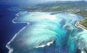
An absolutely fantastic lake near the village of Aktash, in the Altai Mountains. Firstly, it is blue in color, which is given to it by the clay lying at the bottom. Secondly, circles of different shapes and sizes constantly spread across its surface. They are created by springs gushing from the bottom and moving layers of blue clay. The water in the lake is crystal clear, and it seems shallow, although it is approximately 2 meters deep. Algae grows along the edges of the pond, some of it purple.

7. Kolyvanskoe
A large reservoir in the Altai Territory, not far from Zmeinogorsk, has a length of 4 km and a width of 3 km. It is famous for the huge rock outcrops surrounding it. In stone natural creations you can see castles, animals, human faces. The water in the lake is clear, there are a lot of fish and unique vegetation, for example, chilim nut. On the shore there is the Lazurny sanatorium, tourist centers offering entertainment for every taste, excursions and boat trips.

8. Multinskie lakes
Several delightful lakes of glacial origin on the slope of the Katunsky Range, in the Altai Republic. They are located along the Multa River, at an altitude of 1700 meters to 2200 meters. They are part of the state reserve. Nearby are the magnificent Multinskie waterfalls. Despite the great distance from civilization, this is one of the most popular tourist destinations in Altai. Be careful as there are bears in these areas.

9. Shavlinsky lakes
The group of magnificent lakes on the Shavla River is among the most picturesque in the Altai Republic. The turquoise tint of the water gives them a unique charm - a consequence of impurities of glacial turbidity. Popular tourist walking and horse riding routes, starting from the village of Chibit, pass through the lakes. The upper lake is located at an altitude of 2164 meters near the Shavlinsky glacier. The lower one is at an altitude of 1983 meters; there are many convenient tourist stops on its shore.

10. Manzherok
A small fresh lake at the foot of Malaya Sinyukha in the Altai Mountains. It has the status of a protected natural monument. Due to its shallow depth, the water in the lake warms up well and is suitable for swimming. Numerous tourist centers are located along the banks, and a year-round operation has also been built here. ski resort"Manzherok", offering relaxation and entertainment for the whole family. The lake is rich in aquatic plants, including the rather rare water chestnut.

11. Manas
One of the mountain lakes of Altai, which is of volcanic origin, lies at the foot of Mount Kabargi, at an altitude of 1520 meters. Its dimensions are small: length – 700 meters, width – 300 meters. The nature here is unique - a combination of vegetation of alpine meadows and tundra. The lake water is clean and crystal clear, but even in summer it does not exceed +18°C. Local residents consider the lake sacred and attribute life-giving powers to it. The nearest village of Edigan is 20 km away.

12. Zavyalovskie lakes
The surroundings of the village of Zavyalovo are famous not only in the Altai Territory, but also beyond its borders. Three small unique reservoirs brought them fame - salty, fresh and alkaline. They are located next to each other, surrounded by pine forest. All healing and health factors are collected in one place - ozonated coniferous air, healing mud, blue clay, salt water. On the shores of the lakes there is a tent camp and a recreation area with cozy cottages.

13. Cheybekkol
Residents of Altai call this lake, located in the valley of the Chibitka River, Dead. There are no fish or any vegetation in it. This fact is associated with the presence of mercury compounds in the reservoir. In the 30s of the 20th century, a deposit of mercury ore was actually found here. But, according to scientists, the concentration of mercury in water is normal and does not pose a threat to all living things. Cheybekkel is translated as “extended.” The length of the lake is 2.5 km, width is no more than 80 meters.

14. White
A small round-shaped freshwater lake in the Altai Territory, on the shore of the village of 8 March, is very popular among tourists. The water is warm, there is a beautiful beach on the shore, and the surrounding area is replete with picturesque landscapes. Mount Sinyukha is located nearby. In the center of the lake rises a granite island covered with fir trees and bushes. According to local legend, in the time of Elizabeth there was a factory here for the production of counterfeit coins. The lake is rich in fish. Declared a natural monument.

15. Julukul
Located on the territory of a protected biosphere reserve, at an altitude of 2200 meters. It is one of the largest lakes in the Altai Republic, 10 km long and 3 km wide. Due to the inaccessibility of these places, the ancient natural landscape, as well as unique flora and fauna, have been preserved. In particular, only here in Altai numerous gulls and cormorants nest. The lake is rich in fish, but fishing is prohibited. Nearest locality Kosh-Agach is located 100 km away.

16. Kulundinskoe
The lake, with an area of 700 km2, is the largest in the Altai Territory. This popular holiday destination is located near the village of Znamenka. It represents the remains of a sea that was here 200 million years ago. The water is salty, and the Glauber's salt of the lake is very useful, as is the mud lying at its bottom. About 150 species of birds nest on the coast, and flamingos often visit. A nature reserve has been created in the vicinity rare species animals. Hunting is prohibited, but fishing is allowed.

17. Kuchukskoe
This is the second largest lake in the Altai Territory. It is connected to Kulundinsky by a common channel on which a dam is built. The lake water is a highly concentrated salt brine, the bottom is rich in healthy mud. The reservoir is one of the country's main deposits of the natural mineral mirabilite. In addition to its healing qualities, the lake is famous for the fact that in summer it warms up to 25-26°C. There are two villages nearby: Stepnoe Ozero and Blagoveshchensky.

18. Utkul
A clean flowing reservoir is located in a picturesque area of the Altai Territory, surrounded by a pine forest and birch grove. On the coast there are the villages of Utkul and Vershinino, the recreation center "Utkul" and other tourist centers offering water activities and excursions around the lake and its surroundings. Archaeological finds in the lake area indicate that the first settlements appeared here approximately 8,000 years ago. The lake is rich in fish and is famous for its excellent fishing.

19. Raspberry Lake
The lake on the shore of the village of the same name in the Altai Territory owes its amazing hue to aquatic microorganisms that produce a special pinkish pigment. The water acquires its deepest crimson color in spring. The lake is famous not only for its fabulous view, but also for its excellent healing properties. In terms of salt concentration, its water is in no way inferior to sea water, and sulfide-silt mud has a healing effect on many diseases.

20. Blue lakes of Katun
The water in several lakes on the Katun in Altai has an amazing turquoise hue. They appear at the end of summer, when the water level in the river drops. The total area of the lakes is small - 400 m2, but they are quite deep. In winter, reservoirs do not freeze, as they are fed by springs with warm water. In spring, the water level rises, and the lakes, united, turn into one of the river branches. The age of the lakes is about 25 thousand years. The nearest village of Askat is 5 km away.

21. Uzunkel (Ulagan Lakes)
An alpine lake in the Altai Republic, surrounded by dense thickets of birch, moss, cedar and larch. Located at an altitude of 2000 meters, it belongs to the Chibitki River basin. Translated from Altai, its name means “long”. This lake stretches for 3 km and is no more than 500 meters wide. The flora and fauna in the vicinity of the lake is diverse and unique. Amateurs come here pristine nature and avid fishermen. On the shore there is a tourist center of the same name.

22. Akkemskoe
Mountain lake at the foot of Belukha in the Altai Republic. It is located at an altitude of 2050 meters and is of glacial origin. The water in the lake is cloudy, the temperature does not exceed +5°C, there are no fish. On the shore of the reservoir there is a weather station, a mountaineering camp, an Emergency Situations Ministry base, and the Vysotnik tourist center. Nearby there is another Akkem lake, called “pulsating”. This is explained by the fact that the lake is filled with water only in the spring during a flood, and then not every year.

23. Light (Swan)
The first name of the lake – Svetloye – is associated with the many springs at its bottom, thanks to which the water is incredibly clean and transparent and never freezes. And Swan Lake is called because of the whooper swans that fly here for the winter. There are only two such places in Russia - in Chukotka and in the Altai Territory. A reserve has been created on the lake to preserve this natural complex. The swans are taken care of and fed here. The nearest village is Urozhainoye, 15 km away.

24. Talmen (Taimenye)
The surroundings of this mountain lake in Altai, in the valley of the Katun tributary - the Ozernaya River, they have the status of a natural monument of a republican scale. The reservoir is located in hard to reach place, at an altitude of more than 1.5 km. The water in it is greenish in color with slight turbidity, this is a consequence of glacial feeding. The lake is rich in fish. Numerous butterflies, including very rare ones, add special color to the harsh nature. The nearest settlements are more than 100 km away.

25. Burlinskoye
In the Altai Territory there is one of the largest deposits of table salt in western Siberia. The area of the lake exceeds 30 km2, and the depth is on average 1 meter. Its salt concentration is higher than that of the Dead Sea. Nearby is the village of Bursol, its main enterprise has been engaged in salt production for more than 200 years. Salt is exported railway, the rails are laid along the bottom of the lake. The lake water changes color: when it’s hot, it’s pink, and when it’s cold, it’s steel-gray.

: Altai region And republic Gorny Altai . Both areas are vast and varied, so you need to decide what you would like to get from your holiday in Altai, then it will be easier to understand which direction to choose for your first trip.
I will share some ideas where you can go to Altai for the first time.
Altai region


The lakes in the vicinity of the villages of Zavyalovo and Guseletovo are very popular. These lakes are interesting because within walking distance, lakes with completely different compositions coexist like neighbors: salty, alkaline and fresh.
Zavyalovskie lakes are not located near Zavyalovo, as one might assume, but about 10 km from it, near the village of Svetly.

The degree of mineralization of brine in the salt lake is 115 g/l. And although the lake is small in size, rumors about its positive influence spread quickly, so it is difficult to find a free place on the shore.

On one side of the salt lake is a fresh lake with tent camp and the beach.

On the other side is Alkaline Lake with a foamy edge and many birds along the shores.

There is another alkaline lake in the village itself; it is protected on all sides by houses and forests, so here the winds do not take such liberties as in the open steppe.

Among Guseletovskie lakes, which are located a little south of Zavyalovskiye, the main purpose of the pilgrimage is Mormyshanskoe and Gorky lakes (you can read the topic on the forum).

The recreation center and tent camps are located on the banks of Gorky, it is alkaline and warm, so it is suitable for long swimming.

Vacationers go to Lake Mormyshanskoye across the road; the mineralization of this lake is slightly higher than the mineralization of the world's most famous salt lake - the Dead Sea (about 300 g/l). During the night, the salt on the bottom and shore manages to crystallize so much that it makes it slightly difficult to move without shoes.


2. Colorful lakes . You can choose others as your target in the Altai Territory, no less. And to get a general idea of this land of 1000 lakes, I advise you to take a tour of several lakes: Kulundinskoye, Bolshoye Yarovoye and the water park, Malinovoye, Zolotoe, Gorkoye-Issheechnoye, Kolyvanskoye, Beloe and Zavyalovskiye or Guseletovskiye lakes.


3. Excursions and museums. If you like excursions and museums, I suggest slightly diluting the lake tour with a historical component. Lakes Beloe and Kolyvanskoye lie near the most interesting cities.
Kolyvan is primarily known for its stone-cutting art; it was here that the famous Kolyvan vase was carved. The history of its creation is carefully preserved in Kolyvan Museum of Stone-Cutting Art.


A tour to stone cutting plant, on which the Queen of Vaz was created for 12 whole years. Nowadays, modern technologies, of course, greatly facilitate the process, but still, even now, to create a stone masterpiece, great skill and painstaking work are required.


A monolithic 11-meter section of green-wavy jasper, which became the progenitor of the above-mentioned vase, was discovered 35 km southeast of Zmeinogorsk, at the foot of Mount Revnyukhi.


It’s not easy to get to the quarry itself, but before reaching Revyukha, we’ll meet Lazurskoye field pyrite-polymer ores.


And finally, myself Zmeinogorsk. Once upon a time he was known not only in Russia, but also abroad. Half of the Altai silver was mined here, and the equipment in the mines was the most advanced. True, convicts and serfs worked in the mines in inhumane conditions, without rising from the ground to sunlight for years. He'll tell you all about it local mining museum.


4. - a resort city of federal significance at the foot of the Cherginsky spurs. By quantity sunny days in the year Belokurikha is comparable to the resorts of the Crimea and the Caucasus. Belokurikha surprisingly combines civilization and wild beauty of nature. Mild climate, healing air, picturesque rocks - all this is within walking distance from the resort area of the city. In addition, Belokurikha is the starting point of many excursion routes.

Gorny Altai
1. Many people begin to explore the Altai Mountains from the lakes. The nearest, and also warm, lakes are Manzherokskoye, Aiskoye (Aya) and the artificial reservoir Turyuzovaya Katun. Picturesque, surrounded by mountains, they attract many vacationers every day.
Lake Manzherok - perhaps the most untouched by civilization. It is a natural monument, a large number of birds nest here, many species of fish live here, however, fishing is allowed only with vouchers. On the shore of the lake, tourists will find several tourist bases, as well as a tent camp. In addition to swimming, entertainment options include catamaran riding, on land - on horses and camels, and by air - on cable car.

Aiskoye Lake surrounded by bases on all sides, bases are built to suit different tastes and budgets, so you will have to dial more than one phone number to choose the right place: comfort or economy class, youth or family vacation. If you get to the lake from the Chuysky tract, you can only cross the suspended toll bridge in front of the village of Souzga.

Turquoise Katun All summer long it retains the turquoise color of its sister due to constant filtration of water. There are beaches with entertainment around the entire lake. True, you can swim in the lake for free only by stopping at one of the bases on the banks of the Turyuzovaya Katun. The complex is located almost opposite Lake Manzherok, but on the left bank, like Aya.

2. Yes good option get to know Altai - just ride around Chuysky tract, the first time it is usually conquered up to the Seminsky Pass. The Chuysky Tract begins in Biysk at 354 km of the M 92 highway, so it is in Biysk that there is a museum of the Chuysky Tract. Here, in Biysk, the road to the right goes towards Belokurikha.

384 km - Srostki, Shukshin’s birthplace, so a museum has been opened in the village and a monument has been erected on Mount Piket.

431 km - turn to the lakes. (You can also drive to them through Belokurikha).
454 km - Aisky Bridge.
464 km - Cheremshansky spring and Cheremshansky waterfall. If we are heading to Gorny Altai, then the exit from the Chuysky tract will be to the left. You will have to walk no more than 1 km.


472 km - turn towards the village. Ozernoye and Lake Manzherokskoye.
478 km - silver source Arzhan-suu. There is also a bridge across the Katun to the tour. complex "Turquoise Katun" and to the Tavdinsky caves.


492 km - the bridge from which the trail to the Kamyshlinsky waterfall begins. (You can also get to it along the goat path, which begins on the left bank).


496 km - The Chuysky tract passes to the left bank, and along the right bank the road will go to Chemal.
502 km - s. Kamlak. Gorno-Altai Botanical Garden.

509 km - Cherginsky bison farm. You never know how long and in which direction you will have to walk, accompanied by a farm employee, until you meet the bison “face to face.”


514 km - s. Cherga. There are many picturesque places around the village.


583 km - Seminsky pass. The attraction is not limited to the stella near the road. To the right, the road goes towards the Dynamo base, along which you can climb by car almost to the very top.


3. Chemal direction is also of interest.