The Carpathians are a picturesque mountain range. Briefly about the Carpathians Carpathians ski resort where it is located on the map
The Carpathian Mountains are spread over the territory of Eastern Europe and... the Moon. Yes, mountain range with this name stretches along the southern “coast” of the lunar Sea of Rains. Perhaps in the near future tourist groups will be sent there. However, at present, only the terrestrial Carpathians are of interest to us.
The mountain system begins near the Slovak capital of Bratislava and ends near the Romanian city of Orsov. In a satellite image, the Carpathian Mountains resemble a writhing snake. Its head “bites” the Alps, and its tail is lowered into the Black Sea. It seems that the Carpathians arose as a result of some kind of vortex process like an atmospheric cyclone.
A narrow mountain chain crosses the territory of several countries in Eastern Europe. Austria, Hungary, Serbia and the Czech Republic own only it tiny pieces. Poland and Ukraine suffered much more. The largest pieces of the mountain pie are owned by Slovakia and Romania. In the latter, mountains occupy a significant part of the territory.
Scientists are still debating the name of the mountains. It is curious that in almost all the languages of the peoples inhabiting the above countries, the word “Carpathians” sounds almost the same. In some cases it literally means "mountain" or "stone wall". There is also a version that the “Carpathians” came from the tribe of carps that inhabited these places in the 1st century AD. At the same time, linguists cannot explain why this people acquired this particular name.
It should be borne in mind that the Eastern Carpathians are considered an earthquake-prone region. Very strong earthquakes have happened here. In Romania there is the so-called Vrancea seismic zone. The strength of the tremors in it reached 8.3 points on the Richter scale. Their echoes were recorded even in Finland. The disaster was most severe in 1940 and 1977. Then Bucharest suffered greatly. However, in comparison with Japan, where earthquakes occur almost daily, the Carpathians seem to be an island of complete stability.
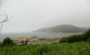
Between the Alps and the Black Sea

Southern Carpathians in late autumn
Despite its relatively modest size, the Carpathians have a complex structure. In the western part there are the Outer and Inner Western Carpathians. They are divided into 12 regions. And those, in turn, are 60 mountainous areas! Perhaps the most famous of them are the Czech Tatras. Next come the Outer and Inner Eastern Carpathians. There are fewer mountainous areas here - only about a dozen. They are adjacent to the Western Romanian, Southern, Serbian Carpathians and the Transylvanian Plateau. To simplify, the Carpathians are conventionally divided into Western, Eastern and Southern.
On a physical-geographical map, the mountain system looks like a thin strip. With a total length of the mountains of 1500 km, their width ranges from 100 to 340 km. The narrowest part is in Ukraine, and the widest is in Romania. The highest peak is Mount Gerlachovský Štit in Slovakia. Its height reaches 2654 m. The Carpathians are separated from the Alps by a narrow gap of only 14 km wide!
Only here

There is a whole collection of caves in the Lower Tatras
To get an idea of the most interesting places in the Carpathians, we'll do virtual trip in a mountainous country. Let's start from the western part, then move to the east, and from there we go down to the south. The natural border between the Czech Republic and Slovakia is the so-called White Carpathians. The reserve of the same name is located here, which is spread over the territory of two countries. Several types of orchids are found in these places! But there is a stereotype that these delicate flowers are exclusively inhabitants of the tropics.
In Slovakia there is the Sarisska Vrhovina mountain range. It is famous for its Lacnov Canyon with an unusual rock called the “Moses Pillar”. And the name “Slovak Paradise” speaks for itself. I can't think of a better place for adventure lovers. Caves, abysses, canyons and waterfalls attract them like a magnet. Besides natural objects, these places have interesting man-made attractions. For example, people go to the Slovak Muranska Planina mountains to see the ruins of the ancient Muransk castle.
The High Tatras in Poland are truly large - it is here that one of the highest points of the Carpathians is located. Tourists are very attracted here beautiful lake called "Sea Eye". Situated in an oval-shaped valley, it actually resembles a huge eye. The largest Polish waterfall, called Siklawa, is no less picturesque. The water falls here from a height of 70 m.
The Low Tatras are famous for their panoramic points, the role of which is played by the peaks of Kraljeva Golja, Habenec and Dereshe. In this area, the Demanovska valley with its caves is considered the most beautiful. It should be noted that in the local mountains there is a whole collection of all kinds of caves. One of them is called "Cave of Dead Bats". There are many centers scattered along the mountain valleys and slopes, where tourist routes.
In Hungary there is the Mátra mountain range. People come here to relax thermal springs and ride on alpine skiing. Vineyards lie at the foot of the mountains, so the region is famous for its wineries. The Börzen massif is popular among tourists. It is considered his property National Park Duna-Ipoy with a large number of springs, winding rivulets and rushing streams.
Gorgany means “stone scree”. The mountain range in the Ukrainian Carpathians has the same name. These places have long been chosen by extreme sports enthusiasts, since the area is replete with wild tourist routes. Local hits are the Manyavsky waterfall and mountain lake Synevyr, which is located on the territory of the national park of the same name.

Peles Castle in the mountains of Romania
The Southern Carpathians are also called the Transylvanian Alps. This entire beautiful mountainous country fits entirely within the territory of Romania. The highest point is Mount Moldoveanu (2544 m). Most of the country's ski resorts are located here. Don't forget that Romania is a country of castles. It's worth coming here to see with your own eyes royal castle"Pelesh" in Sinai and Dracula's castle in the town of Bran.
Climbers and rock climbers travel to Romanian Muntenia. The Unirya salt mine, which is currently a museum and balneological resort, is very spectacular. And the landscapes in Pyklele Mary look alien. Here, on an area of 30 hectares, mud volcanoes gurgle and spit slurry.
There are also places for rafting enthusiasts. For example, the Jiu River Gorge in Oltenia is one of the most popular rafting routes in Romania. Usually the Danube is associated with a calm current. However, in the Kazana Gorge the water literally boils due to the narrowness of the canyon. This spectacle is worth seeing with your own eyes.
The mountain lake Glaz Beya, located in the historical region of Banat, does not freeze even in winter, so during this period many migratory birds gather on its shores. Together with them come those who like to observe the life of birds. The lake is worth a visit just to admire it beautiful scenery and take spectacular photos.

There are places for rafting lovers in the Romanian Carpathians
And, of course, one cannot fail to mention Romanian Transylvania. The local reserve, located in the town of Zarnesti, is home to about a hundred bears rescued from captivity. Excursions around the reserve are organized for tourists. It is also worth seeing the fantastic stone columns in the Apuseni mountains, formed when basalt lava solidified. And at the former Turda salt mine, those interested can rent a boat and take a ride on the luxurious underground lake.
Nuances of the Carpathian weather

There is snow in the mountains from December to March. At other times, you can safely go to hiking
Since the Carpathian Mountains occupy a large area and are characterized by different altitudes, weather conditions can vary significantly even in the same area. The higher you go, the colder it gets. The further south you go, the warmer it is. In mountain valleys there may not be snow even in winter. The further from the Black Sea, the more continental the climate. Despite such a variety of conditions, there are nevertheless some climatic patterns.
The coldest month is January. The average temperature in the north and east of the Carpathians fluctuates around -5°C, in the south – around -3°C. However, at the tops of the mountains it can be colder - down to -10°C. By Russian standards, such temperatures are not considered frost. The average July temperature in the foothills in the north is +18°C, in the south +20°C. High in the mountains, even at the height of summer, the temperature can be no higher than +5°C. In general, the temperature regime in the Carpathians is favorable all year round.
If we talk about precipitation, the least of it falls in the east and south of the Carpathians (800 mm per year). In the Western and Romanian Carpathians their number grows to 1000 mm. In high mountain areas this figure increases by 1.5-2 times. Maximum precipitation occurs in summer. Most often it rains. The duration of snow cover in the foothills is 2-3 months. There are no glaciers or eternal snow in these places.
The moral is simple. The ski season in the Carpathians usually begins in December and ends in March. They ride at altitudes from 1000 m. This means that the rest of the year is quite suitable for hiking. At altitudes up to 1000 meters this can be done in winter. But for high mountain routes you will need warm clothes even in summer.
If you want to avoid rain, it is better to go hiking in spring or autumn. True, even in summer the risk of getting wet increases only in high mountain areas. If the route passes through the foothills or slopes at low altitudes, there is no need to worry about rain. It is enough to stock up on a raincoat and a waterproof tent.
Hiking hits
Now let’s get acquainted with popular tourist routes in those countries in which the Carpathians are located:
Czech Republic

There are up to a thousand caves in the Moravian Karst
The Krkonose Mountains are very popular in the Czech Republic. They are located on the border with Poland. Here the most popular route is the climb to Mount Snezka (1603 m). The path passes through a picturesque mountain valley with unusual name Aubrey blew. Those who wish can go upstairs using the cable car. It starts in the town of Petsi pod Snezkou.
Another popular route is the source of the Elbe. The powerful European river on which Hamburg stands originates in the town of Labski Meadow. Here you understand that all the largest rivers in the world are born from springs or formed from small streams. The starting point is the tourist center Horni Misecki. It is located near the resort town of Spindleruv Mlýn. High mountain routes along the Jeseniky ridge are also in demand. The landscapes there are considered the most beautiful in the country.
The Moravian Karst is one of the most interesting tourist sites. The length of this mountain range reaches 25 km. Its unusualness is that the mountains are penetrated by a system of caves, of which there are more than a thousand. Under the ground you can see drawings of primitive people. In the same places there is another popular site - the Macocha Canyon, which is considered the largest in Central Europe. Its depth is 138 m.
Poland
The Tatras are for the Poles what the Alps are for the French. Main tourist center This place is considered to be the city of Zakopane. It serves as the starting point for a hiking route that includes the Kościeliska Valley, the Giewont and Kasprowy Wierch Mountains, the Eagle's Path, the Five Lakes Valley, the Morskie Oko Lake and Mount Rysy (2499 m), which is the highest peak in Poland. The program usually includes a visit to the Wieliczka Salt Mine.
Slovakia

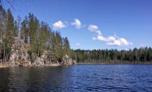
There are many lakes of glacial origin in the High Tatras
The Slovak Paradise Nature Reserve is considered a very attractive place for trekking. Hiking trails are equipped with bridges and stairs. Small rivers can be crossed using artificial fords. The trail passes by numerous waterfalls. The length of the gorge is 4 km. You can get into it from tourist center"Undergrowth" near Hrabusice. The hike refers to middle category complexity.
The Slovak High Tatras have 26 peaks, the height of which exceeds 2500 m. The most visited is Gerlachovsky Peak with a height of 2654 m. It is quite easy to climb. It is from its top that the most spectacular panoramas open.
Another popular mountain is Lomnicky Peak (2634 m). The highest Slovak weather station is located on its top. You can get to it on foot or using the cable car from Tatranska Lomnica. In clear weather, a good half of Slovakia is visible from the mountain!
The High Tatras are a place where greatest number bodies of water that were created by glaciers in the distant past. Now there are about a hundred of them. The transparency of the water in the lakes reaches 12 m. The so-called Mengus Valley stretches between the ridges. There are tourists here in any season. At the end of the valley lies the Velke Gintsovo Pleso lake. It is considered the deepest in the Tatras.
The Tatra valleys are also attractive due to their cascades of waterfalls. The Studeniy Potok waterfall is recognized as one of the most visited. Famous ones include the Obrovski waterfall, falling from a height of 20 m. No less spectacular Big waterfall. It stands out with a thirteen-meter cascade. The routes to them start from Tatranska Lomnica.
There are also tourist routes in the Low Tatras. They usually pass along the central ridge, which stretches for as much as a hundred kilometers. The ridge consists of a chain of 55 peaks, the height of which exceeds 1,700 m. Those who wish can choose either a difficult one-day high-mountain hike or moderately difficult routes where the elevation changes are small.
Romania

Neighborhood of Sinai
The places in the vicinity of the famous Romanian resort of Sinaia are very picturesque. Eat walking route, which includes not only a visit to this colorful town, but also to the famous Dracula’s castle in the town of Bran. The route starts in the city of Brasov. The program includes an ascent to the Cross of Heroes on Mount Karaiman, as well as a visit to Lake Bolboch and Omu Peak (2507 m).
Our tourist club offers the following hiking programs in the Carpathians:
- New Year in the Carpathians (accommodation in the estate and auto excursions)
- Snowy Carpathians: accommodation in estates and self-guided tours
Carpathian slopes

Ski areas in the Carpathians are located at altitudes from 800 to 2400 m
The ski season in the Carpathians lasts from December to March. Ski areas are located at altitudes from 800 to 2400 m. Many resorts use artificial snow, so the season can increase significantly.
Located in the Czech Carpathians ski resort Bila. The trails are laid on the slopes of the Zbojnicka and Javorina mountains, which are part of the Beskydy massif. The resort has been operating since 1965. It is located at an altitude of 518 m. The length of the slopes is from 700 to 1000 m.
In Poland, ski centers are located along the border with Slovakia. These are the resorts of Szczyrk, Zakopane, Szczawnica, Krynica. In Zakopane alone there are about a dozen ski centers and about 90 lifts. The largest Polish ski jump is also located here.
The largest number of ski centers are in Slovakia. Their number has exceeded a hundred, and they are all located in the Carpathians. Diverse conditions allow everyone to ride - from beginners to extreme sports enthusiasts. Resorts often have thermal springs. In winter, they organize hiking trips to the Studenovskie waterfalls, which in the cold turn into enchanting ice cascades.
In Romania, the main ski resorts are concentrated in the very center of the country in the districts of Brasov and Prahova. The Prahova Valley is located famous centers skiing Azuga, Busteni and Sinaia. The Poiana Brasov ski area also includes slopes near the town of Predeal. Ski slopes operate at altitudes from 1000 to 2400 m.
Near Carpathians

Mountain village
Ukrainian Carpathians The good thing is that they are closer than others, and a visa is not required to visit them. Eastern tip of the great European mountainous country spreads over the territory of four regions - Transcarpathian, Ivano-Frankivsk, Lviv and Chernivtsi.
The length of the Ukrainian Carpathian section is 280 m, and the width is about a hundred kilometers. On average, the mountains are low - about 900-1000 m, but there are peaks over 2000 m. These include, for example, Goverla (2061 m). It is considered the highest point of the country.
The Carpathians united more than a dozen ski resorts - Zakhar Berkut, Zhdenievo, Krasiya, Slavskoe, Pylypets and others. All of them are located in picturesque places and away from large populated areas. The visiting card of the local Carpathians is the Bukovel resort. The ski season here lasts from November to mid-April. They only ski more at Dragobrat, where sometimes the season ends in mid-May.
You can find many natural masterpieces in the mountains. These, for example, include Mount Makovitsa (984.5 m) in the vicinity of the city of Yaremche. The huge scree on its slope looks like a giant elephant coming to drink. It is often called “Elephant Mountain”. You can take a break on the banks of the Prut River. This route cannot be called a hike. It's more of an easy walk.
There is an interesting route to the place where the Princess meteorite fell. This event took place in 1866. Scientists estimated the weight of the space guest at 280 kg. They say that small fragments can still be found today. The Chernye Mlaki tract, where the cosmic catastrophe occurred, can be reached from the villages of Knyaginya or Stuzhitsa. The trail goes past mineral springs and oak trees, whose age has exceeded a thousand years. The total length of the route is 14 km.
Another route allows you to walk along the bottom ancient sea! Once upon a time, the Carpathians were truly under water. There is a marked trail from the village of Verkhovyna-Bystraya in the Transcarpathian region to Mount Plishka. It offers a view of the Uzhansky National natural park. In 1968, in these places they found the fossilized skeleton of a fish that swam here about 36 million years ago. Similar finds can be seen in Transcarpathian Museum of Local Lore in Uzhgorod Castle.

What a trip without a true friend!
The Ukrainian Carpathians are well developed in terms of tourism, so there are dozens of interesting routes. There are hikes to the mountains “High Stone”, “Parashka”, “Pikuy”, “Spitz”, “Khomyak”, “Gemba” and others. A special route is dedicated to two-thousand-meter mountains – there are six of them in Ukraine.
The Gorgan Mountains are highlighted as a separate item. There is a combined option called “Five Carpathian Passes”. He walks along the Verkhovinsky ridge. There are routes along the Marmaros massif, the Svidovets ridge, to the “Russian Way” pass - you can’t list everything. One thing is clear - you won’t get away with two days in the Carpathians. You need to come here for at least a week. Or better yet, two.
Where else could it be nicer, freer and more beautiful than in the mountains?! Limitless glades of fragrant flowers against the backdrop of an incredibly deep and clear sky. Severe stone cliffs look harmonious against the backdrop of dense emerald forests. Where in the distance the winding ribbon of a mountain stream sparkles, and there the playful water grows into a stormy and uncontrollable waterfall. With light gentle touches, the bright sun paints its pictures, understandable only to nature, with the colors of the rainbow on the transparent water canvas. It was as if stern guards surrounded the mountain peaks on all sides. Some of them are cold, covered with a white cap of snow, while others are covered with dense forests, reminiscent of shaggy bears that are hibernating. And now the bear is not sleeping, he keeps one eye open, the animal is intently watching for order. And only if you take a closer look, it immediately becomes clear that this is not the eye of a large animal, but a crystal clear mountain lake surrounded by thick mountain grasses.
Where else can you touch real clouds?! Just imagine: you are climbing to the top, and a thick white carpet appears in front of you... and a few more meters - and you seem to be rising above the world... and how can you not feel like a free bird...
And not only untouched and pure nature attracts thousands of tourists here every year. The Carpathian region is a fabulous land! A land of centuries-old traditions, hospitable and sincere people, magical villages and cities that are unlike any other in the world. To get to know this amazing region better, it’s not enough to hear someone’s impressions; it’s worth visiting! Regardless of what time of year you are going to spend your holiday in the Carpathians, be it autumn or even winter, you will get plenty of unforgettable impressions and improve your body. From all the variety of wonders, it is still difficult to choose just one, so our article will highlight individual places that are worth visiting at the beginning of your trip to the Carpathians.
1. The city of Yaremche is the capital of tourists in the Carpathian region
A small and cozy Carpathian town on the banks of the Prut River is located in a picturesque mountain basin. Although the history of the city does not even go back three hundred years, it was Yaremche that became the cradle of Carpathian culture and traditions. Extremely variegated and colorful, it combines rhythmic modernity and wise antiquity. Through hospitality local residents, their love for nature and neighbor ancient secret of the old mountains becomes accessible to every tourist.
Yaremche is especially interesting during the major religious holidays. It seems that before you is not an action familiar to the townspeople with traditions that have already been passed through more than once, but a real theater. The variety of flowers, variety of songs and actions will not leave any of the guests indifferent. A real theater with authentic actors against the backdrop of incredible landscapes can find the inflammatory Hutsul in the soul of each of us. You will remember your holiday in Yaremche for a long time.
What is worth seeing in Yaremche
- Suspension bridge over the Prut.
- Reserve with wild animals.
- Old railway bridge.
- Ancient wooden churches of the 17th-18th centuries, made in a colorful local architectural style.
- Museum of Ethnography and Ecology.
- Restaurant "Hutsulshchyna", built without a single nail.
- Pass "Pereslop".
- Dovbush rocks.
- Souvenir market.

Night view of Yaremche (Yaremcha) from a bird's eye view
2. An unforgettable vacation in the village of Polyanitsa
The next destination is the village of Polyanytsya, which belongs to the Yaremche city council. The settlement is quite modern and developed. Despite the rather Ukrainian name, the village can easily compete with the most famous ski resorts in Europe. It is next to Polyanytsya that the largest ski complex in Ukraine, Bukovel, is located.
Every tourist can be amazed not only by the incredible landscapes, but also by the cleanliness of the streets, their orderliness, and a large selection of cozy and modern private estates and hotels. Therefore, while relaxing in Polyanitsa you will collect a full cup of unforgettable impressions.
- Ski resort"Bukovel".
- Pedestrian pass "Tables" 1130
- Upside down house.

3. The picturesque Carpathian village of Yablunytsya
The village with the appetizing name Yablunytsia is located 35 kilometers from the city of Yaremche. Thanks to the moderately cold winter, snow cover remains for six months, and after large number slopes, Yablunitsa is one of the most popular resorts in Prykarpattya.
Like Yablunytsia is located in a deep cauldron, it is surrounded on all sides by the Carpathian Mountains. A fabulous time is summer, when the air is filled with sweet herbal aromas and bright juicy flowers. You just want to get into such a natural corner. Yablunitsa - relax and forget about household chores.
Without which it is difficult to imagine Yablunitsa
- Church of the Assumption Holy Mother of God XVIII century.
- Mount Hamster;
- The most high peak Ukraine Hoverla (2061 m).
- Mount Petros (2020 m).
- Yablunytsky pass.

4. City of Ukrainian customs and rituals - Kosiv
According to local legend, Kosiv is part of the heavenly land. And it’s hard to disagree with this! The land of gardening and beekeeping, the world Mecca of folk and applied arts. The entire Carpathian and mountainous region is represented in the works of local artists. Kosiv - people's encyclopedia of the Hutsul region. A visit and holiday in Kosovo is a holiday of soul and body that can go on forever.
From such pleasure, poetic lines are born by themselves:
“Smelling copper and licorice sun,
Svitankov's dew on the princess - Yalitsa,
And the clinging water of the blue spring,
This is how I will dream about Kosiv forever.”
What else is Kosovo famous for?
- Church of the Nativity of John the Baptist early XX century
- Wooden Church of the Annunciation of the Blessed Virgin Mary.
- National Park "Hutsulshchyna".
- Strutinsky Museum.
- Museum of the Liberation Struggle of the Carpathian Region.
- Kosovo market.
- Kosovo Museum of Folk Art and Life.
- Waterfall "Kosovsky Huk".
- Castle ramparts.

Kyiv Kosiv, panorama from the Ostry ridge
5. Fairytale Hutsul village - Verkhovyna
A singing land with cheerful and friendly people. Magical and mysterious place, which amazes the most skeptical minds. The region is so picturesque that it has become a favorite among writers and poets. The surrounding beauty and grandeur so impressed director Sergei Parajanov that it was here that the film “Shadows of Forgotten Ancestors,” famous throughout the Soviet Union, was shot.
Verkhovyna is like a fortress that protects the traditions of the Carpathian region on the southern side. Very bright traditions of celebrating a wedding, which takes place here for a whole week. Folk traditional costumes are just the tip of the iceberg, and all other traditions and their diversity are simply difficult to list and understand at once. But hospitable and sincere Hutsuls want the whole world to know about them. Therefore, there is no need to be shy, everything will be explained to you in the smallest detail - go ahead and relax in Verkhovyna!
What is Verkhovyna famous for?
- Museum of Hutsul Life, Ethnography and musical instruments them. R. Kumlik.
- Museum of Hutsul magic.
- House-museum “Shadows of Forgotten Ancestors”.
- "Hata flock."
- Regional Historical and Local Lore Museum of the Hutsul region.
- Museum of Applied Arts, Iltsy village.
- Verkhovyna National Natural Park.
- Written stone.

6. Silver resort of the Hutsul region - Sheshory village
A rich and luxurious Hutsul village in the Kosovo region. Without a doubt, the best way to relax is to go to the Carpathians. Sheshory is a resort famous throughout Ukraine and beyond, where the clean mountain air with the aroma of real field herbs makes you dizzy. In which you wake up to the sweet singing of birds and a soft ray of sunshine. A resort where you heal your soul and body with the help of nature. A place where you can find inner harmony.
And of course, where would we be without skis? Specially equipped ski resorts await real daredevils and extreme sports enthusiasts in Sheshory. And delicious Hutsul cuisine will quickly restore your strength.
What to see in Sheshory
- Lake Swan.
- Petrichila tract.
- Big and Small Huk waterfalls.
- Alley with American pine from the times of Austria-Hungary.
- Ridge "Brusny".
- One of the oldest Hutsul churches is the Upper Church.
- Festival of ethnic music and land art "Sheshory".

7. Skhidnytsia village
The settlement in a wide valley on the banks of a small mountain river is located in the Lviv region, Drohobych district. The former all-Union resort is still famous throughout Ukraine thanks to its Naftusya mineral water. Spring water of this type helps with liver and kidney diseases, anemia, salt diathesis, diabetes, normalizes stomach acidity, etc. Water helps in cell regeneration, so it rightfully deserves the title of “living water.”
In total, there are 38 springs and 17 wells on the territory of Skhidnitsa. In addition to water, Skhidnytsia is famous for its healing mud.
As for a resort, the village has a fairly well-developed tourist infrastructure, so guests do not need to worry about housing and prices for accommodation here for any budget. Holidays in Skhidnytsia will be a truly therapeutic and interesting pastime in the Carpathians.
What is worth seeing in Skhidnytsia
- Memorial room - museum of the discoverer of the Skhidnytsia mineral water deposit E. Stotsky.
- Route Skhidnitsa-Ugrich (10 km.) State historical and cultural reserve “Tustan”.
- Remains of the Iron Guta blast furnace.
- The Beskydy mountain range system.
- Room-museum of folk life.
- Stone Nicholas Church of the 17th century.
- Skhidnytskoe oil field.
- Skhidnytskoe mineral water deposit.
- Landscape regional park Stuzhitsa.

8. City of Skole
A small provincial town of regional significance, Skole, belongs to the Lviv region. Historical center Boykivshchyna is included in the List of Historical Populated Places of Ukraine. The settlement contains a large number of architectural and natural monuments.
The city of Skole is surrounded on all sides mountain peaks different heights, which makes it cozy and protected from cold winds. Skole is an active holiday for the whole family. The temperate and mild climate allows walking among nature on the banks of a clean river, among green and cozy forests, among fragrant herbs.
- National Natural Park "Skolev Beskids".
- Church of the Seven Sorrows, building XIX century
- Dead Lake.
- Palace of the Barons Grödley.
- Kinski Palace.
- Cave monastery XIII-XVI centuries.
- Dovbush rocks.
- Tustan Fortress;
- Church of the Great Martyr Panteleimon (Saint Paraskeva).
- Parashka.

9. Village Pylypets
Pylypets is a high-mountain village, one of the largest in the region. The famous ski resort, which belongs to the Transcarpathian region. The most visited Pylypets during the ski season. For lovers winter holiday and extreme sports there are specially equipped trails with a total length of 20 km, the longest of which is 6 km, and 7 lifts. Also, the village has an adequately developed infrastructure: hotels, estates, restaurants, rental offices, etc. For those who love home comfort, you can rent a room in the private sector.
- Church of the Nativity of the Blessed Virgin Mary;
- Mount Gymba.
- Mount Zhyd Magura.

10. Village Shayan
The real pearl of Transcarpathia is the resort village of Shayan, famous for its mineral springs. It was on the basis of these sources that one of the oldest baths, the Maramorosh Zhupas, was founded. Local water can heal and cleanse the intestines, cure stomach ulcers, and relieve urological diseases. Shayan mineral water in its properties is equal to the famous medicinal waters “Borjomi”, “Narzan”, “Essentuki”.
The developed infrastructure will allow the tourist to forget about the problems of arrangement, and the surrounding clean and incredibly picturesque nature will help to restore all lost strength. Come to the Carpathians and relax in Shayan.
Sights of the village of Shayan
- Healing springs of Marmarosha.
- Peaks Shayan, Shayanikha, Shayanchik.
- Vigorlat-Gutinsky ridge.
- Mount Loposh.
- With. Velyatino, a unique herd of buffalo, the only one in Ukraine.

Hoverla is translated from Romanian as a difficult hill. This is the name of the highest mountain in Ukraine. It rises 2061 meters above sea level. Tourists are interested in this point for its possibilities of conquering it. The first such campaign took place in 1880.
The mountain is located 17 kilometers from the border with Romania, part of the Chornohora ridge in the Carpathians. From the mountain, when it is clear, you can see the cities of Snyatyn, Ivano-Frankivsk, Kolomyia, you can see Mount Pop Ivan and the White Elephant Observatory.
The Prut River originates near Goverla. Here you can admire the cascade of waterfalls. According to legend, the Prut River arose from the tears of a young man in love. His beloved's name was Goverla. The girl's father didn't want his daughter to date a guy he didn't like, so he turned her into a mountain. But the lovers still remained together forever, this is Mount Goverla and the Prut River.
Coordinates: 48.16562700,24.49596900
Yaremche
A wonderful place to relax! At the entrance to the souvenir market there is a bridge under which a river flows and a waterfall falls. Near the market there is a restaurant made of wood, which was built without a single nail.
And what is the market itself worth - souvenirs for every taste and pocket! Colorful people, beautiful nature.
There are many hotels in the city. You can come in the summer - feel the wonderful mountain air, go to the mountains to admire nature, cool off in mountain rivers, when a stormy stream of water washes your body, no Jacuzzi is even close. There are also places for extreme sports enthusiasts to ride bikes or go kayaking. In winter, this place is suitable for lovers of skiing, snowboarding and other winter activities. Don't forget to warm up in the colorful local Kolyba! There you can eat delicious food, drink and just have a good time.
Yaremche is a great, soulful place!
What sights of the Carpathians did you like? Next to the photo there are icons, by clicking on which you can rate a particular place.
Carpathian Mountains
Karpa "you (Ukrainian Karpati, German Karpaten, Slovak Karpaty, Hung. Ká rpá tok, Roman Carpaţ i, Serbian Karpati) is a mountain system in Central Europe, on the territory of the Czech Republic, Slovakia, Ukraine (Transcarpathian, Lviv, Ivano-Frankivsk region), Hungary, Poland, Romania, Serbia and partly Austria (Hundsheimer Berge near Hainburg an der Donau and Niederösterreichische Inselbergschwelle near Mistelbach).
The absolute heights of the mountain system range from 120-400 m at the foot of the mountains to 500-800 m in the intermountain depressions and 1500-2000 m along the main ridges. Mountains over 2000 m high: Hoverla (2061 m) - the highest point in Ukraine.
The wooden Church of the Nativity of the Virgin Mary is one of the best examples of Hutsul folk architecture. Built using traditional technologies without a single nail in 1654-57. in the neighboring village Yablonitsa. The church was moved to its current location in 1780. Fragments of wall paintings from the 19th century have been preserved in the interior. Next to it there is a two-tier wooden bell tower, which houses the exposition of the church museum. In 1979, the temple was restored by architects B. Kindzelsky, G. Kruk, I. Mogitich.
Arch bridge
A large stone arched railway bridge-viaduct from Austrian times connects the two banks of the Prut River. The Yaremcha-Verkhovyna highway passes under it. The bridge was built in 1895 during construction railway Stanislav (Ivano-Frankivsk) - Yaremcha - Vorokhta - Rakhiv. The length of the bridge exceeds 100 m. It is still used for its intended purpose. Nearby there is another old Austrian bridge, which is considered one of the longest stone railway bridges in Europe (130 m).
Kosovo Bazaar
Kosovo Bazaar is a traditional Hutsul fair in the city of Kosovo, the largest in the Carpathian region. Almost all products of Hutsul decorative and applied art are presented here: ceramic dishes, carpets, embroidered clothing, iron, leather, and fur products. Souvenir products are offered at wholesale prices. Previously, the fair was held in the center of Kosovo. Now the bazaar has been moved to the eastern outskirts of the city, to a vast shopping area next to the Kutsky Bridge (Kosov-Kuty St. 48°18"59""N, 25°6"42""E). The Great Kosovo Bazaar is open only on Saturday early morning (from 4:00 to 10:00). The rest of the time, branded souvenir pavilions of the best Kosovo folk craftsmen are open in the very center of the city, next to the old Kosovo Bazaar.
Trufanets Waterfall
The Trufanets waterfall in the Ukrainian Carpathians is the highest natural waterfall in Transcarpathia. Its height is 36 meters. It can be found near the Yasinya-Rakhiv highway, 2 kilometers from the turn to Dragobrat. The waterfall is located on the southeastern slopes of the Svydovetsky ridge, on the Trufanets stream, the right tributary of the Chernaya Tisa River.
The stream originates in the subalpine zone at an altitude of 1720 meters, at the foot of Mount Bliznitsa. The length of the stream is 2830 meters.
The waterfall forms several cascades. In the forest it partially, for 230 meters, flows underground. Near the waterfall there are steps and a gazebo (gazebo), from which you can look at it up close. Trufanets Waterfall is a hydrological natural monument.
Coordinates: 48.21415000,24.30233000
Are you interested in knowing how well you know the sights of the Carpathians? .
Prut River Valley
The valley of the Prut River (the left tributary of the Danube) is one of the most picturesque places in the Carpathians. The place is distinguished by a mild climate and an amazing variety of flora and fauna. Transparent lakes, clean rivers, bubbling waterfalls and fresh air create excellent conditions for a family holiday.
Most famous resort valleys - a small cozy town of Yaremche. There are many cafes, shops, holiday homes and hotels where you can stay. Near the city there are the Probiy waterfall and the Yaremchansky canyon, the most interesting area for rafting. What is noteworthy is that there is an asphalt road along almost the entire site. Amateurs also come here in winter active recreation- forty kilometers from Yaremche there is the Bukovel ski center, which is rightfully considered the best in Ukraine.
In the river valley there are many more picturesque towns and villages that attract tourists with their hospitality, excursions and even the opportunity to pick mushrooms and berries. Among them is the village. Vorokhta, s. Mykulychyn, s. Tatarov, s. Polnitsa, s. Yablunitsa.
Coordinates: 48.45361100,24.55638900
The most popular attractions in the Carpathians with descriptions and photographs for every taste. Choose best places to visit famous places of the Carpathians on our website.
More attractions of the Carpathians

Europe between the Baltic and Black Seas - consist of en echelon mountain ranges and ridges, dissected by longitudinal and transverse valleys of the Vistula and Odra river basins in the north, the Dniester in the northeast and the Danube in the east and south. Orographically, the Western Carpathians, the Eastern Carpathians (part of which are called the Ukrainian Carpathians), the Beskids, the Southern Carpathians, the Western Romanian Mountains and the Transylvanian Plateau are distinguished. Along the entire outer side of the Carpathian arc there is a strip of foothills up to 40-60 km wide. The predominant heights of the Carpathians are 800-1200 m, the highest height is 2655 m (Gerlachovsky Štit in the Tatras).
The Ukrainian Carpathians are located on the territory of the USSR, which are located within the Lviv, Ivano-Frankivsk, Chernivtsi (Pre-Carpathian) and Transcarpathian regions (Transcarpathia). 240 km long, 100-110 km wide. The ridges extend from northwest to southeast. The axial chain is the Poloninsky-Montenegro Carpathians (the highest altitude is 2061 m - the city of Hoverla). The Carpathians have a general asymmetrical structure - a long and gentle northeastern slope and a steeper southwestern one. On the north-eastern slope there are the Vodorazdelny ridge (800-1400 m) and the system of ridges of the Skibovy Carpathians (800-1800 m), turning into the foothills. The southwestern slope decreases stepwise to the Turyan intermountain region and the Verkhnetisen depression. To the southwest of the low mountains rises the Volcanic, or Vigorlat-Gutinsky ridge (900-1100 m), the outer edge of which is adjacent to the flat Transcarpathian (Prytisenskaya) lowland (up to 120 m).
In the Carpathians, altitudinal zonation in the distribution of landscapes is clearly manifested. Forest-steppe, oak and beech-oak forests are common in the foothills; in the mountain forest belt (at an altitude of 550-800 m) - oak forests, higher (up to an altitude of 1550 m) - beech and mixed forests, at an altitude of 1500-1800 m - coniferous forests, giving way to a belt of subalpine meadows and shrubs (polonia). The soils are, respectively, mountain forest brown and mountain podzolic, and in the valleys there are mountain peat meadow soils. Fragments of the subnival belt and traces of Pleistocene glaciation are found in the Poloninsky-Montenegro Carpathians. The climate of the Carpathians is moderate, transitional from maritime to continental. Average temperatures in January are from -3 to -5°C in the Ciscarpathian and Transcarpathian regions and from -10 to -12°C in the mountains, in July 17-20°C, in the mountains up to 16-17°C. Precipitation is 770-1500 mm or more per year.
In the Cis-Carpathian foredeep, filled with Neogene molasse, three zones are distinguished: External (Bilche-Volytska), Central (Sambirskaya) and Internal (Boryslavo-Pokutska). The last two are often combined into one - the Internal Zone. The internal zone, founded on a geosynclinal flysch foundation, also sagged during the orogenic stage of development at the beginning of the Miocene with the accumulation of lower and then upper molasse; the zone is complexly dislocated into fold-scales, separated by gentle thrusts to the north. The central zone (formed in the early Miocene on a platform foundation) also has a complex internal structure. IN modern form The Inner and Central zones are large covers, far (15-20 km) overthrust to the northeast on the Outer zone (autochthonous), formed on a platform foundation in the late Miocene. The pre-Miocene foundation of the Outer Zone plunges stepwise towards the Carpathians. The thickness of monoclinally occurring upper molasse increases in the same direction.
The main part of the Carpathian arc (Outer Carpathians) is composed of a thick (more than 4-5 km) thickness of Cretaceous and Paleogene flysch, forming a system of linear folds-scales (skibs) broken by thrusts, overturned and thrust onto the Cis-Carpathian trough. Thrust amplitudes are over 20-25 km. The Outer Carpathians are a typical miogeosyncline, divided into a number of structural-facies (tectonic) zones, separated by regional thrusts: Skibovaya, Subsilesian, Silesian, Duklyansko-Chernogorskaya, Porkuletskaya and Rakhovskaya. The foundation of the Outer Carpathians is probably represented by transitional and oceanic type crust, relics of which (outcrops of lavas, porphyrites, spilites, etc.) form tectonic outliers in the frontal parts of the scales separating the internal tectonic zones of the Outer Carpathians, and are also developed in the rear suture zone. The main phase of folding here is pre-Miocene. The Outer and Inner Carpathians are separated by a strip of large deep thrust, including narrow and extended structures, the so-called. cliff zones (Marmarosh and Pieniny) with a wide development of olistostromes and tectonic melange. In the Inner Carpathians on the territory of the Ukrainian SSR, the Marmarosh crystalline massif and the Podhale zone are distinguished. The first consists of a package of nappes of Precambrian, middle and upper metamorphic rocks and shell (Bukovinian, Sub-Infrabukovinian and Transylvanian) formed in mid-Cretaceous time. The minimum displacement amplitudes are 12-15 km. The general direction of mass movement is from the Inner Carpathians to the Outer Carpathians. The Inner Carpathians also form the foundation of the Transcarpathian back trough, filled with molasse, in which the Solotvinskaya (Verkhnetysenskaya) and Chop-Mukachevo depressions and the Vigorlat-Gutinskaya volcanic ridge are distinguished. Salt dome structures with piercing cores are developed in the Solotvyno depression.
The Transcarpathian internal trough is separated from the Pannonian depression by the Pannonian deep fault (the Beregovo volcanic hill zone). Along the inner edge of the Carpathian arc runs the largest Intra-Carpathian volcanic belt in Europe, covering the Chop-Mukachevo and the inner edge of the Solotvyno depression. The volcanic belt developed in multiphases (from the early Miocene to the Pliocene inclusive), gradually migrating from the edge of the massif towards the Flysch Carpathians. Rejuvenation of volcanism also occurred in the direction from northwest to southeast, along the volcanic belt. The main centers of eruptions follow the direction of the most important longitudinal dislocations.
In accordance with the strike of the main structural elements of the Carpathians, zones with a specific set of minerals are distinguished. In the Pre-Carpathian trough - native sulfur (Dashavskoe, Kosovskoe and other deposits), oil (Borisovskoe, Bytkov-Babchenkovskoe deposits), ozokerite (Borislavskoe deposit), rock and potassium salt (Kalush-Golynskoe, Stebnikskoe and other deposits), in the Transcarpathian trough — rock salt (Solotvinskoye deposit), gas, brown coal (Ilnitskoye, Krivskoye deposits), zeolites. Neogene volcanism is associated with mercury (Bolshoy Shayan, Borkut), vein gold-base metal and barite (Beganskoye) deposits, alunites, kaolins, perlites, bentonite clays (Gorbskoye deposit). Oil deposits are known in the frontal part of the Outer Carpathians, and deposits of dolomite, limestone, marble, and raw materials for stone casting are known in the Marmarosh massif and cliff areas. In the metamorphic complex, manifestations of stratiform pyrite-polymetallic, copper-pyrite, barite and ferromanganese ores are known. Mineral waters are developed in the Carpathians, and carbonic waters are developed on the southwestern slopes of the Carpathians and Transcarpathia (Svalyava, Polyana-Kvasova deposits). In the zone of junction of the Cis-Carpathian trough with the East European Platform there are deposits of nitrogen sulfate waters. In the Inner Zone of the Cis-Carpathian Trough, brines of chloride (sulfate-chloride) composition (Morshin) are developed - a special rare type of low-mineralized waters with a high content of organic matter (Truskavets). In the Transcarpathian trough, thermal and subthermal waters of high mineralization are common, used for medicinal and thermal energy purposes.
A special place among the natural resources of the Carpathians is occupied by mineral waters, among which there are rare and highly effective medicinal properties. The most famous are the waters of Truskavets, Morshin, Svalyava, etc., on the basis of which the All-Union balneological resorts. Bottling plants are operating.
Surely many have heard about the Ukrainian Carpathians. This is a truly wonderful and charming place, perfect for a family or romantic getaway. The mountain system is located closer to the west of Ukraine and stretches for 280 km. Sometimes tourists can encounter mountains up to 2000 m high, but the highest point is Goverla - 2061 m.
It is quite natural that many people want to visit this ecologically clean area and are trying to find out in more detail where the Carpathians are. It is worth noting that the relief here is multi-tiered. Thus, there are high-mountain areas (height up to 1500 m), mid-mountain areas (up to 1300 m), low-mountain areas (up to 400 m) and foothills.
Location of the Carpathians

To more accurately understand where the Carpathians are, you need to know that they are located on the border with countries such as Hungary, Slovakia, Poland and Romania. Nevertheless, officially the mountains are located on the territory of Ukraine, namely its four regions: Transcarpathian, Lviv, Chernivtsi and Ivano-Frankivsk. Thus, from these regions you can easily and quickly reach recreation centers and take great excursions, as well as enjoy stunning scenery and fresh air. Quite often, the region under consideration is divided into two parts: Transcarpathia and Prykarpattya. In addition to which most attracts tourists, Pop-Ivan, Petros and Khomyak are just as cool and beautiful. Their height exceeds 2000 m, which is why they are considered no less powerful and interesting. It is known that people live in the mountains, but civilization does not spoil the overall picture. At the same time, there is a completely different atmosphere around: nature is practically untouched, the air is clean, sometimes heavy, and the tops of the trees touch the human gaze. In the rivers running throughout the Carpathians, there are a wide variety of fish species, which is why fishing- one of the most favorite activities of both locals and tourists.
Where the Carpathians are located is very easy to determine on the map, since it is an impressive territory, highlighted in dark brown. There is only one such site in Ukraine - in the western part of the country.
Hiking trails
Tourism in the Carpathians is most developed in the cold season. Already in mid-autumn, vacationers can visit the mountains and enjoy the first snow by climbing one of the peaks.
Most tourists have no idea where the Carpathians are, but they want to go there with all their hearts. And all because o majestic mountains there are legends, the atmosphere around fills you with strength and joy, and the stunning nature surprises. Are you planning to visit this region in the warm season? Great! A lot of entertainment awaits you: horseback riding, massage and sauna at altitude, fishing and swimming in local rivers, communicating with animals in farm yards, practicing folk crafts and much, much more. In winter, every vacationer will be able to visit the ski resort and try out the best slopes in Ukraine; taste the famous Hutsul cuisine and warming mulled wine; visit gorges covered with ice and find other entertainment. When planning a vacation, it never hurts to consider an option with mountain holiday. Just don’t forget to check where the Carpathians are.

Such settlements, like Guta, Yaremche, Yablunytsia, Synevyr, Mezhgorye and Svalyava. Many tourists dream of visiting there. In some villages you can even try locally produced water, which is popular throughout Ukraine and is considered medicinal. It is not surprising that in the Carpathians there are a huge number of sanatoriums and dispensaries, as well as recreation centers - the air and water here truly work wonders!
It is also recommended to visit famous cities: Ivano-Frankivsk, Mukachevo and Slavske. In the first of them, vacationers will be able to get acquainted with the history of this people, look at amazing sights, visit the Town Hall and much more. The Carpathians of the country Ukraine are the main attraction that people are so proud of. Arriving in Mukachevo, you should visit ancient fortresses, taste unique wine and buy souvenirs. In the village of Slavskoye you can enjoy a relaxing holiday or skiing. There is never a dull moment there, so the trip for tourists will be unforgettable.

Stunning heritage of the mountain range
When wondering where tourists are, they first of all mentally calculate the distance from their hometown to Ukrainian attractions. But they will never see those fascinating places on any map. For example, the pride of the Carpathians is the Pearl Cave, on the walls of which calcite balls are formed, somewhat reminiscent of jewelry. No less interesting will be a hike to the Enchanted Valley - a picturesque gorge with powerful rocks. It is also recommended to visit the Hanging Swamp, Stone Gate, Synevyr Nature Reserve, Lovers' Rocks and the Cave of Transparent Walls. In spring, a wonderful place for a walk will be the Daffodil Valley, which is completely covered with snow-white flowers, the diameter of which can reach 10 cm.

Treatment in the Carpathians
The Carpathians occupy an impressive place on the map, the same as in the hearts of many Ukrainians. This is why tourists come here from different countries and for various purposes. It's no secret that the Carpathian climate, fresh air, healing mineral springs help restore strength and strengthen the body. Comfortable hotels, recreation centers and other health resort establishments await their guests all year round. They are located in picturesque places, usually next to rivers and dense forests.

Pleasure for everyone
The peculiarity of the Carpathians is that almost anyone can visit them. Affordable prices and indescribably beautiful landscapes will help make your vacation or recovery unforgettable and interesting. Also, at certain periods of time, tourists will receive a pleasant surprise - discounts on trips and various bonuses. In addition, the cost of the trip varies depending on the region chosen for vacation, the number of days of stay and the intended cultural program.