Populated areas of Armenia in alphabetical order. The largest village in Armenia: village traditions
Countries:
The regions and cities of Armenia are presented to your attention.
Armenia
State in Transcaucasia. It is located in the north of the geographical region of Western Asia and the northeast of the Armenian Highlands. It has no access to the sea. It borders Azerbaijan and the unrecognized Nagorno-Karabakh Republic (NKR) to the east. In the southwest with the Nakhchivan Autonomous Republic, which is part of Azerbaijan. With Iran in the south, Turkey in the west and Georgia in the north. The population of Armenia is 3,027.6 thousand people, the territory is 29,743 km². The capital is Yerevan. State language- Armenian. The administrative-territorial units of the Republic of Armenia are: regions, communities, the city of Yerevan, which has community status, and its administrative districts. A community may include one or more settlements. The Republic of Armenia itself is a unitary state.
Capital
Yerevan
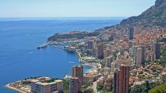
The capital and largest city in Armenia in terms of population and area. Located on the left bank (along the Araks River) part of the Ararat Valley. The population is 1.067 million people (2013). The area of the city is 223 km². Yerevan is the most important transport hub, as well as the political, economic, cultural and scientific center of the country.
Regions and cities
Aragatsotn region
Region in Armenia, in the west of the country. In the northwest it borders with the Shirak region, in the northeast with the Lori region, in the east with the Kotayk region, in the southeast with Yerevan, in the south with the Armavir region, and in the west with Turkey. Population 132,925 people. Area 2,755 km².
Cities:
- Ashtarak - city in Armenia, administrative center of Aragatsotn region. Located on the right, high bank of the Kasakh River, 20 km northwest of Yerevan. The city lies at the intersection of roads connecting three largest cities countries - Yerevan, Gyumri and Vanadzor. Ashtarak is one of the oldest cities in Armenia with numerous monuments of material culture and traditions of national life and way of life. It is famous for its districts, streets, houses, landscape. Ashtarak has still retained the flavor of an ancient and beautiful Armenian city.
- Aparan - a city in Armenia, in the Aragatsotn region, in the Aparan basin. It is located 59 km northwest of Yerevan and 42 km southeast of the Spitak railway station. Located on the Kasakh River above the Aparan reservoir at the eastern foot of Mount Aragats. The Yerevan-Spitak highway passes through Aparan. The city produces spring water "Aparan".
- Talin - city in Aragatsotn region in Armenia. Located on the Yerevan-Gyumri highway, 66 km northwest of Yerevan, 18 km north of the Karmrashen railway station.
The region is in Armenia, in the west it borders with Turkey, in the south - with Azerbaijan, in the southeast - with Vayots Dzor region, in the east - with Gegharkunik region, in the north - with Kotayk region and the capital district of Yerevan, in the northwest with Armavir region . Population 260,367 people. Area 2,096 km².
Cities:
- Artashat - city in Armenia, administrative center of the Ararat region. The fourth capital of Great Armenia. It is located 28-30 km southeast of Yerevan.
- Ararat - city in the Ararat region of Armenia. Located 48 km southeast of Yerevan. The city is named after the sacred Mount Ararat, which is located 7 km from the city, on the Ararat Plain, which is the most fertile plain in Armenia.
- Lead - city in Armenia in the Ararat region. Located on the left bank of the Vedi River, 35 km from Yerevan. Directly next to the town of Vedi is the small Goravan desert.
- Masis - city in Armenia, Ararat region. Located on the left bank of the Hrazdan River, 14 km south of Yerevan. Population - 21,376 people.
Region in Armenia. It is located in the southwest of the country, in the Ararat Valley between the Ararat and Aragats mountains, bordering on Turkey. The administrative center is the city of Armavir. The modern Armavir region was formed by the law on the administrative-territorial division of the Republic of Armenia dated November 7, 1995, as a result of the unification of the Bagramyan, Armavir and Etchmiadzin regions of Armenia. Population 265,770 people. Area 1241 km².
Cities:
- Armavir - city in Armenia, administrative center of the Armavir region. Located in the Ararat Valley, at the southern foot of Mount Aragats. Up close modern city The ruins of ancient Armavir are located - the first capital of the Armenian kingdom.
- Vagharshapat - a city in the Armavir region of Armenia, one of the most significant cultural and religious centers of the country. The city of Echmiadzin is located on the Ararat Plain, 15 km from the Echmiadzin railway station and 30 km west of Yerevan. Population 57.5 thousand inhabitants.
- Metsamor - city in Armenia in the Armavir region. The city's population is 9,870 people.
Region in Armenia. Located in the southeast of the country. The administrative center is Yeghegnadzor. Vayots Dzor region is the least populated among the regions of Armenia. Population 52,324 people. Area 2,406 km².
Cities:
- Yeghegnadzor - city in Armenia, administrative center of Vayots Dzor region. Located on the right bank of the Arpa River, 119 km southeast of Yerevan, on the Yerevan-Sisian highway.
- Jermuk - resort town in Vayots Dzor region of Armenia. Located on the Arpa River, north of the Kechut reservoir, on a plateau west of the Zangezur ridge. The distance to Yerevan is 175 km. Jermuk - balneological and climatic high mountain resort. IN Soviet era the city was a popular holiday destination, famous for its warm spring. The city produces the famous mineral table water “Jermuk”.
- Vayk - city in Armenia in Vayots Dzor region. Located 139 km from Yerevan on highway Yerevan-Sisian-Goris. Surrounded by mountains to the north and south, the city stretches for about 1.5 km along the right bank of the Arpa River.
The region in Armenia is located in the east of the country, bordering Azerbaijan. The largest region in the country, it occupies 18% of the area of the entire republic. A significant part of the territory is occupied by Lake Sevan. IN rural settlements 66.6% of the population lives. The administrative center is the city of Gavar. Population 235,075 people. Area 3,655 km².
Cities:
- Gavar - city in Armenia, the capital of the Gegharkunik region. Located on the Gavaraget River, 8 km from its confluence with Lake Sevan, 90 km northeast of Yerevan. Within the city limits, the remains of a Cyclopean fortress dedicated to the god Khaldi from the time of the Kingdom of Ararat have been preserved.
- Sevan - resort town in Armenia in the Gegharkunik region. Administrative center of Sevan region. The city is located at an altitude of 1900 m near the sources of Hrazdan.
- Chambarak - a city in Armenia in the Gegharkunik region in the upper reaches of the Getik River. Located 125 km from Yerevan near the border with Azerbaijan. Founded in 1835-1840 by Russian settlers, mainly Old Believers who fled oppression from official Orthodoxy, under the name Mikhailovka.
- Vardenis - a city in Armenia, Gegharkunik region, on the Masrik plain. It is located 168 km from Yerevan, 75 km from the regional center of Gavar, 5 km from the southeastern shore of Lake Sevan. Vardenis is located on the territory of the historical region of Sodk of Greater Armenia.
- Martuni - city in Armenia in the Gegharkunik region. Located on the southwestern shore of Lake Sevan, at a distance of 130 km from Yerevan.
Region in the central part of Armenia. The administrative center is Hrazdan. The monuments of Garni and Geghard are located on the territory of the Kotayk region. Kotayk region is the only marz in Armenia that does not have a state border. Population 254,397 inhabitants. Area 2,100 km².
Cities:
- Hrazdan - city in Armenia in Kotayk region. Located on the left bank of the upper reaches of the Hrazdan River. Located at a distance of 50 km from Yerevan. The city's population is 52,808 people. Hrazdan is one of the rainiest cities in Armenia.
- Yeghvard - city in Armenia in Kotayk region. Situated at the foot of Mount Ara on a vast terrace among orchards, vineyards and fields; 14 km northeast of Ashtarak and 19 km from Yerevan.
- Nor Achin - city in Armenia in Kotayk region. Located on the right bank of the Hrazdan River, 9 km from the Abovyan railway station and 25 km north of Yerevan. 10,198 inhabitants.
- Abovyan - city in Armenia in Kotayk region. Located 10 km northeast of Yerevan. It is a satellite city of Yerevan.
- Byureghavan - city in Armenia in Kotayk region. There is a crystal factory in the city, from which it got its name - "Byureghavan".
- Charentsavan - city in Armenia in Kotayk region. Located near the Hrazdan River, 25 km north of Yerevan. The M4 highway runs near the city, connecting Yerevan with the regions of the country Kotayk and Gegharkunik located to the north.
- Tsaghkadzor - a city in the Kotayk region of Armenia, a popular ski and climatic resort; located 50 km northeast of Yerevan and 5 km from district center, city of Hrazdan.
Region in northern Armenia. The administrative center is Vanadzor. Lori region is rich in forests. The region has a developed forestry business, as well as pig and sheep farming. In Lori region there are monuments included in the list World Heritage UNESCO - monasteries of Haghpat and Sanahin. 235,537 inhabitants. Area 3,789 km².
Cities:
- Vanadzor - the third largest city in Armenia after Yerevan and Gyumri. Administrative center of Lori region. The population of the city is 107,394 people. Located in the Vanadzor basin, between the Bazum and Pambak ridges.
- Stepanavan - a city in the center of the Lori region of Armenia. The city is named after Stepan Georgievich Shaumyan. Located on the Dzoraget River north of the Bazum Range on the Lori Plateau. The distance to Yerevan is 144 km, to Vanadzor - 30 km.
- Spitak - a city in the southwest of the Lori region of Armenia. Population 18,237 people.
- Tumanyan - a city in the west of the Lori region of Armenia. Named in honor of the great Armenian poet Hovhannes Tumanyan. The city is located on the right bank of the Debed River, 152 km from Yerevan. The city is famous for its ancient churches, especially the Kober Vank monastery complex.
- Alaverdi - a city in the northeast of the Lori region of Armenia, located 167 km from Yerevan with a population of 16,600. Within the city limits is the ancient monastery complex Sanahin. Known as the center of the copper industry of Armenia.
- Tashir - a city in Armenia, in the north-west of the Lori region, in the Lori basin. The city is located 172 km from Yerevan. 8,700 inhabitants.
- Akhtala - city in Lori region of Armenia. Located in a gorge on the left bank of the Debed River at the foot of Mount Lalvar; 10 km northeast of Alaverdi. There are forests in the surrounding area. Distance to Yerevan - 185 km.
- Shamlugh - a city in the northeast of the Lori region of Armenia. Previously it was part of the Tumanyan region of the Armenian SSR. Located on the left bank of the Akhtala River.
Region in Armenia, in the south of the country. The administrative center is Kapa. The area of the region is 15% of the territory of the entire country, and the population is 4.7%.
Cities:
- Kapan - a city in southern Armenia, the administrative center of the Syunik region. Kapan translated from Armenian means “narrow, impassable gorge.” The city is located in the east of the Syunik region in the valley of the Voghchi River on the southeastern slopes of the Zangezur ridge between its spurs - the Bargushat and Meghri ridges.
- Goris - a city in Armenia in the eastern part of the Syunik region. Located on the Goris River, 240 km from Yerevan and 70 km from Kapan. Not far from the city there is the most beautiful, one of the most important tourist monasteries in Armenia - Tatev.
- Meghri - a city in the south of Armenia, in the Syunik region. Located on the left bank of the Meghri River, at an altitude of 605 meters above sea level.
- Sisian - a city in Armenia, in the Syunik region, on the Sisian Plain. Previously, it was part of the Sisian region of the Armenian SSR and was its administrative center. Located on both banks of the Vorotan River. The city is home to the ancient Sisavan Church, and in the city center there is the Sisian Archaeological and Ethnographic Museum.
- Kajaran - a city founded in 1958 in the west of the Syunik region in Armenia. Located on the eastern slopes of the Zangezur ridge north of the Meghri ridge in the upper reaches of the Voghji River. The distance to Kapan is 25 km, to Yerevan - 356 km.
- Agarak - a city in Armenia in the southern part of the Syunik region. Agarak is located on the border with Iran, 9 km southwest of Meghri. It is located on the left bank of the Araks River on a small plain, surrounded on three sides by the slopes of the Zangezur ridge.
- Dastakert - a city in the north-west of Syunik region in Armenia. Located on the eastern slopes of the Zangezur ridge at the foot of Mount Airi and the Dastakert River. The distance to Kapan is 127 km, to Yerevan - 236 km.
Region in the northeast of Armenia. It borders with Lori region in the west, Kotayk region in the southwest, Gegharkunik region in the south, Azerbaijan in the east and Georgia in the north. The administrative center is the city of Ijevan. On the territory of the region there is large number mountain springs, rivers, lakes, mineral springs. Population 128,609 people. Area 2,704 km².
Cities:
- Ijevan - city in Armenia, administrative center of Tavush region. Located at the foot of the Ijevan ridge. Population: 20,509 people.
- Dilijan - city in the Tavush region of Armenia, mountain climatic and balneological resort. Located on the Agstev River. The city stands out for its traditional Armenian architecture. The city has been given the status of a national park.
- Bird - city in Tavush region of Armenia. Located on the left bank of the Tavush River, 211 km from Yerevan. Near the city are the ruins of the Tavush fortress.
- Noyemberyan - a city in the northeast of Armenia in the Tavush region. Located 191 km from Yerevan and 4 km from the village of Koghb on the Yerevan-Tbilisi branch. A few kilometers from the city lies the border with Azerbaijan.
- Airum - a city in the north of the Tavush region of Armenia. The city is located at the foot of the Gugarats ridge, 18 km west of Noyemberyan, 28 km northeast of Alaverdi in the neighboring Lori marz and 13 km southeast of the Georgian city of Sadakhlo. The city is located on the banks of the Debed River. High-quality peaches grow in Ayrum; they, along with Noyemberyan peaches, are the highest quality in Armenia.
The region (marz) is in Armenia, in the north of the country it borders with Georgia, in the west with Turkey, in the south with Aragatsotn region, and in the east with Lori region. The administrative center is Gyumri. Most of the Shirak region occupies the eastern half of the historical Shirak gavar, far north- Gavar Ashotsk. Shirak region is located in the north-west of Armenia. The second largest lake in the republic is located here - the Arpi lake-reservoir. Population 251,941 people. Territory area Area 2,681 km².
Cities:
- Gyumri - the second largest city in Armenia, the administrative center of the Shirak region. The city is located 126 kilometers from Yerevan, in the central part of the Shirak Basin. Modern Gyumri, which has retained the features of the ancient city, is located at an altitude of 1550 meters above sea level, in the northwestern part of Armenia.
- Maralik - a city in Armenia, in the Shirak region, in the Shirak basin. Located on the western slope mountain range Aragats, at an altitude of 1920 m above sea level.
- Artik - a city in Armenia, in the Shirak region, in the Shirak basin. It is located 105 km northwest of Yerevan, at the northwestern foot of Mount Aragats.
Capitals of Armenia
11

Yerevan
The largest Armenian city is located on the left bank of the Ararat Valley, which is not only the modern capital of Armenia, but also one of the most ancient cities in the world. On at the moment it is the largest economic and political center playing an important role in the Transcaucasian region.
10

Bjni village
Every stone in this area is imbued with the secrets of the past. The archaeological excavations carried out provided a lot of invaluable material for historians and researchers (for example, in 1929, burials dating back to the last prehistoric era - the Iron Age) were discovered.
+ 17
Ancient city of Gyumri
Arriving in Armenia, be sure to visit one of the oldest cities in the country - Gyumri, located 126 km from the capital of the state. It is the second most populous city in Armenia.
+ 8
Legends of Vayots Dzor
The historical version told by scientists is very different from the legend of the origin of the name “Vayots Dzor”, which also has supporters. Among the supporters of the latter version is the famous Armenian writer and ethnographer of the nineteenth century Gevond Alishan.
+ 5
Legends were Jermuk
The city of Jermuk is decorated not only with buildings, alleys and lakes, but also with many stories that are associated with interesting stories, ancient centuries-old traditions and beautiful legends.
+ 3
The rise of Jermuk
The heyday of Jermuk - how the city was transformed before our eyes.
+ 3
Rapid growth and development of Jermuk
Article about the growth and development of Jermuk
+ 6
Jermuk is my discovery!
Armenia is known for its natural beauty, no matter the region. I want to tell you about Jermuk. This is a wonderful town, which is part of the Vayots Dzor marz (region).
+ 88Capitals of Armenia
Ancient history Armenia has twelve capitals that have existed since the formation of Armenian statehood. The capitals of Armenia Minor, Cilicia, Sophene and Commagene are not taken into account. Perhaps future historical research, as well as archaeological discoveries, will complement the currently known material.
+ 15
Armenia itself is a very small state, both if we take into account the population (according to the 2008 census, it is 3 million less than 1,400 people), and if we take into account its area, which does not even reach 30 thousand square kilometers.
However, you should not put this indicator at the forefront, because the largest village in Armenia in terms of population can be compared with a full-fledged city, since 9,669 people live in it. We are talking about such a settlement as Vardenik, located in the Gegharkunik region of this wonderful picturesque country, and this place is also the most big village in Armenia in territory, ahead of such a large village as Sarukhan, which is home to 5,000 people. Perhaps someone will be surprised, but despite its more than modest status, Vardenik exceeds both in size and population even many Armenian cities, and as an example we can cite the tiniest city called Dastakert, which is home to only 300 people.

It is difficult to say by what exact criterion in Armenia statuses are assigned to settlements, but to this day Vardenik is considered a village. It received its name in honor of the Vardenis River, on the banks of which this large settlement was formed. As for its location relative to the nearest settlements, including the capital of Armenia, the town of Martuni with a population of 12 thousand is located 10 kilometers west of Vardenik, while Yerevan is 143 kilometers away. This settlement was founded in 1828 by refugees from the western regions of Armenia who were forced to flee the Russian-Turkish war. Another village previously existed on this site, but it was completely destroyed during the conflict. One of the main attractions of Vardenik is the Armenian Apostolic Church of the ninth century, which was repeatedly vandalized, after which it was restored by the local population.

It is noteworthy that the competition locality is the Armenian village of Akhuryan, which according to statistics has one less person. That is why in some sources it is considered the largest village in Armenia and occupies a leading position, although it is extremely difficult to determine this 100 percent. As for the location of this village, it is located in the Shirak region, one kilometer from Gyumri and 105 kilometers from Yerevan. Moreover, already 16 kilometers from it you can pass the state Turkish border, and at forty - Georgian. The main activity carried out by the local population today comes down to raising livestock and cultivating land and, in principle, the residents of Vardenik do the same.

For almost a quarter of a century, the local editorial office even published its own newspaper with the same name “Vardenik”, although its publication ceased in 1980. Another pride of this settlement is the ancient cemetery with numerous stone steles called khachkars, because some of them can even be seen in State Museum Armenian history.