One day in Krasnaya Polyana. Health Path (Rosa Khutor) Map of Krasnaya Polyana for hiking
Route
Winter is in full swing, and your legs are asking for a hike. Unfortunately, this time of year is not very suitable for long routes, and not only because the route takes longer due to deep snow. In winter, tourists in the mountains face mortal danger - avalanches. On some trails, avalanche-prone areas can be avoided, but not everywhere.
But there are also undoubted advantages: winter changes the landscape so much that a hike in summer and a hike in winter along the same route are two different hikes. You simply won’t recognize places you’ve known well since childhood in winter! But the main thing is that only in winter can the sky in the mountains be so blue, and the air so transparent and clean.
Krasnaya Polyana
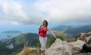
My favorite Krasnaya Polyana. I remember it as a small village surrounded by majestic ridges, which could be reached from Sochi by helicopter or along a narrow serpentine along the stormy Mzymta. Now it is one of the most fashionable and elegant ski resorts in the world (it is believed that they are also expensive, but I would argue with this statement).
The founding date of the village on the stele located at the entrance to Krasnaya Polyana is 1869, but in fact there has been a large village of mountain tribes here since time immemorial.
The village itself and its surroundings have repeatedly played an important role in history. On May 21, 1864, the Caucasian War ended here. And in 1942, at the Pseashkho and Aishkho passes, our troops stopped the German mountain division “Edelweiss” in the battle for the Caucasus.
The mountains here attract not only skiers and snowboarders. There are stunningly beautiful places here - lakes, alpine meadows, rocks, glaciers and everything that is dear to the heart of a tourist. Eat simple routes, which are well suited for beginners and families with children. Many peaks are accessible for climbing without special mountaineering training.
How to get there
Our journey starts from the Laura-Gazprom cable car, which is located 5 km from the village.
Getting to Laura is not difficult: buses from Sochi and Adler run from 6 am to 9 pm approximately every 30 minutes (about 250 rubles from Sochi), the stop is located directly at the ski lift. Travel time is more than 2 hours. It is better to leave on one of the first buses, because upon arrival you will have to go to the reserve office to get a pass. This will take about another hour.
The reserve office is located in the open-air complex (easy to find by following the signs), open from 9 am, and from Laura to it you need to walk along the river (on the opposite side of the Grand Hotel Polyana) for about 20 minutes.
The cost of the pass is 300 rubles per person per day.
The trail is periodically closed during the winter, so it's best to call the reserve to find out what rules are currently in effect.
The easiest way is to come by car, go to the reserve, and leave it in the parking lot near the ski lift for the duration of the hike (500 rubles per day).
If you travel by train, it costs more (from Sochi about 450 rubles). From the station to the cable car you will have to walk for about 20 minutes. The first train arrives at 8.47, and this is later than necessary, because you still need to go to the reserve office to get passes. If you buy passes in advance, you can immediately go to the new 3S cable car and climb to Pikhtovaya Polyana.
To climb you need to buy an excursion ticket. Price 1100 rubles (more expensive on weekends and holidays). The cable car runs from 9.00.
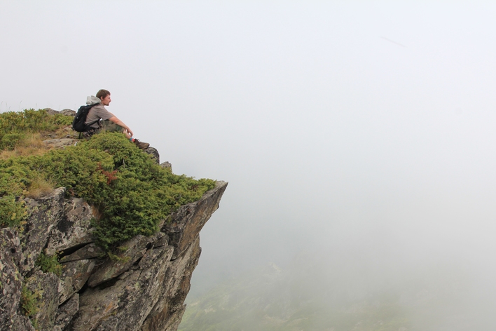
So, one early morning we went to Krasnaya Polyana for snow and beautiful scenery. We had to go to the top of Mount Tabunnaya (2351 m) in the area of the Pseashkho massif.
When we went to Tabunnaya in winter for the last time, the new cable car from Alpiki-Service did not yet exist, and we had to climb from the Psekhako plateau (1450 m). Now the lift to Pikhtovaya Polyana saves a lot of time and effort. And during our very first hike, the trails were just starting to be built, and we climbed on foot from the river, from the very bottom, gaining a total of almost 1800 m in altitude per day.
From the Psekhako plateau we went down along the rope tow, then went up to the construction site of the biathlon complex. The road the construction equipment was driving along was a mess of snow and mud, so we strapped on our snowshoes and dived into the forest.
We reached Pikhtovaya Polyana (1600 m) quite quickly. The weather was excellent - bright sun and calm. From the place where the upper cable car station is now located, the trailhead is just a stone's throw away. However, in winter the trail is a big word, because everything is covered with snow a couple of meters thick. But it’s not at all difficult to guess, since the path goes along an obvious spur, and if you just go up all the time, you’ll come out exactly where you need to go.
We climbed through a beautiful fir forest to the Bear Gate (1890 m), where the territory of the Caucasian Nature Reserve begins. The forest is already over, and you can enjoy it without interference mountain landscapes. They usually arrange a short rest here - there is a table and benches. But this is in the summer. And now only the tips of the dwarf birch trees are visible, which grow in the area between the fir forest and the alpine.
From here the trail turns left and traverses along the slope of Tabunnaya to the Bzerpa cornice - one of most beautiful places in the reserve. In the summer, alpine flowers bloom there, and now there are avalanches. Therefore, after taking a rest, we begin to climb the narrow ridge straight into the forehead. The ridge becomes steeper and steeper, and we walk the last meters taking off our snowshoes.
Having climbed up, we find a suitable place, dig places for tents and set up camp. As a reward for an active day, we get an amazing purple sunset.
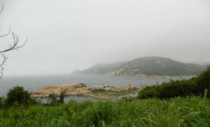
The next morning, after having breakfast with delicious porridge (and everything is delicious in the mountains), we run lightly to the top of Tabunnaya. Visibility – 360 degrees. Incredible panorama. The four peaks of Aibga, Turya Mountains and the beautiful Agepsta on one side, on the other - the majestic Chugush, Vorobyov Peak, in front are the sharp peaks of Pseasheh, below is the beautiful valley of the Pseashkho Pass, behind are the low mountain ranges that separate Krasnaya Polyana from the coast. The peaks of the Abkhazian mountains can be seen in the distance.
We packed up camp and headed back. We walked for a while, but then, when the slope became gentler, we gave up, sat down on our heels and slid down to the benches in no time. Descending through the forest was more difficult - every now and then we fell into the loose snow even on snowshoes, but we still reached Pikhtovaya Polyana quickly. A little more and we are on Psekhako.
The lift that takes you to Pikhtovaya Polyana is open until 16.30, and it is better not to be late for it. If suddenly this does happen, there is no big problem - you can walk to the cable car on Psekhako, where the slopes for evening skiing are located, so the lift is open until 23.00.
Equipment
Of course, the basic tourist kit is a backpack, a tent, a flashlight, a sleeping bag (necessarily warm, it can be down to -20°C at the top), KLMN (mug-spoon-bowl-knife), mat-mat, winter clothes (preferably water- and windproof ), good warm trekking boots.
It is advisable to have two sets of thermal underwear: a thin one for moving (it’s very hot in the sun, and you have to take off your jacket every now and then), a thick one for spending the night. Shoe covers are convenient (we call them “flashlights”) - these are things that are worn over trousers and cover the leg from foot to knee, used to prevent snow from getting into boots and under trousers.
Required: snowshoes or ski tours, sunglasses with the maximum degree of protection (snow in the sun, even without it, is really blinding), sunscreen with the highest factor (you can burn to blisters - the sun is already bright at altitude, plus reflection from the snow ), snow shovel, burner and gas.
It’s better to take a supply of food and gas - if the weather suddenly worsens, the descent from Tabunnaya to Medvezhya Gate in poor visibility becomes dangerous, you may have to wait it out.
Since the hike is only for two days, take a bottle of red wine and spices with you: mulled wine at the summit is the best mulled wine!
Winter in the mountains is wonderful, and I sincerely wish everyone to enjoy it to the fullest, but always remember to be safe.
To get as close as possible to the magnificence of the mountain cluster, you will have to walk or ride a bicycle. Here are five routes in the vicinity of Krasnaya Polyana, for which it is not at all necessary to be a laboring tourist with a huge backpack on your back.
Polikarya Waterfall
What is this. The highest waterfall in Sochi (72 m) and one of the highest in Europe. In common parlance it is called “Pants”.
For whom. Suitable for those who want to go high, see a lot, with a minimum of physical effort.
Route. Get to the Gorki Gorod resort and purchase an excursion ticket at the Polikarya Waterfall rate. The first ascent is 960 m, then transfer to the Eastern Sector gondola. Another transfer, now we are riding on open chairs, enjoying the views. A landscaped path leads from the K-13 cable car to the waterfall: for convenience, there are steps and benches to rest along the way. A pleasant coolness emanates from the waterfall: even if you don’t swim, you’ll definitely want to hang out there for a while. If it suddenly seems a bit lacking, but you still have plenty of strength and passion, returning to level +960, you can purchase an additional climb to the Black Pyramid peak.
Duration. Walking distance from the cable car is 15–20 minutes. Taking into account the time at the waterfall and travel on the ski lifts, the entire walk will take about three hours.
Efremov's horizons

What is this. An observation deck on the top of Mount Monashka (758 m), from which a panoramic view of the village of Krasnaya Polyana and the Pseashkho massif opens. Named in honor of the honorary member of the geographical society, geographer, poet and singer - Yuri Konstantinovich Efremov. In 2013, on the occasion of the 100th anniversary of his birth, on the initiative of the Krasnodar branch of the Russian Geographical Society and the residents of Krasnaya Polyana, a stele was erected in his honor.
For whom. For those who like to visit historical and memorable places.
Route. From the “Heliport” stop in the village of Krasnaya Polyana we go up Zapovednaya Street, turn onto Achishkhovskaya, and before reaching the “Achishkho” patskha about 100 meters, we go left onto a dirt road across the Beshenka River. We follow this path to the quarry (about 2 km), then climb up the picturesque forest path - we are there. The route runs through the territory of the Caucasus Biosphere Reserve, so you must purchase a pass in advance. This can be done at the ticket office of the Aviary complex, in the Alpindustria store and in the Gazprom mountain tourist center.
Duration. The entire journey back and forth at a measured pace with tea at the top will take no more than three hours.
stone pillar

What is this. The top of the Aibga ridge, the highest observation point in Sochi (2,509 m), accessible from the ski lift.
For whom. For those who want to combine the climb to Rosa Peak with an easy walk to the neighboring peak and get a glimpse of Abkhazia.
Route. Buy a walking ticket “Path to the Heights”, go up to the upper cable car station of the Rosa Khutor resort and follow the marked trail with signs. It’s better to stay to the right, as the trail will lead to the lower station of the open cable car “Crocus”, which will take you straight to the top. We walk, lose our minds at the local views, and follow the upper road back down (already on our feet) to “Rosa Peak”. It is better to clarify the operating mode of the Crocus lift in advance.
Duration. From the lower station "Rosa Dolina" with a return there, as well as leisurely walks and photography at each beautiful background The route will take at least four hours.
Cycling trip to the Pslukh springs of Narzan
What is this. A cycling route of medium difficulty, running along the Old Estonian Road, through all four resorts of Krasnaya Polyana in protected area“Cordon Pslukh” to the sources of Narzan.
For whom. For those who prefer to drive rather than walk.
Route. Rent a bike at any rental office in Krasnaya Polyana. It’s better to start from the Peak Hotel stop and then drive a little up through the rescue training base. Where the road goes sharply to the left and up, we turn right and drive along the Old Estonian Road, which will lead to the Gorki Gorod resort. On the road through Gazprom we go to Rosa Khutor, and then past the My Russia complex through two tunnels we move to the border zone, where you need to present your passport. There are 200 m left to the first source. The water, to put it mildly, is tasteless, but it seems to be very healthy. Along the way you can stop by the river and have a picnic.
Duration. Five o'clock.
Bicycle ride through the village through the old road to the Maiden's Tears waterfall
What is this. A super easy route through the quietest and calmest streets of Krasnaya Polyana, turning into an exciting ride along a wild abandoned old road.
For whom. For real area explorers
Route. From the “Heliport” stop we go up Zapovednaya Street, turn left onto Volokolamskaya and drive down with the breeze. We pass a picturesque bridge over the river, then move along Gidrostroiteley Street, before a dead end we turn sharply to the left. By steep serpentine We go to Defenders of the Caucasus in the area of the chapel and drive several kilometers along the wide side of the highway towards Adler. At the sign for the “Maiden Tears” waterfall, we take a right, pass through the barrier - and now we are on the old dilapidated road, which used to be the only link between the village and the center of Sochi. From the top there is a beautiful view of the Mzymta River valley, the new bridge and the surrounding peaks. You can complete the route near the waterfall and go back, or you can ride for some more time through a beautiful abandoned forest and get to Kepsha. Beware of rockfalls and remember that the way back will be uphill.
We are moving back along the highway. We reach the Heliport again and, if we have any strength left after a long climb, we drive up Zapovednaya, turn right onto Pchelovodov Street and rush down past beautiful houses. Then the road runs through the forest past a painted wall and leads to the Belarus sanatorium. If you really want to relax and cool down, we go into the territory, pay 300 rubles to the cashier and hang out as much as you like with two outdoor swimming pools on sun loungers, admiring the mountains. After water procedures We get out onto the same road, drive a little further forward to a steep descent down, which will be on the right, and after a couple of stops we again find ourselves at the Heliport.
Duration. Taking into account water treatments in the Belarus pools - all day. A sightseeing bike ride with only the first part of the route will take a maximum of two hours.
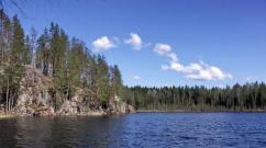
The Health Path (Rosa Khutor) is three walking routes through the forest on the slopes of Mount Psekhako. Each of them has varying degrees of difficulty. What’s good is that you don’t need to get here – the trail starts right from the resort itself. The simplest route can be done by anyone – even a child can do it. But only the most courageous can overcome the most difficult one – it’s about a two-hour journey through the forest.
Let us immediately note that in Greater Sochi Recently, various health paths and health paths have become fashionable. Therefore, if you wanted to read about the health path, which is located near Sochi, then you can do so.
The entire lower slope of Mount Psekhako, along which the Rosa Khutor health path goes, is dotted with trees. In fact, this is a magnificent southern forest, through which there is a trail stylized to resemble these almost wild places. In the warm season, the trees are covered with moss, turning the forest plush and completely green, like a fairy tale. It is worth considering that with any route you will have to go up, and if you don’t like it at all, then long routes are unlikely to suit you.
The local health trail is one of best places for a summer walk.
Routes

There are only 3 routes, each of which starts between the beach and the hotel. They also end in one place - a little upstream of the river from the entrance.
The easiest route is only 310 meters and can be completed in 10-15 minutes. If you take your time and take pictures everywhere you can, then walking this third of a kilometer can take about half an hour. It's unlikely to do more. Interesting places here is the minimum
The middle ring is 1630 meters and if you follow it, the journey will take you about an hour and a half. There will be two springs with drinking water, an observation deck, a waterfall and one yoga area. And only here there is a small lake in which you can swim. The water is really very cold. On the diagram it is marked as a font.
The Big Ring is 1970 meters. The most difficult and longest path. It will take at least two hours. There will be no font here, but there will be a glade of Strength and another area for yoga.
Want more? No one is stopping you from combining all the routes into one mega-route and visiting everything.
Where is it and how to get there
The mountain health trail is located on the territory of the steepest mountain resort Rosa Khutor. It starts from the lake beach, which can be considered the starting point.
But to go for a walk along the health path, you first need to somehow get to the mountain resort itself. There are four ways to get to Rosa Khutor:
- You can drive there yourself in your own car. First you need to get to Adler airport, and then just go straight along the A148 highway. The road is quite long - 40 kilometers from the airport, and more than 70 from the center of Sochi. But the road here is new and driving along it is a pleasure. In general, this is the most convenient way and it’s good for everyone, except that the driver will have to drive a lot and not drink alcohol. If you go on a trip alone or together, then in terms of gasoline it will be more expensive than an electric train and, even more so, a bus.
- You can get there by high-speed train Lastochka. If you travel from Sochi, this is definitely the fastest way and at the same time quite comfortable. Electric trains are not overcrowded unless something extraordinary happens in the city, so the ride will be quite comfortable. The downside is that it’s more expensive than taking a bus and you have to adjust to the schedule, which isn’t always pleasant.
- Another way to get to Rosa Khutor is, of course, by bus. Here best price, there is no strict connection to the schedule and place of start. For example, you can come from Sochi (105, 105C), from Khosta and Kudepsta and a bunch of stops along the way (105), and from Adler from the shopping center " New Century"(135). Naturally, you can get on at any stop on the A148 highway. Separately, it should be noted that in order to be guaranteed to get seats, you need to go from the initial stop (Sochi bus station or the Novy Vek shopping center in Adler).
- Theoretically, you can come to Rosa Khutor as part of an organized excursion. But there are no excursions from Sochi or Adler to the health path, so this option is not suitable for us in any case.
- If you come by train, you will need to go upstream through the entire winter resort town to Mzymta Square. The journey will take about 15-20 minutes and along the way there will be many shops where you can buy something. You can recognize Mzymta Square by the McDonald's located here. Next, cross the bridge and turn right. In a couple of minutes you will reach the next bridge. You need to turn left here, walk along the path for another minute, and then the path itself begins. You can focus on the Rosa Khutor lake beach located next to the trail.
- If you come by bus, it will stop right near Mzymta Square. What to do next is described above. Where to go for those who arrived by car themselves depends on where they managed to park it. In any case, focus on the square and McDonald's.
I have been on your path. Somehow weak. Is there something more complicated?
There will always be something more difficult.
There is a waterfall nearby, the road to which is completely untrodden. This route was once popular among tourists who loved active recreation, but now everyone goes along better routes.
You can also go to the waterfall in the Gorki Gorod resort. But not from the lift at an altitude of 960 meters, but from the very bottom. Then the path in one direction will be about 10 kilometers.
An even more difficult hike to. If you don’t care about him either, then you are enlightened and can do anything at all.
Is it worth going? (and a little about reviews)
Do you doubt whether this place is worth your attention? To be honest, I don’t know, because, unfortunately, I don’t know you. Therefore, if you like beautiful natural places and active walks, if you love forests and mountains, then it’s worth it. Numerous reviews that can be found on the Internet are extremely monotonous - they say that the place is really cool. But if in your understanding best vacation If this is lying on the sofa or, in extreme cases, on the beach, then despite all the reviews, you are unlikely to like it here.
A few points
- Admission is free
- Take food and water with you. There is nowhere to buy it here
- This is a wonderful place. And it will be just as beautiful if you don't throw trash here. Respect beauty, nature and your country
- A camera is a must on this hike. In addition to the beautiful forest, there are sometimes very cool views here.
- An interesting figure: there are a total of 919 steps on all routes. This is really a lot. For girls, walking on it is a guarantee of a very beautiful butt. That’s why this is a path to health in general.
- You should not walk along the trail in the rain and, especially, in the snow. The road can be very slippery and unsafe.
- If you like active recreation and are not here in winter time, then be sure to visit the trail. This is an amazing place. A few meters from the most perfect mountain resort in Russia, beautiful and almost wild places begin.
Put on comfortable sneakers, grab a bottle of water - and go to conquer the peaks. We talk about the most beautiful routes in the vicinity of Sochi, which can be completed in one day. Let's go!
The mountains of Krasnaya Polyana are beautiful for walks in the warm season. Dozens of simple routes that can be walked lightly are laid out at the Rosa Khutor, Gorki Gorod and Gazprom-Laura resorts, as well as around the villages of Esto-Sadok and Krasnaya Polyana. Almost all of them can be overcome by small children.
Take drinking water and snacks, sunscreen and glasses, a fleece or windbreaker with you - in the mountains, especially a few kilometers from the sea, the weather changes very quickly. Trekking poles and a seat may come in handy. A hat wouldn't hurt either.
At the Rosa Khutor resort
"To the top of the Stone Pillar"
Time: from one and a half to three hours.
Distance: from one and a half to five kilometers.
Best time for walks: from mid-June to September.
Route start: summit of Rose Peak, from there follow the signs to the Stone Pillar.
One of the most dizzying walks in Krasnaya Polyana. You can walk the entire trail from Rose Peak or cover part of the route on the Crocus chairlift. From a height of 2509 meters, a 360-degree panorama of the mountainous Caucasus opens.
Check the opening times of the cable cars so you can catch them before they close. Go out for a walk as early as possible. Don't risk getting stuck overnight in the mountains.
“To the Mendlich waterfall park”
Time: in a small circle - 30-45 minutes, in a large circle - one and a half to two hours.
Distance: small circle - 800 meters, large circle - 1700 meters.
Height difference: 90 meters.
Best time to go: from July to September.
Route start: take telecabins to the top of Rosa Peak and go down the southern slope on the Edelweiss chairlift.Two walking routes around the waterfalls of the Mendlikhi River were built in 2017.
You can see all the waterfalls in three hours - without taking into account the ascent and descent on cable cars. The paths between the waterfalls are quite steep, but are equipped with stairs. Slippery in places due to humidity. There is a cafe on the small route. A visit to the waterfall park is included in the price of the “Path to the Heights” walking ticket.
Important: the territory is border. No special permission is required, but you must have your passports and, for children, birth certificates.
"Path of Health"
Time: from 20 minutes to two hours.
Distance: small circle - 310 meters, medium - 1630 meters, large - 1970 meters.
Best time to go: from May to October.
Route start: near Rosa Beach on the banks of the Mzymta River.A classic forest path runs along the slope of Mount Psekhako. If you want to see all the beauty of this place, budget about three hours. The forest paths are equipped with signs, ladders (in total you will encounter 919 steps along the way!), wooden bridges, in the most picturesque places benches have been installed. On the way you will meet several springs and mountain streams, a small lake and two waterfalls. All the way you will be surrounded by a forest that looks like a fairy tale - with bright green moss and tall ferns.
At the Gorki Gorod resort
"Alpine Meadows"
Time: two to three hours.
Distance: four kilometers.
Best time to go: from July to September.
Route start: from the upper station of the K-3 cable car (height 2200 meters) following the signs to “Alpine Meadows”.A picturesque ecological route at an altitude of 1900−2200 meters. There are difficult sections on the trail, but it is quite passable even for small children. Rare red-listed plants grow in the Sochi alpine meadows and mountain chamois graze. Be sure to go see the atsanguars, ancient stone buildings.
"To the Bear Waterfall"
Time: 30−60 minutes.
Distance: 500 meters.
Climb: ten meters.
Best time to go: July and August.
Route start: From the upper station of the K-3 cable car, go down on the K-4 chairlift to the “Circus-2” zone.This impressive waterfall appears at an altitude of 1970-2050 meters only in the hottest months, when the snowfields melt. It is not difficult to get to it from the ski lift. Take the time to go down to its lower bowl.
Publication from All-season resort Gorki Gorod(@gorky.gorod) July 19, 2018 at 8:40 PDT
"Relic forest"
Time: one hour.
Distance: 900 meters.
Best time to go: from June to September.
Route start: from the upper station of the K-2 cable car (height 1460 meters).The eco-route at an altitude of 1400-1500 meters is laid through beech forests and equipped with gazebos, benches and observation platforms. The path is not difficult. The route can easily be combined with a walk along the Alpine Meadows eco-trail and a visit to the Bear Waterfall.
"To the Polikar waterfall"
Time: 30−60 minutes.
Distance: 800 meters.
Best time to go: from May to November.
Route start: upper station of the K-13 chairlift (height 1370 meters).This is the most impressive waterfall in all of Greater Sochi. Its height reaches 70 meters. Anyone can see this beauty, because the length of the eco-route from the cable car does not exceed 800 meters. The waterfall is located on the slope of the Aibga ridge in the area of alpine meadows at an altitude of 1450 meters.
"Circus Gorki Gorod and Aibga Ridge"
Time: all day.
Distance: five to ten kilometers.
Best time to go: from July to September.
Route start: upper station of telecabin K-3.In one summer day you can visit the most impressive places in the Gorki Gorod resort. First, take a walk along the Alpine Meadows Trail. Then take a chairlift down to the Circus 2 area, admiring the stunning views. From the ski lift it’s a stone’s throw to the Medvezhiy waterfall. And the next “armchair” will take you to the Black Pyramid mountain: only the most experienced and desperate will be able to climb to the top of 2375 meters. But even without this extreme, in just a few hours you will visit the southern forest, alpine meadows and surrounded by steep cliffs, see dizzying panoramas of the Caucasus ridge and the Achishkho, Pseashkho and Aishkho mountain ranges, and good weather— Abkhazia and the Black Sea. The highest point of this route is 2462 meters.
Resort "Gazprom-Laura"
"Bzerpinsky cornice"
Time: all day.
Distance: ten kilometers.
Best time to go: from July to September.
Route start: ascent to the mountains on the Alpika-Service cable car from Esto-Sadok or from Laura on telecabins A and A2 to the Pikhtovoy shelter.One of the most popular routes in Krasnaya Polyana. It starts from Pikhtovaya Polyana and goes along the Pikhtovoy ridge to the Medvezhye Vorota rest stop with views of Agepsta, Aishkho, Chugush, Achishkho and the village of Krasnaya Polyana. Then the road will go along the slope of Mount Tabunnaya and will lead to the Bzerpinsky cornice, the height of which reaches two thousand meters. Swim in the Bzerpi River! The route is well marked and can be easily covered in one day, but many travelers prefer to spend the night at the summit in the Kholodny camp. You must pay for the cable car ride and entry into the reserve.
Some routes pass through the territory of the Caucasian Biosphere Reserve. The pass costs 300 rubles per day for an adult, 100 rubles for a child over seven years old. Addresses where you can purchase a pass are published on the reserve’s website. The fine for violators is up to four thousand rubles.
"To the rivers Achipse, Assara and Rudovaya"
Time: four to five hours.
Distance: 10−14 kilometers.
Climb: 250 meters.
Best time to go: from March to November.
Route start: aviary complex at Gazprom.An easy and picturesque walking route for tourists of any age. You will walk across the suspension bridge over the Achipse River, wade across the Assaru River, see a trout lake, and cross the Vylomannaya Balka stream. And also - take a walk through the beech and hornbeam forest, admire the rhododendrons and see how walnuts grow. Take a look at the enclosure complex where animals living in the North-West Caucasus live. The route passes through the reserve; you must issue a ticket.
The routes passing through the territory of the reserve are not open to tourists all year round. Typically, walks are allowed from mid-June until the first snow around the end of October. If you come in spring or autumn, you should not go on any mountain routes in rain or snow. The best time is from the second half of June to the beginning of July, when rhododendrons bloom.
Around Krasnaya Polyana
"To Keivu Falls"
Time: three to four hours.
Distance: ten kilometers.
Climb: 500 meters.
Best time to go: June-September.
Route start: from “Skoropyatka” - a camp site of the Ministry of Defense, where you need to find concrete steps, walk past the barnyard and climb over a low fence.The route begins in the village of Krasnaya Polyana and immediately leads into the forest. The trail is well-trodden and easily passable, but you will have to overcome several noticeable climbs and inclines. Linger at the observation deck overlooking the Aibga Ridge and the Sochi Olympic ski jumps. The main goal of the walk is a picturesque multi-stream and always energetic waterfall, falling from a high cliff, which bears the name of Elmar Keivu, a famous Krasnopolyansk guide-enthusiast.
"Efremov's Horizons, the Monashka River and Medoveevka"
Time: five o'clock.
Distance: 12 kilometers.
Best Season: from June to November.
Route start: in the village of Krasnaya Polyana on Zarechnaya Street (you need to go up Zapovednaya Street to the bridge over the Beshenka River), from there - strictly west.An easy scenic route. From the vantage point of Efremov (local historian and researcher of Krasnaya Polyana, whose memorial you will meet on the route) on Mount Monashka you can see the village of Krasnaya Polyana, the Aibga ridges, the Pseashkho and Aishkho massifs. Then you will cross the Monashka River, walk through the beech-chestnut forest, and wade the Medoveevka River. If you wish, you can conquer the route on a mountain bike. Descents and ascents alternate and are not tiring. You need to buy a ticket to the reserve.
Remember that in protected areas you cannot light fires, litter, or go beyond the marked trails; collecting plants, herbs, berries, mushrooms, and even water from natural reservoirs is prohibited.
“To the Khmelevsky lakes, dolmens, the Achishkho ridge and the Achipsinsky waterfalls”
Time: all day.
Distance: 10−20 kilometers.
Climb: 1200 meters.
Best time to go: from the end of June to September.
Route start: in Krasnaya Polyana on the left bank of the Beshenka River.One of those day walks that feels a lot like a real hike. At the very beginning of the walk you will see megalithic dolmens, which are more than three thousand years old. After crossing the river over the bridge, you will find yourself at the font. Then a steep climb leads through a beech forest to the Round Glade at an altitude of 1460 meters. Further you will find yourself on the shore of Lake Mirror, from where a 360-degree panorama opens from a height of 1900 meters. Walk along the circus of the Achishkho ridge to see the three-cascade Achipsinsky waterfalls. On way back at an altitude of 1700−1750 meters you will see the picturesque Khmelevsky lakes, surrounded by alpine glades, rocky ledges of Wolf Teeth, the ruins of an ancient atsanguar, Rocky Mountain, Sugar Pseashkho peak, as well as the border of Abkhazia and the Black Sea. Having completed this route, you will understand whether you are ready for real multi-day hikes.
You can complete all the walks described on your own. Or you can do it with a guide. He will help you choose the best route for you and tell you a lot of interesting things along the way.
On the territory of Krasnaya Polyana and its environs there are many tourist routes, from one-day hikes to serious 3-5 day hikes. Everyone can choose the most suitable option for themselves. You can go on simple hikes either without an instructor or with one.
Here is a map of summer routes that will be most convenient for those who are new to the Krasnaya Polyana mountains and want to get acquainted with the area. However, for professional travelers, topographic maps are more suitable.
 Map compiled by the RiderHelp team
 List of tourist routes in Krasnaya Polyana. Each of them is discussed in more detail below.
- Achishkho Ridge – 3-4 hours
- Keiva Falls - 3-4 hours
- Efremov's horizons - 2-3 hours
- Cornice r. Bzerpi - 1-2 days
- Mountain Stone Pillar on Rosa Khutor - 2-3 hours
- Polikarya Waterfall (Pants) - 2-4 hours
- Health path to Rosa Khutor - from 15 minutes to 2 hours
- Achipsinskaya fortress - 2-3 hours
- Kharginsky forest and waterfall at Rosa Khutor - 5-6 hours
- Camp Kholodny and Semiozerye - 2-3 days
- Mount Achishkho and Lake Khmelevskogo - 1-3 days
- Lake Kardyvach – 2-4 days
If you are a novice traveler or simply do not want to spend several days on a hike, then day hikes, or “weekend hikes,” are perfect for you!
Mountain peaks, waterfalls and incredible views will help you rejuvenate and recharge your batteries. Such routes are suitable for family hikes with children and for unprepared tourists. The only requirement for such a walk is the presence of special shoes and clothing for trekking.
Achishkho Ridge

The route begins in the village of Krasnaya Polyana. Unique nature mountain range Achishkho with its alpine meadows and lakes will not leave you indifferent. For a novice tourist, this is an excellent opportunity to get acquainted with practically all the main high-altitude natural and climatic zones of the mountainous Black Sea region. You will need to go up to the starting point of the route by car. You can start the walk from the Khmelevskoye lakes, then go through the horizon 1822. Along the ridge you can walk to Lake Zerkalny, where you will have the opportunity to stretch out and bask in the sun, at an altitude of 1900 m above sea level. Then we go down through the Round Glade, Sosnovaya Rock, and back to Krasnaya Polyana. During the hike you will be able to see the famous rock outcroppings of Wolf's Teeth, the ruins of Atsanguar, and stand on the top of Mount Skalistaya!
At the top you can fully admire the Peaks of the Main Caucasus Range, the Gagrinsky Range (Republic of Abkhazia) and the Aibginsky Range, as well as the Sugar Pseashkho Peak and views of the Black Sea.
This is a completely safe route for all ages, with connections everywhere. Most best route in the Krasnaya Polyana area for family hikes.
Equipment:
Keiva Falls

Keivu Waterfall is located within walking distance from the village of Krasnaya Polyana. The route is suitable for most nature lovers. And it starts from the recreation center of the Krasnaya Polyana municipal district. The asphalt road begins with a smooth ascent and turns into a forest one. Beginning tourists will not be able to get lost, since there is only one path to the waterfall and does not branch anywhere. During the ascent, panoramic views of Krasnaya Polyana open up. This waterfall is also known for the fact that it does not dry out at any time of the year. The road from the camp site itself will take about an hour, and the elevation gain will not exceed two hundred meters. Right there, at the waterfall or going down below, you can take a break with tea or coffee and begin your descent to Krasnaya Polyana along the path, where you will also be accompanied by beautiful views to the mountains.
Equipment: with sportswear and weather-appropriate shoes, storm jacket, backpack, snack, water.
Price: free of charge, but you need to get to the Ministry of Defense camp site and take your passport with you if you go not along the bypass path, but from the camp site. If you want to go with a guide, then Krasnopolyansky Mountain Club and Adventure Workshop lead here.
Efremov's horizons
 Efremov’s Outlook - The name “Efremov’s Outlook” was given to Mount Nun in honor of Yuri Konstantinovich Efremov, geographer, poet, writer, honorary member of the Russian Geographical Society. The horizon itself was discovered by surveyors, but it was Efremov who discovered it for people. The route runs along a dirt road within the Caucasian Biosphere Reserve. Mount Monashka (height 758m) is located 2 km southwest of the center of Krasnaya Polyana and 750m from the right bank of the Mzymta River. It’s easy to get there, across the road “to Medoveevka” and the valley of the Beshenka river. It is from Mount Monashka that a magnificent view of Krasnaya Polyana, its surroundings and the Pseashkho massif opens up.
Price: 300 rub. for a pass to the reserve and optional guide services.
Mount Tabunaya and Bzerpinsky cornice
 The route passes through the territory of the Caucasian Biosphere Reserve, and therefore, before entering the route, you must stop by the Aviary complex (3 km from the center of Krasnaya Polyana) and get a one-time pass. Mount Tabunaya (2351 m above sea level) is one of the peaks of the Bzerpi massif, located 15 kilometers from the village of Krasnaya Polyana.
The beginning of the route is the Gazprom cable car station Pikhtovaya Polyana (1700 m above sea level). further through the Bear Gate pass, and the Bzerpi cornice (2100 m above sea level), where you can rest a little and go to the top of Mount Tabunnaya.
At the top you can fully admire the Peaks of the Main Caucasus Range, the Gagrinsky Range (Republic of Abkhazia) and the Aibginsky Range, as well as the Sugar Pseashkho Peak and views of the Black Sea.
A route for one-day walks for all people with average physical fitness. An opportunity to look at Krasnaya Polyana through the eyes of pioneers from the passes, which, like a magnet, attract the eyes of everyone who comes to Krasnaya Polyana.
Equipment: o clothes for the weather, storm jacket, small backpack, closed shoes with thick tread, glasses, hat, sunscreen, snack, water.
Price: 300 rub. per day - pass to the reserve.
Guide services: usually from 2000 rubles. per person
Experienced tourists can go on their own, as the trail is equipped and not difficult.
Stone Pillar
 Great hiking for the whole family. Dot mountain range Aibga, located between the Mzymta and Psou rivers. The peak naturally separates the eastern and western slopes of the ridge.
The route starts from the upper station of the Rosa Khutor cable car, Rosa Peak. The lift will take you to Rosa Peak, which offers an excellent view of the Caucasus Mountains. This is also where the trail to the Kamenny Pillar peak begins. You can make your way easier and get just to the bottom station of the Crocus chairlift, which will take you to the very high point route - the peaks of the Stone Pillar (2509 m above sea level), however, you will still have to descend on your own.
Equipment: o clothes for the weather, storm jacket, small backpack, closed shoes with thick tread, glasses, hat, sunscreen, snack, water.
Price: 1300 rub. for the lift; If desired, you can take a tour guide.
Polikarya Waterfall

Polikarya Waterfall (also known as “Pants”) is one of the highest and most picturesque waterfalls in Sochi, about 70 meters high. At the same time, it is in relatively easy accessibility for tourists. A year ago, in June 2016, this excursion route became available to mass tourists. Thanks to the launch of the resort's cable cars in the Eastern Sector, the route to the finish point has become as easy as possible. The journey to the waterfall now takes no more than 30 minutes. And, despite the fact that on May 20th Home cable car closed for routine maintenance until Upper Town, to an altitude of 960 meters, a free shuttle runs. From there, guests transfer to the gondola cabins of the road "K-10", then to the chairlifts - "K-12" and "K-13" and get to the starting point of the walking route to the waterfall. However, for guests who like long walking routes, there is always the opportunity to walk to the waterfall from 960 meters above sea level (the path takes about 2 hours one way).
The height of the waterfall is about 70 meters, it is located between 1450 and 1600 meters above sea level vertically. However, now the name of this waterfall is more often found as “Polikarya”, and Krasnopolyans call it “Pants”. He received this nickname because of two identical trouser-leg streams, which seethe most strongly in late spring - early summer, during the period of active snow melting.
Rosa Khutor Health Path
 The ecological route “Path of Health” runs along the picturesque slope of Mount Psekhako and is located in the Rosa Khutor resort. The “Health Path” begins at Rosa Beach. The length of the trail is more than 3300 meters with a height difference from 580 to 732 meters above sea level. The route is equipped for tourists and has signs. You have to cross 13 mountain streams, and there are two waterfalls nearby. Along the entire route there are 25 places for rest, 3 observation platforms, and one plunge pool.
Price: for free.
Achipsinskaya fortress

A classic, but at the same time uncomplicated route, the beginning of which is located right in the village, at the fork near Gazprom. You can go there on your own, or with a guide to make it more interesting. The climb to the ruins of the ancient Byzantine fortress of the 9th century takes no more than half an hour, and then you can walk through the picturesque forest and go down to the beginning of the village of Esto-Sadok.
Price: free or 2000 rub. as part of an organized group with Adventure Workshop guides.
Kharginsky forest and waterfall at Rosa Khutor
This is a new hiking route to Rosa Khutor, which starts from Rosa Plateau, passes through the resort trails, then continues along a forest road and leads to a small picturesque waterfall and forest lake. During the route, the guides will tell you about Olympic venues the resort and its history, and in the forest area they will introduce guests to local endemic plants.

Since the route passes through the border zone, you can only go there with resort guides by appointment.
Price: 500 rub. per person. But don’t forget that you still need to climb Rosa Plateau or buy a special “cable car + hike” tariff for 1000 rubles.
Camp Kholodny and Semiozerye
Uncomplicated and popular route a trip with 1 or more overnight stays. First, take the Gazprom cable car to an altitude of 1660 m, then walk along an equipped trail to an altitude of 2300 m. Beautiful views of Krasnaya Polyana and the mountain peaks surrounding you.

Price: 300 rub. per day - pass to the reserve. Can be purchased at the aviary complex.
Transfer: cable car GTZ Gazprom, 800 rub. (to Pikhtovaya Polyana 1660 m)
Experienced tourists can go on their own, but with a guide it will be obviously easier and more interesting if you are here for the first time.
Mount Achishkho and Lake Khmelevskogo
The most famous and popular route in Krasnaya Polyana. This is where many now experienced tourists started. Relatively easy road, beautiful views from many observation platforms and swimming in a mountain stream. And also the opportunity to drive up to mountain path by car. This hike is suitable for those who want to discover mountain hiking. The route is also good because you can go there either with or without an overnight stay, depending on your time and wishes.
Price: 300 rub. per day - pass to the reserve. You can buy it in Polyana at the aviary complex.
Transfer: 5000 rub. for a UAZ for 5-7 people. to the Khmelevskoye lakes (one way). Or walk.
Guide services: usually 7-8 thousand rubles. per group per day or cost per person per day/per hike.
Lake Kardyvach
The pearl of Krasnopolyansk routes, mountain lake Kardyvach has attracted tourists and photographers for decades. You need to plan your trip to Kardyvach in advance, since to visit you need to get a border pass, which takes about a month.