Why are the Kuril Islands so important for Russia? Kuril Islands
The name of the Kuril Islands does not come from the “smoking” volcanoes. It is based on the Ainu word “kur”, “kuru”, meaning “man”. This is how the Ainu, the indigenous inhabitants of the islands, called themselves, this is how they presented themselves to the Kamchatka Cossacks, and they called them “Kuril Islands”, “Kuril men”. This is where the name of the islands came from.
The Ainu gave a suitable name to each island: Paramushir means “wide island”, Kunashir - “black island”, Urup “salmon”, Iturup - “big salmon”, Onekotan - “old settlement”, Paranay - “big river”, Shikotan - “ best place." Most of the Ainu names have been preserved, although there were attempts on both the Russian and Japanese sides to rename the islands in their own way. True, neither side sparkled with imagination - both tried to assign serial numbers to the islands as names: First Island, Second, etc., but the Russians counted from the north, and the Japanese, naturally, from the south.
The Russians, like the Japanese, learned about the islands in the middle of the 17th century. The first detailed information about them was provided by Vladimir Atlasov in 1697. At the beginning of the 18th century. Peter I became aware of their existence, and expeditions began to be sent to the “Kuril Land” one after another. In 1711, the Cossack Ivan Kozyrevsky visited the two northern islands of Shumshu and Paramushir; in 1719, Ivan Evreinov and Fyodor Luzhin reached the island of Simushir. In 1738-1739 Martyn Shpanberg, having walked along the entire ridge, put the islands he saw on the map. The study of new places was followed by their development - the collection of yasak from the local population, the attraction of the Ainu to Russian citizenship, which was accompanied, as usual, by violence. As a result, in 1771 the Ainu rebelled and killed many Russians. By 1779, they managed to establish relations with the Kurils and bring more than 1,500 people from Kunashir, Iturup and Matsumaya (present-day Hokkaido) into Russian citizenship. Catherine II exempted all of them from taxes by decree. The Japanese were not happy with this situation, and they forbade the Russians to appear on these three islands.
By and large, the status of the islands south of Urup was not clearly defined at that time, and the Japanese also considered them theirs. In 1799 they founded two outposts in Kunashir and Iturup.
At the beginning of the 19th century, after an unsuccessful attempt by Nikolai Rezanov (the first Russian envoy to Japan) to resolve this issue, Russian-Japanese relations only worsened.
In 1855, according to the Treaty of Shimoda, the island of Sakhalin was recognized as “undivided between Russia and Japan”, the Kuril Islands north of Iturup were the possessions of Russia, and the southern Kuril Islands (Kunashir, Iturup, Shikotan and a number of small ones) were the possessions of Japan. Under the treaty of 1875, Russia transferred all the Kuril Islands to Japan in exchange for an official renunciation of claims to Sakhalin Island.
In February 1945, at the Yalta Conference of the Heads of Power of the Anti-Hitler Coalition, an agreement was reached on the unconditional transfer of the Kuril Islands to the Soviet Union after the victory over Japan. By September 1945, Soviet troops occupied the Southern Kuril Islands. However, the Instrument of Surrender, signed by Japan on September 2, did not directly say anything about the transfer of these islands to the USSR.
In 1947, 17,000 Japanese and an unknown number of Ainu were deported to Japan from the islands that became part of the RSFSR. In 1951, Japan began to make claims to Iturup, Kunashir and the Lesser Kuril Ridge (Shikotan and Habomai), which were given to it under the Shimoda Treaty in 1855.
In 1956, diplomatic relations between the USSR and Japan were established and a Joint Agreement on the transfer of the islands of Shikotan and Habomai to Japan was adopted. However, the actual transfer of these islands must be made after the conclusion of a peace treaty, which has not yet been signed due to the remaining Japanese claims to Kunashir and Iturup.
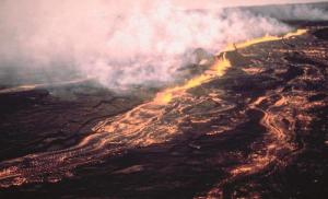
The Kuril Islands chain is a special world. Each of the islands is a volcano, a fragment of a volcano, or a chain of volcanoes fused together at their bases. The Kuril Islands are located on the Pacific Ring of Fire; in total there are about a hundred volcanoes, 39 of which are active. In addition, there are many hot springs. The ongoing movements of the earth's crust are evidenced by frequent earthquakes and seaquakes, causing tidal waves of enormous destructive power - tsunamis. The last powerful tsunami was generated during the earthquake on November 15, 2006 and reached the coast of California.
The highest and most active of the Alaid volcanoes on Atlasov Island (2339 m). Actually, the entire island is the surface part of a large volcanic cone. The last eruption occurred in 1986. The volcano island has an almost regular shape and looks incredibly picturesque in the middle of the ocean. Many find that its shape is even more correct than that of the famous one.
Near the eastern underwater slopes of the Kuril Islands there is a narrow deep-sea depression - the Kuril-Kamchatka Trench with a depth of up to 9717 m and an average width of 59 km.
The relief and nature of the islands are very diverse: bizarre shapes of coastal rocks, colorful pebbles, large and small boiling lakes, waterfalls. A special attraction is Cape Stolbchaty on Kunashir Island, rising like a sheer wall above the water and entirely consisting of columnar units - giant basalt five- and hexagonal pillars formed as a result of the solidification of lava, poured into the water column, and then raised to the surface.
Volcanic activity, warm and cold sea currents determine the unique diversity of flora and fauna of the islands, strongly elongated from north to south. If in the north, under harsh climate conditions, tree vegetation is represented by shrub forms, then on the southern islands coniferous and deciduous forests with a large number of vines grow; Kuril bamboo forms impenetrable thickets and wild magnolia blooms. There are about 40 endemic plant species on the islands. There are many bird colonies in the Southern Kuriles region; one of the main bird migration routes passes here. Salmon fish spawn in rivers. Coastal zone - rookeries for marine mammals. The underwater world is particularly diverse: crabs, squids and other mollusks, crustaceans, sea cucumbers, sea cucumbers, whales, killer whales. This is one of the most productive areas of the World Ocean.
Iturup is the largest of the Kuril Islands. On an area of about 3200 km 2 there are 9 active volcanoes, as well as the city and unofficial “capital” of the islands due to its central location, Kurilsk, founded in 1946 at the mouth of the river with the “speaking name” Kurilka.
Three administrative districts with centers in Yuzhno-Kurilsk (Kunashir).
Kurilsk (Iturup) and Severo-Kurilsk (Paramushir).
Largest island: Iturup (3200 km 2).
Numbers
Area: about 15,600 km2.Population: about 19,000 people. (2007).
Highest point: Alaid volcano (2339 m) on Atlasov Island.
Length of the Great Kuril Ridge: about 1200 km.
Length of the Lesser Kuril Ridge: about 100 km.
Economy
Mineral resources: non-ferrous metals, mercury, natural gas, oil, rhenium (one of the rarest elements in the earth's crust), gold, silver, titanium, iron.
Fishing for fish (chum salmon, etc.) and sea animals (seal, sea lion).
Climate and weather
Moderate monsoon, severe, with long, cold, stormy winters and short, foggy summers.Average annual precipitation: about 1000 mm, mostly in the form of snow.
A small number of sunny days occur in autumn.
Average temperature:-7°C in February, +10°C in July.
Attractions
■ Volcanoes, hot springs, boiling lakes, waterfalls.■ Atlasov Island: Alaid volcano;
■ Kunashir: Kurilsky Nature Reserve with Tyatya Volcano (1819 m), Cape Stolbchaty;
■ Rookeries of fur seals and seals.
Curious facts
■ In 1737, a monstrous wave about fifty meters high rose in the sea and hit the shore with such force that some rocks collapsed. At the same time, in one of the Kuril Straits, new rocky cliffs rose from under the water.■ In 1780, the ship “Natalia” was thrown by a tsunami deep into the island of Urup, 300 meters from the coast. The ship remained on dry land.
■ As a result of the earthquake on the island of Simushir in 1849, the water in the springs and wells suddenly disappeared. This forced the inhabitants to leave the island.
■ During the eruption of the Sarycheva volcano on the island of Matua in 1946, lava flows reached the sea. The glow could be seen 150 km away, and ash fell even in Petropavlovsk-Kamchatsky. The thickness of the ash layer on the island reached four meters.
■ In November 1952, a powerful tsunami hit the entire coast of the Kuril Islands. Paramushir suffered more than other islands. The wave practically washed away the city of Severo-Kurilsk. It was forbidden to mention this disaster in the press.
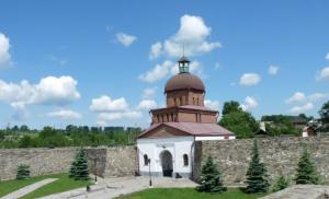
■ On Kunashir Island and the islands of the Lesser Kuril Ridge, the Kurilsky Nature Reserve was created in 1984. 84 species of its inhabitants are listed in the Red Book.
■ In the north of the island of Kunashir there grows a patriarch tree; it even has a proper name - “Sage”. This is a yew, its trunk diameter is 130 cm, it is believed that it is more than 1000 years old.
■ The notorious tsunami of November 2006 was “marked” on the island of Shikotan, according to instruments, with a wave 153 cm high.
The Kuril archipelago is a chain of 56 large and small islands of volcanic origin. They are part of the Sakhalin region and stretch from north to south from Kamchatka to the shores of the Japanese island of Hokkaido. The largest of them are Iturup, Paramushir, Kunashir and Urup, only three are inhabited - Iturup, Kunashir and Shikotan, and besides them there are many small islands and rocks that stretch for 1200 km.
The Kuril Islands are interesting, first of all, for their nature. Volcanoes (most of which are active), lakes, thermal springs, diverse landscapes and national parks are a real paradise for photographers and other lovers of beautiful views.
There is practically no infrastructure on the islands; transport, hotels and catering are still not easy here, but the unique nature and landscapes compensate for all the inconveniences.
How to get there
Getting to the islands of the Kuril archipelago is difficult, but getting out is even more difficult. All Kuril transport - planes and ferries - is dependent on weather conditions, and in the Sea of Okhotsk they are not always favorable. Flight delays are calculated not in hours, but in days, so when planning your trips, it is always worth setting aside a few spare days for possible waiting.
You can get to Paramushir (Northern Kuriles) from Petropavlovsk-Kamchatsky by boat or helicopter. The South Kuril Islands, which are more popular among tourists, are reached from Sakhalin - by plane from Yuzhno-Sakhalinsk or by ferry from Korsakov.
By plane
Flights from Yuzhno-Sakhalinsk to Yuzhno-Kurilsk on Kunashir Island and to Kurilsk on Iturup Island are operated by Aurora Airlines. According to the schedule, planes depart every day, but in reality they depend on the weather. Travel time is 1 hour 20 minutes one way, ticket prices start from 400 USD round trip. Keep in mind that tickets should be purchased in advance as they sometimes sell out months in advance. Prices on the page are as of November 2018.
By ferry
The ferry "Igor Farkhutdinov" from the port of Korsakov departs on schedule twice a week to the islands of Kunashir, Shikotan and Itupur (this is the same route with several stops). The schedule is very approximate, so you cannot buy tickets online in advance, and sailing times vary from a few hours to a day. Tickets are sold at the ticket office of the Korsakov port in Yuzhno-Sakhalinsk; they can no longer be purchased at the port itself.
You can only buy a one-way ticket; return tickets begin to be sold after departure on the ship itself (you need to sign up in the queue to buy).
The ferry takes about 20 hours, the conditions there are not the most luxurious, but quite decent: four- and double-bed cabins, as well as luxury cabins with amenities in the room, there is an inexpensive restaurant and bar on board (prices are already higher there), as well as a small library . Ticket prices start from 2800 RUB per person.
When crossing from Sakhalin to Kunashir there is usually a lot of swaying, and many passengers complain of seasickness, so it’s worth having anti-sickness pills with you just in case.
Obtaining an entry permit
To visit the Kuril Islands you need a pass to the border zone; it is issued by the Sakhalin Coast Guard branch of the FSB in Yuzhno-Sakhalinsk. The application can be submitted on weekdays in the morning from 9:30 to 10:30 (you only need a passport and a photocopy of it, which can be made on the spot), the pass will be ready the next morning, there are usually no problems with receiving it.
If you try to come to the Kuril Islands without a pass, at a minimum, you will face a fine (about 500 RUB), and at a maximum, you will be sent back to Sakhalin on the same flight.
The pass is only issued to the islands specified in the application, so you must indicate all the places you intend to visit.
Search for air tickets to the city of Yuzhno-Sakhalinsk (the nearest airport to the Kuril Islands)
Weather in the Kuril Islands
The most comfortable weather for traveling around the Kuril Islands is from mid-June to mid-September. June and July have the least rain, and August is considered the hottest month by local standards - around +15 °C. The Southern Kuril Islands are consistently cooler than the northern ones, here in August it is about +10...+12 °C, and in the Northern Kuril Islands at the same time - up to +16...+18 °C due to warm currents.
September and October are the rainiest months on the Kuril archipelago, and the air temperature in October is about +8...+10 °C. Humidity in this region is quite high all year round.
In winter in the south there are frosts down to −25 °C, in the north it is a little warmer - up to −16…-18 °C.
Kuril Islands Hotels
The tourist infrastructure on the Kuril Islands is not developed. There are several small hotels in Kunashir and one in Iturup. The total hotel stock is about 70 rooms, there are no large hotels, and all buildings are low-rise due to the high seismicity of the region.
You cannot reserve a room through popular online booking systems - these hotels are not represented there. You need to book directly by phone (not every hotel has online booking forms or even its own website) or through a travel agency.
The average cost of living is about 3000 RUB per day for a double room. The conditions are quite spartan, but there is a bed and a bathroom in the room.
Cuisine and restaurants
There are few cafes and restaurants on the Kuril Islands; they are all located in cities and usually at hotels. The best restaurant is considered to be in the House of Russian-Japanese Friendship in Yuzhno-Kurilsk, where Japanese tourists often stop.
Also in cities and towns there are small cafes and shops where you can buy delicious seafood snacks: squid, octopus, etc. Prices for everything except fish and seafood are about 20-30% higher than on the mainland.
Entertainment and attractions
The main attraction of the Kuril archipelago is its amazing nature. This is a mountain range that rises from the depths of the ocean and shows only its peaks. There are about 40 active and many extinct volcanoes on the Kuril Islands; the highest active volcano is Alaid on Atlasov Island, 30 km from Paramushir Island in the Northern Kuril Islands. Its height is 2339 m and with its outlines and regular cone shape it resembles the Japanese volcano Fuji.
The volcano island of Chirinkotan is almost inaccessible due to the rocky coast; you can only moor to it by boat in one and only place - at the highest rock. The volcano is constantly smoking, and the island itself is notable for the fact that hundreds of birds gather here for bird markets.
In the northern part of Iturup Island you can see the White Rocks - ridges of a porous structure of volcanic origin stretch for 28 km and are cut by picturesque canyons. The coastline near the cliffs is covered with white quartz and black titanomagnetite sand.
On the island of Kunashir, a warehouse of Japanese left boots has been partially preserved. In the Japanese army, left and right boots were stored separately to prevent theft, and also so that the enemy could not use them if they discovered the warehouse.
Lakes and thermal springs
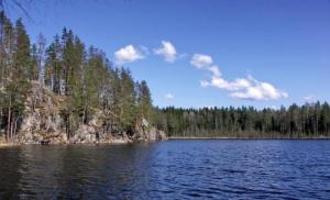
The lakes of the Kuril Islands are also famous for their beauty. The mountain lake Osen on the island of Onekotan is especially picturesque. It is round in shape, the banks are framed by steep 600-700-meter cliffs. On the island of Kunashir there is a boiling lake Ponto. The water here seethes, bubbles, and jets of gas and steam whistle out near the shores.
On the slopes of the Baransky volcano there are unique thermal springs and reservoirs, and on the rocky plateau there is an entire geothermal station that generates electricity. There are geysers, lakes, sulfur streams and pools of boiling mud. The most famous hot lake is the Emerald Eye, whose temperature reaches 90 degrees. The Boiling River flows from it with hot and sour water, which breaks off in one place and falls from an 8-meter height as a hot waterfall.
The water in the sea around the islands is crystal clear, and the bottom is covered with vegetation, where fish and other marine life live. Divers will be interested here: in addition to marine life, at the bottom you can see sunken Japanese ships and other military equipment.
National parks
There are two national parks on the territory of the Kuril Archipelago. The Small Kuriles Nature Reserve is located on several islands at once, mostly on Shikotan, and also includes part of the Pacific Ocean. The reserve was established in 1982 to preserve the population of rare birds and animals, mainly marine ones. Seals, northern fur seals, gray dolphins, humpback whales and other animals live here.
The Kuril Islands are represented by a series of Far Eastern island territories; one side is the Kamchatka Peninsula, and the other is the island. Hokkaido in . The Kuril Islands of Russia are represented by the Sakhalin region, which stretches approximately 1,200 km in length with an area of 15,600 square kilometers.


The islands of the Kuril chain are represented by two groups located opposite each other - called Big and Small. A large group located in the south includes Kunashir, Iturup and others, in the center are Simushir, Keta and in the north are the remaining island territories.
Shikotan, Habomai and a number of others are considered the Lesser Kuril Islands. For the most part, all island territories are mountainous and reach a height of 2,339 meters. The Kuril Islands on their lands have approximately 40 volcanic hills that are still active. There are also springs with hot mineral water here. The south of the Kuril Islands is covered with forests, and the north attracts with unique tundra vegetation.
The problem of the Kuril Islands lies in the unresolved dispute between the Japanese and Russian sides over who owns them. And it has remained open since the Second World War.
After the war, the Kuril Islands became part of the USSR. But Japan considers the territories of the southern Kuril Islands, and these are Iturup, Kunashir, Shikotan with the Habomai group of islands, its territory, without having a legal basis. Russia does not recognize the fact of a dispute with the Japanese side over these territories, since their ownership is legal.

The problem of the Kuril Islands is the main obstacle to a peaceful settlement of relations between Japan and Russia.
The essence of the dispute between Japan and Russia
The Japanese are demanding the Kuril Islands be returned to them. Almost the entire population there is convinced that these lands are originally Japanese. This dispute between the two states has been going on for a very long time, escalating after the Second World War.
Russia is not inclined to yield to Japanese state leaders on this issue. The peace agreement has not yet been signed, and this is connected precisely with the four disputed South Kuril Islands. About the legality of Japan's claims to the Kuril Islands in this video.
Meanings of the Southern Kuril Islands
The Southern Kuril Islands have several meanings for both countries:
- Military. The Southern Kuril Islands are of military importance due to the only access to the Pacific Ocean for the country's fleet. And all because of the scarcity of geographical formations. At the moment, ships are entering ocean waters through the Sangar Strait, because it is impossible to pass through the La Perouse Strait due to icing. Therefore, submarines are located in Kamchatka - Avachinskaya Bay. The military bases operating during the Soviet era have now all been looted and abandoned.
- Economic. Economic significance - the Sakhalin region has quite serious hydrocarbon potential. And the fact that the entire territory of the Kuril Islands belongs to Russia allows you to use the waters there at your discretion. Although its central part belongs to the Japanese side. In addition to water resources, there is such a rare metal as rhenium. By extracting it, the Russian Federation is in third place in the production of minerals and sulfur. For the Japanese, this area is important for fishing and agricultural needs. This caught fish is used by the Japanese to grow rice - they simply pour it onto the rice fields to fertilize it.
- Social. By and large, there is no special social interest for ordinary people in the southern Kuril Islands. This is because there are no modern megacities, people mostly work there and their lives are spent in cabins. Supplies are delivered by air, and less frequently by water due to constant storms. Therefore, the Kuril Islands are more of a military-industrial facility than a social one.
- Tourist. In this regard, things are better in the southern Kuril Islands. These places will be of interest to many people who are attracted by everything real, natural and extreme. It is unlikely that anyone will remain indifferent at the sight of a thermal spring gushing out of the ground, or from climbing the caldera of a volcano and crossing the fumarole field on foot. And there’s no need to talk about the views that open up to your eyes.
For this reason, the dispute over the ownership of the Kuril Islands never gets off the ground.
Dispute over Kuril territory
Who owns these four island territories - Shikotan, Iturup, Kunashir and the Habomai Islands - is not an easy question.
Information from written sources points to the discoverers of the Kuril Islands - the Dutch. The Russians were the first to populate the territory of Chishimu. Shikotan Island and the other three were designated for the first time by the Japanese. But the fact of discovery does not yet provide grounds for ownership of this territory.
The island of Shikotan is considered the end of the world because of the cape of the same name located near the village of Malokurilsky. It impresses with its 40-meter drop into the ocean waters. This place is called the edge of the world due to the stunning view of the vastness of the Pacific Ocean.
Shikotan Island translates as Big City. It stretches for 27 kilometers, measures 13 kilometers in width, and occupies an area of 225 square meters. km. The highest point of the island is the mountain of the same name, rising 412 meters. Part of its territory belongs to the state nature reserve.
Shikotan Island has a very rugged coastline with numerous bays, capes and cliffs.
Previously, it was thought that the mountains on the island were volcanoes that had ceased to erupt, with which the Kuril Islands abound. But they turned out to be rocks displaced by shifts of lithospheric plates.
A little history
Long before the Russians and Japanese, the Kuril Islands were inhabited by the Ainu. The first information from Russians and Japanese about the Kuril Islands appeared only in the 17th century. A Russian expedition was sent in the 18th century, after which about 9,000 Ainu became Russian citizens.
A treaty was signed between Russia and Japan (1855), called Shimodsky, where boundaries were established allowing Japanese citizens to trade on 2/3 of this land. Sakhalin remained no man's territory. After 20 years, Russia became the undivided owner of this land, then lost the south in the Russo-Japanese War. But during the Second World War, Soviet troops were still able to regain the south of Sakhalin and the Kuril Islands as a whole.
A peace agreement was nevertheless signed between the victorious states and Japan, and this happened in San Francisco in 1951. And according to it, Japan has absolutely no rights to the Kuril Islands.
But then the signing by the Soviet side did not happen, which was considered by many researchers to be a mistake. But there were serious reasons for this:
- The document did not specifically indicate what was included in the Kuril Islands. The Americans said that it was necessary to apply to a special international court for this. Plus, a member of the Japanese delegation announced that the southern disputed islands are not the territory of the Kuril Islands.
- The document also did not indicate exactly who would own the Kuril Islands. That is, the issue remained controversial.
In 1956, the USSR and the Japanese side signed a declaration preparing a platform for the main peace agreement. In it, the Country of the Soviets meets the Japanese halfway and agrees to transfer to them only the two disputed islands of Habomai and Shikotan. But with a condition - only after signing a peace agreement.
The declaration contains several subtleties:
- The word “transfer” means that they belong to the USSR.
- This transfer will actually take place after the signatures on the peace treaty have been signed.
- This applies only to the two Kuril Islands.
This was a positive development between the Soviet Union and the Japanese side, but it also caused concern among the Americans. Thanks to Washington pressure, the Japanese government completely changed ministerial positions and new officials who took high positions began to prepare a military agreement between America and Japan, which began to operate in 1960.
After this, a call came from Japan to give up not two islands offered to the USSR, but four. America puts pressure on the fact that all agreements between the Country of Soviets and Japan are not necessary to be fulfilled, they are supposedly declarative. And the existing and current military agreement between the Japanese and the Americans implies the deployment of their troops on Japanese territory. Accordingly, they have now come even closer to Russian territory. 
Based on all this, Russian diplomats stated that until all foreign troops are withdrawn from its territory, a peace agreement cannot even be discussed. But in any case, we are talking about only two islands in the Kuril Islands.
As a result, American security forces are still located on Japanese territory. The Japanese insist on the transfer of the 4 Kuril Islands, as stated in the declaration.
The second half of the 80s of the 20th century was marked by the weakening of the Soviet Union and in these conditions the Japanese side again raises this topic. But the dispute over who will own the South Kuril Islands remains open. The Tokyo Declaration of 1993 states that the Russian Federation is the legal successor of the Soviet Union, and accordingly, previously signed papers must be recognized by both parties. It also indicated the direction to move towards resolving the territorial affiliation of the disputed four Kuril Islands.
The advent of the 21st century, and specifically 2004, was marked by the raising of this topic again at a meeting between Russian President Putin and the Prime Minister of Japan. And again everything happened again - the Russian side offers its conditions for signing a peace agreement, and Japanese officials insist that all four South Kuril Islands be transferred to their disposal. 
2005 was marked by the Russian president's willingness to end the dispute, guided by the 1956 agreement, and transfer two island territories to Japan, but Japanese leaders did not agree with this proposal.
In order to somehow reduce tensions between the two states, the Japanese side was offered to help develop nuclear energy, develop infrastructure and tourism, and also improve the environmental situation, as well as security. The Russian side accepted this proposal.
At the moment, for Russia there is no question of who owns the Kuril Islands. Without any doubt, this is the territory of the Russian Federation, based on real facts - based on the results of the Second World War and the generally recognized UN Charter. 
The harsh reality of these places is such that it serves as a constant reminder to people that the crown of “king of nature” was awarded to them self-appointedly and completely undeservedly. Because here, in the face of nature, we sometimes find ourselves unarmed. Frequent earthquakes, tsunamis and volcanic eruptions have more than once led to people leaving their habitable places without hope of restoring entire settlements. There are many such abandoned villages, urban-type settlements and military towns here. And in this sense, Severo-Kurilsk was lucky, which, although it was completely destroyed by the wave of 1952, was then rebuilt.
Severo-Kurilsk
Severo-Kurilsk is a city in the Sakhalin region with a population of less than 2,500 people, located in the northeast of the Kuril island of Paramushir. Severo-Kurilsk is located at the foot of Mount Ebeko, just 7 km away. from an active volcano. The city's economy is based on the extraction and processing of fish (navaga, flounder and pollock) and seafood, mainly crabs and squid. There is a fishing port.
Two dams with small power plants were built on the river close to the city. The search for geothermal sources is underway. The city also has a small airport designed to serve helicopters. The picturesque surroundings of Severo-Kurilsk and the presence of mineral springs form the basis for recreation for residents and guests of the city.
Despite the fact that the city territorially belongs to the Sakhalin region, passenger traffic is provided only with the Kamchatka Territory, since the distance to Petropavlovsk-Kamchatsky is 4 times less than to Yuzhno-Sakhalinsk. From the Kamchatka Peninsula you can get here by air in less than 2 hours. The sea journey is 16-18 hours - currently sea transportation from Petropavlovsk-Kamchatsky is carried out by the passenger ship "Gipanis".
The North Kuril region includes the following islands: Shumshu, Paramushir, Atlasova, Antsiferova, Makarushi, Onekotan, Kharimkotan, Shiashkotan, Ekarma, Chirikotan, Matua, Rasshua, Ushishir, Ketoi, as well as a number of small islands such as Avos rock and Trap rocks .

Kurilsk
Kurilsk is a city in the Sakhalin region, located on the Iturup island of the Kuril ridge. The population does not exceed 2000 people. Kurilsk has a seaport, a fishery for the reproduction of pink salmon, a seismic station, a weather station, a tsunami warning station, and even has its own local history museum with a collection of archaeological and ethnographic materials.
The municipality is located in the central part of the Kuril Islands and includes the islands: Iturup, Urup, Broughtona, Black Brothers (Chirpoy, Brat-Chirpoev), Simushir and many small islands and rocks.
The Kuril urban district includes 7 villages: Kitovoe, Rybaki, Burevestnik, Gornoye, Goryachiye Klyuchi, Reidovo. These are small settlements, for example, in the village of Rybaki there are only 20 people, in Burevestnik there are not even 200, in Kitov about 600, in Reidovo about 1000. In the rest, the population has crossed the 1000th threshold, since military units are located on the territory of these settlements .

Yuzhno-Kurilsk
Yuzhno-Kurilsk is an urban-type settlement located on Kunashir Island, with a population of about 7,000 people. It was also rebuilt several times after destruction caused by natural disasters.
In Yuzhno-Kurilsk, as in other cities of the islands, there are several fishing enterprises.
OJSC Kuril Mining and Geological Company, based in the village, is engaged in geological exploration and mining of precious metals at gold mining sites in the Sakhalin region.
In addition, the Mendeleevskaya Geothermal Power Plant and heat supply station are being built in the village, which will make it possible in the future to abandon the expensive imports of coal and diesel fuel and completely transfer Yuzhno-Kurilsk to geothermal heat supply.
16 km. From the village there is the Mendeleevo airport, where you can fly from Yuzhno-Sakhalinsk in less than two hours. Sea communication between Sakhalin and Yuzhno-Kurilsk is provided by the motor ships “Marina Tsvetaeva” and “Igor Farkhutdinov”. In addition, from here you can get to Shikotan, where the Nadezhda and Druzhba ships sail. And only cargo flights go to Vladivostok.
Not far from the village there is a “Hot Beach”, where you can relax at the thermal springs and these are far from the only natural attractions of the South Kuril urban district.
In addition, here you can visit the local history museum and the Neolithic site of an ancient man, which is located on the left bank of the Alekhina River.
The Kuril Islands, part of the Sakhalin region, consist of 56 large and small islands of volcanic origin. Stretching from north to south, from Kamchatka to the Japanese island of Hokkaido, these islands are of much more geostrategic importance for Russia than might seem at first glance.
Non-freezing straits
Between the islands of the Kuril ridge there are only two straits that do not freeze in the cold season. This is the Catherine Strait, located between the islands of Iturup and Kunashir, as well as the Frieza Strait between the islands of Iturup and Urup. If these southern islands belonged to another country, it is difficult to even imagine how transport links would be carried out between, for example, Petropavlovsk-Kamchatsky and Vladivostok in winter. In addition, we should not forget about the Russian navy in the Far East. Ships from Vladivostok will not be able to sail into the Pacific Ocean in winter without agreement with third countries.
Mineral deposits

Despite their small size, the islands of the Kuril ridge contain significant amounts of explored minerals. Ores of non-ferrous metals and mercury were found here, and hydrocarbon deposits were found in the coastal zone. In addition, the richest rhenium mineral deposit in the world was found on Iturup Island. Rhenium is contained here in the form of the mineral rhenium, the extraction of the metal from which is more promising than mining by traditional methods. In addition, rhenium is a very rare metal with a number of unique properties, and therefore it is highly valued on the world market.
Status of the Sea of Okhotsk

In 2014, one of the most important recent events took place in the field of regulating the legal status of Russian shelf territories. The UN Commission on the Continental Shelf recognized the Sea of Okhotsk as an internal sea of the Russian Federation, and, accordingly, the rights to all the natural resources that this territory contains. These are not only the richest hydrocarbon deposits, but also biological resources - fish, crabs and other seafood. It is not difficult to guess that if at least part of the Kuril Islands belonged to another country, Russia would have to share these wealth with its neighbor.
Fishing for biological resources

The coastal waters of the Kuril Islands are the richest reserves of Kamchatka crabs, salmon and many other valuable biological resources. The increased interest in this territory on the part of other countries is eloquently evidenced by regular cases of poaching of foreign ships in the coastal waters of the archipelago.
Population of the Kuril Islands

Ice-free straits and natural resources are, of course, very important. But the main wealth of the Kuril Islands is the people who live here. According to 2017 data, more than 19 thousand people live on the territory of two cities and several villages. This is quite a lot, given the island specificity of the region and certain difficulties caused by transport accessibility. The islands are a special world, and the people who inhabit the Kuril Islands love their small homeland very much.