Rybachy Peninsula: a journey to the edge of the Earth. Land's end - fishing peninsula Fishing peninsula and middle history
Why do we love the north so much? Because the beauty of these places can not only be seen, but lived! Test yourself, your courage, your endurance and stamina. Overcoming the challenges of the chosen path is much more expensive than the gentle southern seas and beaches. Returning from the north, the trace of power does not fade in your gaze.
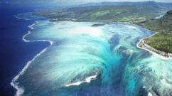
The Rybachy Peninsula is located in the north-west of the Murmansk region, it is a real “end of the earth”. The plateau drops steeply to the Arctic Ocean with sheer black cliffs. Off the coast of Rybachy, the waters do not freeze all year round thanks to the warm North Cape Current. That is why at different times it was a haven for the Vikings, the land of the Sami, and even a closed military base. Today the Rybachy Peninsula is famous for the largest bird colonies in the northern part of Europe.
The raging Barents Sea, chilly rain and roaring wind - these are the Rybachy Lands - extreme point The European part of Russia, further only the Arctic Ocean and the North Pole. There are no trees and countless stones in this world. The weather here changes ten times a day, and the sun never sets below the horizon....
Our route will go along natural park"Fishing". We will see the splendor of the blooming tundra, picturesque bays and bays, sandy beaches, waterfalls. We will hear the hubbub of bird colonies. Perhaps we will come across herds of deer on our way.
Here in the sea there are crabs, and the streams are rich in salmon. Travelers come to the peninsula for various reasons. Some people want to admire northern nature.
Someone wants to see with their own eyes the sites of ancient settlements and visit modern reindeer herding sites. Many are also interested in monuments related to Rybachy’s military past and its former military camps. Traces of war can be found everywhere here. Among the stones there are rusty fragments of mines and shells, the remains of Soviet and German barbed wire, grenade casings, broken weapons and shell casings. The defense of Sredny and Rybachye continued for 1,200 days and nights.
Number of participants: from 6 to 10 people.
Age limit: from 14 years old, accompanied by parents.
Features of the trip: backpacks are full from the first day - there will be no drops of food, inaccessibility at the exit from the route is not planned.
Activities
Route threads
Murmansk - Sredny Peninsula - Volokovaya Bay
The goal of this day is to reach Cape Koroviy.
Pos. Vaida Bay - Cape "German"
Let's go to Cape Skarbeevsky
The center of the peninsula is Mount Perevalnaya
Mountain stream Lonsky
Musta Tunturi Ridge
Departure to the city of Murmansk
Route by day
Using ordered SUVs, the group travels to the village of Novaya Titovka, where they examine the waterfall on the Titovka River and have lunch. Then through the Musta Tunturi ridge and the Sredny peninsula we go to the beginning walking route. Upon arrival at the starting point of the route - Volokovaya Bay, we distribute public equipment and food into backpacks and go to the first overnight stop about 10 km along coastline.
The goal of this day is to reach Cape Koroviy. We will see fortifications left over from the Great Patriotic War. Trenches carved into rocks, underground structures, firing points. We will go up to the tundra lakes and see bird colonies on the rocks. The length of the second day is about 15 km.
We leave the coastline towards the village of Vaida - Guba, our path lies to Cape German. On the way we will pass by several German bunkers (long-term firing points), several meters high, made of natural stone. These structures are well preserved, they are not destroyed and can be viewed both outside and inside. Then we will pass by the military town and go out to Cape Nemetsky.
T We will see the northernmost lighthouse of the continental European part of Russia, an abandoned border post and admire the ocean surf. We pass by the operating weather station to the bay where we set up camp.
At the beginning of the sailing day, we will pass by the graves of British pilots who died defending Allied caravans. Next we cross the river and move along the road to Cape Kekursky. Here you can feel Eternity and only here can anyone feel the full power of nature.
Tundra vegetation, a unique landscape, green and white lichens, moss, reindeer moss create unique landscapes in combination with rocks and the sea.
We go to Cape Skarbeevsky. Once again we see reminders of the battles of the Great Patriotic War, we go out to the sea several times, where we admire the bird colonies on the steep cliffs.
The abandoned military town through which our path lies resembles the set of a Hollywood horror film. Our stop on this day is picturesque place under the rocks on the seashore. 16 km covered.
The route goes to the center of the Rybachy Peninsula to Mount Perevalnaya. The sea will quickly disappear from view and the endless expanses of the polar tundra will stretch out before us. Mosses, lichens, stones, mysterious seids and abandoned checkpoints will accompany us all day.
The herds of deer grazing here are evidenced by the antlers you come across along the way. Parking on the shore of a pristine tundra lake.
We descend from Mount Perevalnaya along a picturesque canyon carved into the rocks by the stormy mountain stream Lonsky. We reach the isthmus between the Rybachy and Sredny peninsulas. We will stop at a designated parking lot next to the obelisk dedicated to the authors of the song “Farewell Rocky Mountains...” 14 km covered
Along the shore of Bolshaya Motka Bay we go towards the Musta Tunturi ridge. On this day we will visit a museum dedicated to the defense of the peninsula from German invaders. Parking in the foothills of Musta Tunturi. Walked about 20 km. Saying goodbye to rocky mountains, as sung in a Soviet song by Evgeny Zharkovsky (music) and Evgeny Bukin (text). The poems set to music were written by the poet on the Rybachy Peninsula - the only place where the Nazis failed to cross the border of the Soviet Union.
Goodbye rocky mountains
The Fatherland is calling for heroic deeds!
We set out on the open sea,
On a harsh and long journey.
And the waves moan and cry,
And they splash on board the ship...
Rybachy melted into the distant fog,
Our native land.
My ship stubbornly rocks
Cool sea wave
Picks it up and throws it again
She's into the boiling abyss.
I won't be back soon,
But enough fire for the battle.
I know, friends, that I cannot live without the sea,
Like the sea is dead without me.
Departure to the city of Murmansk. Tickets can be purchased after 20.00
It consists of two parts, the Rybachy Peninsula itself and the Middle Peninsula. They are connected by an isthmus, the length of which reaches approximately 1 km. These peninsulas are connected to the mainland by another isthmus, which is about 2 km long. The length of the Rybachy Peninsula from Cape Gordeev to Cape Nemetsky is about 60 km, the width at the northwestern end reaches 10 km, and at the southeastern end up to 25 km.
The shores of the peninsula consist of black slate rocks, above which, inside the peninsula, there are low hills and mountains, covered and partly with grass. Along the banks of rivers and in the valleys between the hills there are partly dry areas with good grass. There are also small forests of birch, willow and other shrubs.
There are many lakes in the northern part of the peninsula. Of the latter, the most significant is Bezymyanny Lake, whose length reaches up to 10 kilometers and width up to 1 kilometer. The Mainavolok River, whose length is up to 10 km, flows out of it. Other rivers on the Rybachy Peninsula include the Zubova River (length about 13 km), Olenka (about 12 km), the source of Lake Olenka and other water bodies.
The peninsula has large number various bays and bays. Although few of them can serve as reliable shelters for ships. Starting from the southwest there are bays: Malaya Volokovaya, Bolshaya Volokovaya, on the northwestern coast - Vaida Bay. On the northeastern part of the peninsula there are bays: Skarbeeva, Zubova, Mainavolotskaya, on the eastern shore of the bay: Tsyp-Navolok, Korabelnaya, Anikieva and Sergeeva.
On south coast On the Rybachy Peninsula there is the vast Mitavsky Bay with the bays of Eina, Mocha, Motka and the harbor of Novozemelskaya; on the southwestern coast there is Kutovaya Bay. The most famous of the capes are: Cape Gordeev, located on the southeastern tip of the peninsula, capes Sharapov, Bashenka and Sergeev, located on the eastern shore. In the northeastern part of the peninsula there are capes Tsyp-Navolok and Lavysh, Lok, Lazar, Mainavolok, Skorbeev; in the northwestern region - capes Kekur and Nemetsky; on the western part of the peninsula there is Zemlyanoy Cape and some others.
The highest points of the peninsula are located on the capes: Gordeev, Kekur and Gremyashchinskaya pakhta (its height reaches about 1450 m above sea level). Other capes have heights from 900 to 1800 m. The northeastern coast of the peninsula is low. The northwestern coast is elevated and in some places reaches 6000 m. Beyond the Bolshaya Volokovaya Bay, the banks again become sloping. The middle peninsula approaches the fiord with tundra shallows.
The fishing peninsula was formerly inhabited by Lapps (a population of the Finnish tribe). Since 1865, colonies of free migrants began to be established here, mainly Finnish and west bank Varangerfjord and Norwegian Finnmarken. These peoples became Russian subjects, but economically they gravitated towards their former homeland. The Fisherman's and Middle Peninsulas constituted the Fisherman's Rural Society. Almost all Lapps migrated from the peninsula to the mainland. Russians (up to 600 people) came here only in the summer, for fishing, in some fishing camps, for example: Vaida-guba, Zubovo and Tsyp-Navolok.
Both the Norwegian and Finnish colonies then settled down well. Many of them prospered thanks to fishing, cattle breeding, trade and other industries. In total, there were about 9 colonies on the Rybachy Peninsula. They had about 500 inhabitants. On the Rybachy Peninsula in the Vaida Guba colony, considered one of the main places in Murmansk for the abundance of cod fishing, from 400 to 500 thousand kg were caught per year. The colonists had up to 100 fishing vessels, on which they caught up to 1,130 thousand kg of marine fish and up to 80 thousand kg of fish oil. On the same ships they carried out trade with the Norwegian towns of Varangerfjord.
In the second half of the 19th century, the famous thinker Nikolai Fedorovich (he was Tsiolkovsky’s teacher) proposed establishing the capitals of Russia on the territory of the Rybachy Peninsula. After the revolution at the beginning of the 20th century, the territories of the western zone of the Rybachy Peninsula and the Middle Peninsula began to belong. In 1940, after the Soviet-Finnish war, these territories were again returned to our country.
On the territory of the Rybachy Peninsula there are deposits of hydrocarbons, oil and. In the 70s of the last century, searches were carried out here, but as a result of insufficient research, these searches were unsuccessful. In 1994, seismic surveys were made on the peninsula, which revealed oil deposits. Oil deposits are located from the peninsula into the sea. The expanses of Rybachy and Sredny are used for reindeer grazing.
A special feature of the waters washed by the shores of the Rybachy Peninsula is that they do not freeze even in winter. The rise in water here is influenced by the North Cape. Currently, based on the results of the expedition of scientists to the territory of the Rybachy Peninsula, a decision has been made to create protected areas here to preserve the fauna of these places.
To see Rybachy and not die... from delight, well, at least try. These words very accurately reflect the emotions of visiting the northernmost European part of Russia. It feels like when moving around the peninsula, you are passing through several countries: there are mountains, the sea, waterfalls, lakes, and even different seasons.
As one member of the “Discovering the Silver Necklace” expedition said: “This is the coolest thing I’ve seen in my life!”
Until recently, the peninsula was a closed area, so you can only get here by car.

The Rybachy Peninsula is located on the Lapland coast of the Arctic Ocean. Between the mainland and the Rybachy Peninsula is the Sredny Peninsula. Many consider these peninsulas to be a single peninsula and call them by one name - Rybachy. In this entire vast territory there are only four bases where a traveler can stop.

We got to know Rybachy with the help of the mega hospitable guys from the base "Cool North". We were late for a trip around the peninsula on ATVs - the weather was no longer permitting, so we explored the territory in a GAZ-66, popularly known as a shishiga.

Here she is a fire-machine - Shishiga, which passes such roads, mountains and fords that one can only be amazed.

After the Second World War, the peninsula was inhabited mainly by military personnel and geologists. In the 90s, Rybachy was practically deserted, so the roads and bridges in many places are in such a state that overcoming them becomes a quest. But Shishiga coped with everything and the expedition members are now safely at home on the mainland.

During two days of traveling around the peninsula, we saw 2 people and one car.

Barents Sea. The North Pole is located 2200 km from here.

Despite its northern position, the Rybachy Peninsula is the most warm place Murmansk region and the entire Russian north. Off the coast of the peninsula, the sea does not freeze all year round.

White wave lambs Barents Sea They don’t let go, I don’t want to leave. The sea, although cold, is so attractive in the sun’s rays. But our guide urges us on: “You haven’t seen so much yet!!!”

After the flat waterfalls of Karelia and the mainland Murmansk region, Rybachy waterfalls amaze with their height and power.

One coast, and the weather changes at cosmic speed.

At the entrance to Cape Kekursky, the clouds scattered and the sun came out.

On the cape there are probably the most picturesque cliffs of the peninsula. Bagpipes immediately began to sound in my ears, and the tartan pattern flashed in my eyes, like in the TV series “Highlander”, which I watched so much in my adolescence :)

Near Cape Kekursky there is Guba-Vayda, as guides and books say, there was a trading market “Kegor”, where the British, Danes, and Dutch sailed to sell their goods. From here these goods were already on their way to Arkhangelsk and Moscow.

Mount Motka greeted us with snow and fog, because of which we could not see anything. Although we were told that the views here are more beautiful than from Cape Kekursky.

During the war, a divisional command post was located on this mountain. In general, we were warned that we definitely need to watch our step, because on Rybachy you can still find “echoes of war.”

Bloggers are bloggers. There are no views, but there is Internet from Megafon. I had to stay here and disrupt the peninsular internet detox program.


If you like abandoned buildings, then you will find something to see here. The Bolshoye Ozerko garrison was disbanded in 1987, and by the 90s everyone had left the village.

The village had a hospital, a school, a canteen, a diesel station and even a museum.

In the 60s and 70s, the first five-story building on the peninsulas with all public amenities appeared.


When you walk around someone else’s apartment, you see that in every kitchen there is a stove, you realize what incredible work it took to build all this on the peninsula and how difficult it was for people to organize their lives.

It is a pity that all efforts went to waste and no one else needs it.

We're going to the next waterfall.

Photos do not convey all the beauty and power of Rybachy’s nature. You look at the camera screen and everything seems flat and small. You want to ask for a camera and just soak in everything you see around you.

Do you want to see mushrooms that are taller than trees? Here they are - boletuses.

And there’s no way to stop the desire to tell the world about what you saw, right away. The same Megafon periodically gave us such an opportunity.

He's probably listening to something on Storytel about the origins of the Northern Sea Route :)


Along the roads there are barrels filled with stones with a stick sticking out - poles. We were told that this was also left over from the military.

Cape German, next to it is the village of Vaida-Guba, where there is a weather station and a lighthouse. As the northernmost point of the European part of Russia, the cape attracts thousands of tourists.

Unfortunately, there was quite a lot of plastic on the shore (Greta, you were right) and the remains of a whale that washed up 3 years ago. There are also many cairns here. It is believed that when building a pyramid they make a wish, and the stronger and larger the structure, the more likely it is that dreams will come true.

Well, here we are at the End of the Earth!
In mid-July, due to business needs, my colleagues and I found ourselves on a two-week business trip to Murmansk. Since we arrived in Murmansk in my car, we tried to spend our free time from work actively: we saw the city, fished in the Kola Bay several times, went to Teriberka twice, and I also managed to visit the Rybachy Peninsula...
One weekend, I was lying on the sofa of a rented apartment and decided to read information about the Rybachy Peninsula and reviews of car travelers on my smartphone. The more I read, the more excited I became about the idea of going there. Considering the bad roads and lack of preparation for the trip, I planned to only get to the Musta-Tunturi pass, walk there along the rocks, through the battle sites and return back. It took no more than half an hour to get ready; in fact, there was no getting ready, I just drank coffee, smoked a cigarette and went. I planned to refuel along the way, stop at a store for some food and water, but somehow I missed all the stores and, having refueled, drove off with a bottle with about 50 ml of water in the back seat. This attitude towards provisions was a big mistake, I realized it quickly. During the entire two weeks of our business trip, the temperature was about 30C, which, coupled with high humidity, created a terrible stuffiness. The day of the trip was no exception and I already wanted to drink about 50 kilometers from Murmansk.
The route from Murmansk to the Titovka checkpoint is excellent, everyone’s documents at the checkpoint are checked. As I understand it, the main requirement for free travel is citizenship Russian Federation. After the checkpoint, turn right onto the dirt road; in fact, from this moment the adventure begins. The road along the Titovka River is full of potholes and potholes, like the rest of the route. There’s probably no point in describing the quality of the “coverage,” because there is none, there are plenty of reviews on the Internet, I’ll just say that it’s quite possible to drive if you’re careful.

The road along the river is replete with picturesque views and I stopped several times to admire and take photos. Unfortunately, the photo does not convey the height.

After some time the road goes away to the left of the river and, twisting, rises higher and higher to the pass. Not the Caucasus, of course, but the rocky northern hills have their own special beauty, and it’s not for nothing that people who have visited these places once come here again and again.

While driving along Titovka, I was very thirsty, it felt like my palate was stuck together and cracked, I definitely decided that I would reach the pass and turn back. At some point, while driving around another pothole, it seemed to me that there was a bottle lying in the road dust, I drove by, looked in the mirror - it really looked like a bottle. I stopped, walked up and was stunned; in the road dust lay a one and a half liter sealed bottle of “Holy Spring” water. At that moment it was a sign for me, a sign that I had to go further, beyond the pass. And indeed, as soon as I got drunk, my mood immediately lifted and I had the strength and desire to move on. After that I quickly reached the Musta-Tunturi pass.

Unfortunately, I was not prepared for this trip and did not have a plan or any points of interest, so, stopping at the pass, I simply walked along the surrounding rocks. I climbed the peaks in search of traces of the war. Found it.

 Echoes of War
 Beyond the pass the road began to descend, also replete with views worthy of an artist’s brush. I stopped and admired it several times. Thus I reached the Sredny Peninsula. I didn’t like the path through the Sredniy peninsula: a dead road, pits tossing the car from side to side, speed of 10 km/h, monotonous landscape on the left and Bolshaya Motka Bay on the right. From time to time, on the coast of the bay there were camps for visiting fishermen and tourists. Sights of the Middle - monuments to Soviet soldiers who fell in battle. In my opinion, you need to go to Sredniy specifically to touch the history of the Great Patriotic War, not just passing through like me, but thoughtfully, knowing specific points. It was in these places and about the events that took place in these places that Konstantin Simonov wrote the poem “Son of an Artilleryman.”
 Reminded me of “Son of an Artilleryman” by K. Simonov


 The Middle Peninsula is a war
 On the middle I traveled along the eastern shore and ended up on the isthmus with Rybachy. I set myself the task of getting to Cape Nemetsky, the northernmost point of the peninsula, which is also the northernmost point of the European part of continental Russia. I read in one of the reviews that it’s better to get there by west coast Rybachy, that’s what I did. Having passed the isthmus, I immediately turned left onto the road leading to Cape Nemetsky, leaving the abandoned village of Bolshoye Ozerko on the right. The Rybachy Peninsula is no longer as monotonous as the Middle Peninsula, at least it seemed so to me. I drove towards the sun, sometimes it made it very difficult to drive around stones and holes, but the views were simply fantastic.


The road on the western side of Rybachy is better than on the eastern side of Sredny, the speed is also 10-15 km/h, but somehow it’s more varied. The car wobbles less from side to side, but there are a lot of large stones and fords. If you're not in a hurry, you can easily drive almost any car.

Perhaps the strongest impression on me was the beach, about one kilometer before Chervyanyi Ruchey. Dark gray sand, as transparent as an angel's tear, sea water in the rays of the setting sun, calm and warm evening... I didn’t swim right away, I decided to cheer up on way back, but, looking ahead, I will say that it was not possible, because by that time the low tide had pushed the water back by 150 meters and the view of the beach was no longer so fabulous. Photos can't do it justice, you have to see it in person, it's worth it!

From this place it is just a stone's throw to Cape German. Having wandered a little along the roads of the tundra in unsuccessful attempts to bypass a military unit standing in the way, I reached my destination.

Below is a short video sketch that I made from videos shot on a mobile phone. I was filming with one hand and holding the steering wheel with the other, so the areas that had to be overcome while holding the steering wheel with both hands were left behind the scenes.
I stayed at the end point for no more than an hour, walked around, admired the sea and went back. The return journey followed the same route. I left home at about 2:30 pm and returned back around 9:30 am.
While driving along Rybachy, I met a car of French travelers. I didn’t notice any people nearby, so I just drove past. Having already returned to St. Petersburg, I went to the website indicated on board their car and read information about them, about the car and their travels. Read it, it’s interesting to look at our country through the eyes of foreigners who have seen it not only in football stadiums and bars in big cities.

P.S. I consider it my duty to ask you, friends, please don’t litter. The tundra will not take anything; everything you left will lie there for decades, if not centuries. The soil layer is very small, do not tear it with tire treads, it will take a very long time to heal, there are roads there.
P.P.S. Just a week ago I was sure that I would no longer travel by car to Rybachy, but now I’m already thinking about proper preparation and how to plan the route. I will go, I will definitely go again, but not in a hurry, with fishing and spending the night in a tent...
In the evening we were already in place.
The Rybachy and Sredny peninsulas have been a military specially protected area for decades. Back then, probably no one even dreamed of traveling along them. They knew that there, in the northernmost mainland of Russia, off the coast of the Arctic Ocean, there were peninsulas on which there were military personnel, missile troops and border guards who guarded against European enemies.
The first desire that immediately arose when setting up a tent was to save these flowers and grass. Do not trample them with your feet, much less with wheels.
They already had to be born in these harsh climatic conditions.
3.

4.
In the 90s, Gorbachev made concessions to the civilized worlds and withdrew the military from the peninsula. Since then, Russians have gained another huge territory for travel, recreation and fishing.
5.
The military left, but did not transfer the territory in status. The Rybachy and Sredny peninsulas are suspended in the air without a definite status of belonging. Military settlements were abandoned. Looters stole valuables, and time and north winds picked up this baton.
Everywhere you look, there are remnants of military equipment, garbage from the military and from new travelers. These objects only reek of sadness and disappointment. I didn't want to take pictures.
6.
All along the shores of Rybachy Bay, a wave washed up logs from some kind of structure.
7.

When we stopped in Murmansk at a store to buy gear for sea fishing and picked up groceries along the way, I noticed that the city had not yet had time to repair the city after the German bombings.
The road from Murmansk to the turnoff to the peninsulas took a couple of hours.
From the asphalt road leading to Norway after the checkpoint, after a few hundred meters, we turned right and immediately found ourselves in the USSR in 1943.
Although I was warned, I was still shocked by such hellish roads. It turns out that “German bombers targeted the roads.”
We covered 100 km to our destination in 10 hours. Although our car is a real SUV, we still hit the bottom hundreds of times.
Despite the fact that such hellish roads were not only on our way, but in all directions. Like in that fairy tale: if you go there, you’ll break the wheels, here you'll drive a car leave it.
9.
10.
Only real extreme sports enthusiasts travel along these so-called roads, where there is danger on every meter.
11.

We crossed rivers, small surviving bridges, fords, puddles and mud alternated. Therefore, the peninsulas are held in high esteem among travelers, jeepers, fishermen, quads, and snowmobilers.
12.
Here and there there are broken cars on the road...
13.
Nature, despite its, at first glance, scarcity, did not allow us to take our eyes off itself. It’s a pity that we weren’t able to take much photographs; we stopped a couple of times. There was no time for that.
14.
In a couple of places on our way we encountered some stencils that did not deserve respect, as if this territory natural park. This means that somewhere there are offices and employees who receive salaries.
15.

What are they doing, maybe they built a gazebo, but that’s unlikely.
16.
At the next monument.
17.
Thousands of soldiers died on the peninsulas. Many monuments. Some of them are in good condition.
18.
Abandoned monuments abound in peninsulas like this one.
Upon closer inspection, you can see a dozen gravestones overgrown with grass.
But in the cities we pompously celebrate Victory Day and organize an immortal regiment.
19.
In fact, it is not surprising that the monuments are abandoned. If monuments near the hero’s city of Murmansk are being destroyed and there is no one to repair them, then it would not be worth expecting a better attitude towards them in the distance.
20.
21.
There is no one to get permission to fish from. So, catch as much fish, crabs, and shrimp as you can, even in tons.
Perhaps we were in the status of a poacher since we fished without a license.
22.
There was a sea of fish in the sea..))
Various fish in the depths seemed to be waiting for the lure to immediately be attacked and to be hooked.
There were also unfamiliar ones, like this scary-looking fish.
Just in case, we let her go back to sea. Then we found out that you were selling something rare.
23.

We came across these weirdos from the depths of the sea
24.
The fish were caught so well that from the very first day the question arose: “Where should I put it?”
The most cunning fishermen from the team hurriedly went out to sea on the very first day and fished with all their hearts as many as two boxes of different fish. So on the second and third day, fishing was taboo. Don't throw it away?
Then they caught as much as they could eat. And they caught fish selectively that they didn’t eat yesterday.
25.
Fried flounder fish, oh so delicious!
26.
We cooked food on gas. By the way, there are no trees as such on Rybachy. Some small handicrafts, from which there is no way to make a full-fledged fire.
Semeshkin Anatoly Konstantinovich at the workplace.
27.
28.
29.
Keith liked our presence on the shore and every day he approached us a hundred meters and defiantly blew the boiling water away from him through the pipes. Apparently its hull had holes and water was leaking out.
30.

We wanted to catch a whale for dinner. We conferred and consulted and decided not to.
31.
Shish kebab from some large fish and Armenian vodka went well together.
32.
A group of fishermen from Arkhangelsk, with two cars and trailers, specialized in crabs. They had conditions for storing fish. Therefore, they boldly caught both fish and crabs.
Moreover, they knew where and how to place nets and traps.
I even helped them for a minute to release the crab from the net. But he ate as much as he could. Before that, I only knew the taste of crab from those sticks that are sold in stores. Incredibly delicious.
It turns out that there are too many crabs in these parts. They were once brought from Kamchatka to breed, and there were so many of them that either through the bay or across the isthmus they crossed into the waters of Norway.
The paradox is that Norwegians commercially catch crabs and sell them wholesale, including to Russia.
And in Russia, mafioso responsible officials do not even allow amateur fishing. Although unofficially, but quite legally, crabs are sold in Murmansk on every corner, wholesale and retail, and in any form.
Our team did not know how and did not catch crabs. But we ate when the Arkhangelsk men treated us, and they always treated us.
33.
The crab that I lowered to the ground turned out to be warlike and attacked me and wanted to eat me. But I managed to get out...
34.
It turns out that to keep crabs longer, you need to boil them in sea water.
35.
When, on the way back at the airport, I saw what crabs were being sold for and counted how many rubles I ate for those 10 days, I felt sick. You could buy a used foreign car for that money.
36.
Although the Arkhangelsk people showed us a way to fish for crabs, for us Urals it was not a feasible dream. Bring such things with you, etc..
By the way, sometimes, but very rarely and only when they come to Rybachy good people, then it becomes warm on the peninsula, so much so that you can sunbathe and dive into the sea. That's what we did.
37.
38.
It was so hot that we only cooled down with watermelons. Like this watermelon eater.
39.
We swam in the northernmost mainland of Russia near the shore of the Arctic Ocean. Since there were no women within a radius of one hundred kilometers, they swam without swimsuits.
40.
The sea water was very clear! All the fish in it off the coast were visible despite the fact that fish and crabs relieve themselves here, not counting the whale.
41.
On Rybachy the weather is extremely changeable. Either, as it should be in the northern part of Russia, it is windy, cold, rain and snow, then it is sunny with heavy winds and rain.
This is what we experienced ourselves. A strong wind instantly tore down the fishermen's tent, although I don't remember where they came to the peninsula from to drink vodka.
42.
It turned out that the sea here ebbs and flows back every day at the same time, no matter what the weather is like outside.
A wave from the sea instantly flooded the rubber boats. Then a lot of people couldn’t drag them to the shore.
43.
In the photo is the caretaker of the Izhevsk group. The cruelest man. He always looked into the distance and commanded: “Bring a ton of fish here, take a ton of crabs there!..”
44.
For the slightest disobedience, he almost tore my friend to pieces.
Just kidding, staged shots. The kindest man
45.
Some Izhevsk guys collected cloudberries and made jam in the camp. What can you say, well done, they were thoughtful enough to bring sugar and utensils with them.
And the cloudberries were very tasty and sweet with sourness.
46.
47.
I’m amazed how all this junk in the photo fit in one car, as well as four healthy men and another nasty dog. Otherwise, it is expensive for everyone to travel such a distance in their own car. And ruin your car on these roads.
48.
The only houses on the peninsula built over the last 20 years for tourists. The toilet is outside. Wash in the sea.. Conditions are a little better than in a tent.
49.
But in your tent, although it’s a constant mess all the time, it’s cozy and warm...
Because it’s yours!!!
50.
During the war with the Germans, the peninsulas were important for defense for the USSR. Then the defenses of Rybachy and Sredny were built in such a way as to repel attacks from the sea. From the shores, our troops controlled the movements of the German fleet in the Barents Sea and did not allow them to approach Murmansk.
And now various kinds of structures were visible on every meter, if you looked closely.
Unexploded anti-submarine ships bombed on the shores of the Barents Sea.
51.
Classic technical solution.
52.

It is not clear the purpose of this nail, 4-5 cm thick, driven into the stone. Probably from the time of the Vikings.
53.
54.
It is for this reason that the peninsulas truly became a historical museum area.
On the road to Zubovka, in the most continental northern region of Russia, on the side of the roads our “guide” showed rock paintings from the Stone Age.
It is not clear who painted in these harsh lands in those centuries, Finns, Russians or Norwegians.
55.

The peninsulas were previously inhabited by Vikings (Norwegians), and they left their cultural mark in the form of ruins of trading posts and mounds of graves.
56.
Our military left a fresh and boldly uncultured trace in the form of destroyed structures.
The Norwegians, even further north than the peninsulas, have created paradise living conditions. We became one of the lucky ones in the world.
In the meantime, there are only frightening ruins around on the peninsulas.
57.

But off the coast there are submarines here and there...
59.
I left Rybachy with complete disappointment, but with the intention of returning here again someday.
I would like to return, but not in a jeep with a trailer. Stay in a cozy hotel, catch fish without fear of being a poacher, eat crabs, travel around the peninsula, go to your room in the evening, look out the window at the cold winds, wrap yourself in a blanket and sleep until dawn.
60.
Should the Vikings or Finns rent out the peninsulas? Should we, in exchange for offset, come for a couple of weeks for a free rest as a human being?
There will probably be some inaccuracies in the story, so please correct me.
It is important that if you liked the post, support me with a like and comment.