Tidal schedule on the map. Tides and tides in Zanzibar
The White Sea was influenced by the ebb and flow of the tides. The water level fluctuates regularly twice a day, and since the sea tides are controlled by the Moon, this is a lunar day, which is slightly longer than the solar day, and lasts 24 hours 48 minutes. The cycle of tidal fluctuations in water level is not 12 hours, but 12 hours 20 minutes. Each day the tide is slightly delayed, which is why it may occur at different times of the day.
In the Kandalaksha Bay, and with it in the vicinity of the White Sea Biological Station of Moscow State University, the height of the tides reaches 2.5 m, the speed of the current, which at high tide carries water to the edge of the Rugozero Bay, and at receding water turns towards the White Sea Basin - up to 0.5 m /c. The range of level fluctuations depends on the lunar phase. When the Earth, Moon and Sun are on the same line, the gravitational forces of the Sun and Moon act in the same direction and add up, during such periods at high tide the water rises higher than usual, and at low tide it recedes further. Such tides are called spring tides, they are observed during the new moon and full moon. If the Moon and the Sun are located at right angles to the Earth, then their gravitational forces partially cancel each other, and the vibrations of water are weaker. Such tides are called quadrature; they occur when the Moon is in the first quarter and last quarter phases of its cycle.
It is very important for marine researchers to know the tide time and water height in advance. Those whose work is related to the study of the littoral zone time their observations at low tide. Navigators plan loading and unloading operations when the water is full, divers plot underwater routes taking into account the direction and strength of tidal currents. For most of the inhabitants of the biological station, the table of ebbs and flows is the main document necessary for planning their working day.
Thanks to the data from the weather station installed at the pier of the biological station, and the efforts of students of the Department of Oceanology, Faculty of Geography, Moscow State University, a new reference point appeared in the program developed by the MultiEdit campaign - the White Sea Biological Station of Moscow State University. If before we had to focus on the port of Kem - the nearest settlement point in the White Sea, introduce corrections, and the accuracy was small, now we have a tide schedule directly for the BBS.
Using this program, you can see the tidal wave graph, determine the state of the water at the current moment (according to the summer time, which now, as they promise, will not change), get the tide schedule in the form of a table and print it out, find out about the phase of the lunar cycle, about the height tidal fluctuations, daylight hours. When you start the program, the current data is automatically displayed, but by moving the “slider” to the left or right, you can get the same data from the past and future, without restrictions, at intervals of days, months, or years. For example, if you have a sample taken decades ago and know the time of collection, you can easily determine at what phase of the tidal cycle it was taken, and whether it was light or dark at the time of day.
To run the program, you need to copy the archive to your computer, unpack it and run the file with the “exe” extension. A graph of the tidal wave near the MSU BBS with a mark for the current moment will immediately appear on the screen. There is a "Calendar" option in the menu to get tide tables for any time range. Using the “Help” button you will understand other features of the program.
We warn you that nature does not always follow calculated canons. Surge or surge winds can also lead to some deviations from the schedule in any direction. What can you do, such is the sea!
The program can be downloaded here:
As we have already noticed, ebbs and flows in Bali are a regular thing and you need to be prepared for them, ebbs and flows exist in all seas, sometimes they are less noticeable or almost invisible, as in the Black, Baltic, Marmara or Red Seas, but in for the rest, the values of the minimum and maximum levels differ by meters.
Exact tide schedules exist for each port. In Bali, this is primarily the port of Benoa. But it is important for you and me to know when swimming is possible and when it is problematic. Also, the values of the minimum and maximum levels are not very important to us. On some days the minimum level is the same, on other days it is different and vice versa. As you understand, they depend on the location of the Earth in its orbit and the distance of the Moon. The maximum fluctuations in water level during high and low tides in Bali are about 2-2.5 meters. It is comfortable to swim at a water level of 1 meter and above.
The greatest deviations in sea level are observed during the new moon and full moon. And the smallest level changes occur on days in the middle of them.
For our tourists, we suggest that you carefully study the tide schedules, if this is very important for you, and correctly shape your stay on the island, combining with and trips. For example, on days when the maximum low tide falls on the most productive time, we offer excursions around the island, trips to Lovina, Java, Komodo, boat trip or fishing. If you find it difficult to make a plan yourself, leave it to us.
Tide graphs are very simple, you just need to combine the date line and the time line and at the intersection there will be a sea level value in meters for a given hour of the desired day. The schedules are not round the clock, but are scheduled only for the daytime part of the day.
March 2019

If you know when and at what time the tides in Zanzibar will be and their strength, you can decide in advance a number of extremely important issues that will help organize and plan your ideal vacation.
Let's start with the fact that Zanzibar has very strong tides. On some beaches the water goes up to two kilometers and this is without exaggeration. Therefore, if you have not yet chosen a hotel and a beach where you will relax, read this article very carefully.
And if you have already chosen, do not be discouraged, because even on a beach with a high tide it is possible luxurious holiday, you just need to be able to adapt to nature.
Tides and tides in Zanzibar: map
- The black line is the line of maximum low tide. The entire eastern coast of the island is subject to strong tides. During low tides, a lot of algae and sea urchins remain. But on east coast there are still beaches where clean sand remains after low tide, beautiful scenery and there is the opportunity to take walks to the low tide line.
- This is the deserted and romantic Matemwe beach, the party beach for kiters at Paje and the moderately calm and moderately active Jambiani beach with beautiful water and cool scenery at low tide.
- The red zone is the worst beaches on the island in terms of tides. Dirty, rocky with lots of sea urchins. These two beaches are located in a bay, which at low tide turns into a post-apocalyptic landscape. This is Uroa and Chwaka beach. If you are traveling around the island and have the opportunity to visit these beaches for a couple of hours, you should do this, at least to broaden your horizons, but I do not recommend staying here for at least a day.
- The green zone is the two most northern beaches Zanzibar. There are almost no low tides here. And throughout the day you can swim in the warm Indian ocean and enjoy amazing views. Kendwa Beach and Nungwi Beach. But keep in mind that only western part Nungwi beach without low tides. The eastern part, from the lighthouse at the northernmost point of the island to the Hilton Hotel (Double Tree Resort) has daily low tides of 300-500 meters.
Conclusion for those who have not yet chosen a beach: look for hotels on the beaches of Kedwa, Nungwi, Jambiani. And if you already have everything organized and you just now learned about high tides on your beach, don’t despair. Everything is written in detail in a separate article, which also talks about the ebb and flow of the tides.
 and this is low tide on the neighboring beach with Chvaka - Jambiani. Although the water goes far away, there is clean white sand and you can take walks
 Low tides and tides in Zanzibar, Before and After:
I took two photographs from the same angle to clearly show the strength of the tides.
 Low tide in Zanzibar, fishing village not far from Matemwe beach
  High tide in Zanzibar, photo taken 4 hours later from the same place
 There is a wonderful resource on the Internet: Citypedia. On this resource you can select any country, almost any beach and see the tide chart for your entire vacation. Very useful site. Use it to your health, everything is intuitive.
Theoretical part about ebbs and flows: briefly
The ebb and flow of tides directly depend on the moon. The planet experiences high tides twice a day and low tides twice a day. But every day the schedule shifts by 40 minutes. And the full cycle takes place in 28 days (full moon phase). If today the first low tide, for example, begins at 7:00, then tomorrow it will begin at approximately 7:40.
I have often heard that the ebb and flow of tides directly depend on the weather - this is not true. they are not dependent. And it doesn’t matter rain, storm or sun - low tide in Zanzibar will begin at a predetermined time.
Therefore, I recommend that you familiarize yourself with the tide schedule before your trip. As a rule, a standard tour to Zanzibar lasts from 7 to 14 days. During this time, you will have days when the maximum tide is in the morning and evening, and during the day the tide is low - on these days you can go to explore the capital of Zanzibar, either to the monkey park, or on other excursions. And spend time on the beach in the morning and evening, splashing in the warm ocean.
And there will be days when the maximum tide in Zanzibar is at night and during the day, then it is better to spend this time on the beach in the Indian Ocean, perhaps on these days it is better to take snorkeling or fishing excursions.
So, as I wrote above, during low tides a huge number of sea urchins remain on many beaches, and if you step on them you can end up in the hospital. Therefore, it is necessary to take care of special shoes in advance. And if you have it, take it with you on a trip, since it won’t be so easy to buy coral slippers on the spot on the first day, and even on the second. Full list things that you need to take with you on a trip and that will save you time and money while traveling.
 Sea urchins during low tides in Zanzibar
 As they say, knowledge is power, and if you approach your trip prepared and informed, then no low tide in Zanzibar will spoil your vacation.
In conclusion: this natural phenomenon there is all over the world, in every sea, ocean, river, lake. But it is especially pronounced where there are large volumes of water (for example, the ocean), and the closer to the equator, the stronger this phenomenon. Zanzibar is located almost on the equator in the Indian Ocean, and as a result, the ebb and flow of the tides in Zanzibar have a special force that needs to be felt and loved.
Have beautiful low tides and magical high tides!
IMPORTANT INFORMATION: below are the main resources without which you cannot organize your holiday in Zanzibar (immediately add what you need to your bookmarks):
Air travel:– the cheapest tickets to Zanzibar via Istanbul, Dubai, Doha or Muscat.
Ready tours: — tours to Zanzibar from 60,000 rubles. (You can find a direct charter Moscow - Zanzibar)
Hotels:– hotels on the island with 50% discounts, work with Booking, Ostrovok, Trivago.
Villas, bungalows and hotels on the first line:- There are exclusive options at great prices.
Car rental:- the world leader in car rental, in Zanzibar too.
Extended health insurance:— cooperate directly with the Zanzibar hospital and clinic. When purchasing insurance, you will receive a free online consultation with a doctor 24/7 during your trip!
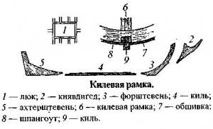
Transition planning and navigation in the intertidal zone involves two main tasks:
How to take into account the direction and speed of the tidal current?
How to determine the depth at a given point in at the moment time?
The almanac helps to cope with both of these tasks “ REEDS ", which contains tide tables and current atlases for different navigation areas. Let's try to figure out how the problem of determining depth is solved.
The annual almanac contains two types of pages of interest to us: tables of tide heights and hourly atlases of tidal currents for different areas. We will use tide tables and tide curves to calculate the time and height of the tide.
It may seem that solving the problem of determining the depth at the desired point at a selected point in time is only accessible to seriously savvy people. But I will try to show that, apart from being careful and following a clear algorithm when using tide tables, there is nothing complicated here. If only you had an almanac at hand and (at first) an example of solving a similar problem in front of your eyes.
It is impossible to provide tidal tables for all ports, harbors and water areas in almanacs. Otherwise you would end up with a ledger the size of.... In general, it would be a very, very multi-volume and cumbersome publication. Therefore, the tidal tables provide information for the current year according to the so-called. "primary ports". And for calculating the depths of “secondary ports” at different points in time, corrections are given. But first things first.
Taskfor primary ports:
As an example, let's look at a typical case. We have rented a yacht in St Malo in the north of France and want to know what time on the morning of Sunday April 24th we can leave the marina. Marina St Malo has a threshold of 2 m at the exit (Sill). During low tide, this threshold prevents water from leaving the marina and maintains guaranteed depths in the marina water area.
For safe passage over the threshold (as well as over any drying heights), we need to have a depth reserve of at least 1 m under the keel.
The draft of our 46-foot yacht is 1.90 m. That’s all the condition of the problem. It only remains to add that the underlined number 2 in the inscription Sill (2 m) gives the value of the drying height above the level of minimum depths (Chart Datum).
Yacht draft (Draft), 1.80
Safety Clearance, 1.00
Drying out height, threshold (Drying Heigt, Sill), 2.00
1.80+1.00+2.00= 4.80 m.
That. To exit the marina, the tide height at that moment must be 4.80 m.
Let us now turn to the almanac, to the tables of tide heights.
2. The next step is to find the port closest to the place of interest to us.
All almanacs are issued for individual navigation areas (areas) and contain data for major ports or for ports in special tidal conditions (Primery Ports or Standard Ports).
For all other ports and harbors (Secondary Ports), the tide height is calculated by reference to one of the primary ports.
Finding St Malo. St Malo is the primary port.
For primary ports, the almanac table provides data on the occurrence of low water and high water (Low Water and High Water). They are tied to standard time for each day of the year. Please note: some dates are highlighted in blue or red. The dates of spring tides are marked in red, and the dates of quadrature tides are marked in blue.
It is necessary to pay attention to the times indicated in the tables.
UTC (Universal Time Coordinated) or UT is the basis of civil time - the modern version of Greenwich Mean Time.
3. Convert ship's time to standard time.
All tide tables are constructed using the standard time in which people live in the sailing area of interest.
Time is summer and winter. The almanac gives winter time, and the summer one must be obtained from the almanac values. To do this, there is a reminder in the upper left part of the header:
Time zone ____
subtract (or add) __ hours for UT
For (region name) Summer Time add (orsubtract) ___ hour in non-shaded areas
That is (for example):
Time zone - 0100,
1 hour is subtracted from World Time.
For French summer time, add 1 hour to the unshaded zone data.
Attention! In the almanac, data related to winter time is shaded (so as not to be accidentally confused).

It is customary to write time in tables and maps without separating hours from minutes with dots or dashes: 1030.
3. Determining the time of low and high water

To determine the time of low and high water (LW and HW), you need to add one hour to the table time value.
And then the corrected time with the corresponding data (LW and HW) in the table would look like this.

From the values obtained in the table, it is clear that we can leave the marina at 12-18, when the depth of full water will be 9.8 m. But we calculated that to pass over the ill-fated threshold, it is enough for us that the tide height at the time of departure is 4.80 m. How can we determine this “right moment”?
4. Determining the time when the safe passage depth will be at the point we need
Let's look at the Tidal Curves.
This is a graph of changes in sea level height that is used to determine the height of the tide at present. Typically, two curves are indicated on the graph: red - for syzygy and blue - for quadrature.

We need to go out between the first low and first high water, that is, in the morning between 0644 (3.4 m) and 1218 (9.8 m).
On the lower axis of low water (L.W.Hts.m) we will put point A, corresponding to the first (morning) low water - 3.4 m.
On the upper axis of high water (Н.W.Hts.m) we will put point B, corresponding to the first (morning) high water - 9.8 m. We connect the points with a straight line. This line conventionally characterizes the rise in water level during high tide.
We are interested in the level of 4.80 m. We raise the perpendicular from the 4.80 mark to the intersection with straight line AB and find point C. From point C we draw a horizontal line to the intersection with the tidal curve.
Since our release date is close to the date of the quadrature tide (Tuesday, April 26), we can assume that the point of intersection of D with the blue quadrature curve will be close to the desired result.
Now, to determine the exact time of exit, you need to use the time axis located under the tidal curve.
In the center we see the time of high water (HW), it is determined from the table - 1218.
On the left, 6 hours ago is the time of the first low water (LW), on the right, 6 hours ahead is the time of the second low water for this day.
From point D of intersection with the tidal curve, we lower the perpendicular to the time axis and obtain the exact exit time when the tide level reaches the value we need.
It turned out that the tide will reach the required level 3 hours 50 minutes before the time of full water, i.e. at 8 hours 28 minutes. From now on, we can calmly and safely leave the marina, having a depth reserve of at least 1 meter when crossing the threshold. For convenience, there are empty rectangles under the time axis where you can enter the values of each moment in time before and after the onset of high water at 1218.
When preparing the article, materials from the textbook "Yachting School" were used.
and skipper's reference book, Andrey Ivanichkin
Bali is located in Indian Ocean between the island of Java and Lombok at latitude 8° south of the equator and at meridian 115° east longitude. The area of Bali is 5600 sq. km, the length of the island is 150 km from east to west and 80 km from north to south. The most high point in Bali - active volcano Agung (3142 m above sea level). Bali - tiny island, cut off from the civilizational world, the center of the Earth, paradise, the only place where it is worth being born and living. Here fabulous nature: mountains, volcanoes, gorges and wild rivers, rice terraces and impenetrable jungles, white, pink, black beaches and fiery sunsets in the evenings.
Weather in Bali by month
The climate in Bali is tropical. The average annual temperature is 27 - 31 C. The temperature varies within these figures throughout the year. Below is a graph that clearly shows the weather in Bali:
The so-called "rainy season" usually characterized by intermittent rain during the day. No need to worry about the rainy season. Many people imagine a tropical downpour that continues for months without stopping. Actually this is not true. During the rainy season in Bali, which occurs in late December - early January, precipitation occurs most often in the mornings. A little cloudier than usual in Bali, the sun is also warm and you can get sunburned even when there are thick clouds overhead. During the rainy season, which ends at the end of February, air humidity is slightly higher than in summer, as well as the air temperature rises by 1 - 2 degrees. The monthly precipitation graph is shown below:

The whole truth about the ocean in winter!
In general, there is no bad weather on the island of Bali, but there are some nuances in the seasons and the choice of areas and places where you can swim at one time or another of the year. Let us reveal the truth about Bali and tell you that if you come to the island in our Russian winter from December to March on the west coast of Kuta, Seminyak, Jimbaran, Changgu to swim in the clean ocean, then you will not be able to do this! Under no circumstances. You can safely forget about the clear ocean of these areas in winter! The fact is that in winter, from January to March, the direction of the wind changes, and the garbage that runs near Bali washes up on the shore. You can find a lot of garbage in the ocean: bottles, plastic, bamboo sticks, broken coconuts, bags and other nasty things. Therefore, if you still decide to relax in the winter west coast, then you will have to swim and enjoy the ocean in the following conditions:

If you are planning to have a really good, beautiful vacation, swim in the clean ocean, then in winter it’s a MUST!! go to the eastern part of Bali and southern part to the Bukit area. The area is well developed, so there is no need to travel to Kuta and Seminyak. Cafes, restaurants, shops, more than two dozen beaches await you in the south of Bali in the Bukit area. Here is a comparison photo between Kuta Beach and one of the southern beaches in the Bukit area.