The King's Path in which city in Spain? Royal Path in Spain
All over the world you can find unique attractions that arouse morbid interest among extreme sports enthusiasts. Many of them are the result of the centuries-old history of our planet and were created by the most skillful architect - Nature. But there are also such unusual creations, in the creation of which different generations of people were involved. And one of these magnificent creations, which we had the honor of seeing, is the system of unusual auxiliary slats and scaffolding that was used by builders during the construction of a dam in the Spanish province of Malaga. An inconspicuous outwardly steep rock with iron piles rusted over many years is known in Spain and far beyond its borders under the unusual name of the Royal Path.
A nice bonus only for our readers - a discount coupon when paying for tours on the website until July 31:
- AF500guruturizma - promotional code for 500 rubles for tours from 40,000 rubles
- AF2000TGuruturizma - promotional code for 2,000 rubles. for tours to Tunisia from 100,000 rubles.
And you will find many more profitable offers from all tour operators on the website. Compare, choose and book tours at the best prices!
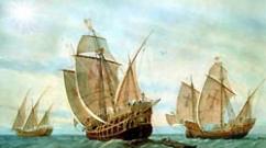
So, how did a unique creation of mankind’s hands appear, and even be able to get such unusual name? If we look at history, it turns out that piles and other auxiliary structures were created solely for construction. In particular, when the need arose at the end of the 18th century to erect the Conde del Guadalhorce dam, the issue of access for workers to the construction site had to be resolved. Due to the fact that the bulk of the work was carried out at a height of more than 100 meters, and it was necessary to go along the gorge to the dam, we had to approach the issue creatively. So, one after another, railway rails and piles appeared, along which the workers had to move.

If we managed to figure out the origin of the road, then we would have to really rack our brains with its name. After all, apparently, it should be associated with the Spanish monarch. But what did the king have to do with awkward platforms? Maybe it was he who came up with the idea to create a path from rails and piles? Or did he himself take part in the construction of the dam? No. As the primary sources say, the path actually owes its name to the king of Spain, but it was established after the monarch took part in the opening of the constructed dam. Since there was no other way to the dam, even a high-ranking official had to repeat the peculiar feat of dozens of workers and walk to it along narrow bridges, which were located at a mesmerizing height in the middle of the gorge.
Structural features

Today the trail is extremely popular among tourists who like to “tickle” their nerves and test their level of courage. Extreme sports enthusiasts come to Malaga from all corners of our planet and are eager to follow the path that workers took for several years to deliver materials and equipment for the construction of the dam. Every day they risked their lives, step by step, walking on unstable concrete floors, which are located at great heights.
El Caminito del Rey (the second name of the unique structure) has not been officially used since 1920. The network of iron supports and piles has a total length of more than three kilometers, and the width in some places does not exceed one meter. The path hugs the rocky outcrops of El Chorro and is considered one of the most dangerous places in the world. Despite the frightening reviews and notoriety, thousands of tourists come every year to see the amazing creation of the Spaniards. Although not everyone dares to set out on this exciting journey, for many, the interest and inspiring example of the Spanish monarch Alfonso XIII outweighs the fear and real risk to life.
Modern look

Over the years, part of the structure has collapsed. Therefore, the path became even more difficult and dangerous. And after the death of four visitors in 1999 and 2000, the government decided to limit tourist access to the Royal Trail. Access to the road was closed, and huge posters appeared in its vicinity, telling about its potential danger and threatening huge fines for all those who dare to violate the ban. But the daredevils, thirsty for new sensations, continued to find a way to get to the forbidden object. And as a reward for courage and zeal, every visitor to the attraction gets the opportunity to appreciate the amazing views that open onto the canyon.

Seeing such a serious desire of visitors to get into the intriguing and dangerous place, saluting their brave ancestors, the country's leaders nevertheless decided to restore El Caminito del Rey, which happened in 2011. To this end, a number of spans, where concrete slabs had collapsed and supports had rusted, were completely replaced. It is planned that the path will reopen to visitors in 2015. From now on, every extreme sports enthusiast will have the opportunity to legally get on a unique trail. But you need to be prepared for the fact that without a helmet and safety ropes you will not be allowed further than the sign.

In addition, in order to attract additional tourists and give the solemn event wide publicity, it was decided to allow everyone to appreciate the beauty of the picturesque canyon and make a risky journey to dizzying heights over the gorge is absolutely free. But you should hurry, because such generosity from the country’s leaders will last only a few months.
How to get there

There are several most popular routes. Particularly popular is traveling by train to the town of Alora, after which there are only 12 km left to the trail, which is easiest to overcome by taxi. You will have to walk for about 20 minutes.
Interesting articles:
- We are putting together a program for a tour of Spain
- Garajonay National Park, Spain
- Sculpture Kiss of Death, Spain
- Caves of Nerja, Spain
- Cape Creus in Spain
- Altamira Cave, Spain
- Alhambra fortress in Spain
- Red River Rio Tinto in Spain
Traveling by car would be more practical. First you have to get to the above-mentioned town of Alora, after which you turn left and drive through two small villages.

Please note that it is best to visit one of the local shops and purchase the necessary set of cables and safety carabiners. This set will cost approximately 65 euros. It is worth taking care of the right choice of shoes, giving preference to trekking boots. When going for a walk, do not forget to stock up on water and food, because the path is quite difficult and will take several hours.
The Royal Trail (Saminito del Rey), encircling the El Chorro rocks in the Spanish province of Andalusia, is considered one of the most dangerous in the world. The mountain crossing was built at the beginning of the 20th century as a relief route for workers involved in the construction of the Conde del Guadalhorce dam. During the opening ceremony in 1905, King Alfonso XIII of Spain walked along the trail - and in honor of this event, the road was named Royal. The passage, consisting of concrete slabs and railroad tracks and crutches driven into the rock, is located at an altitude of one hundred meters. The length of Caminito del Rey is 3 kilometers, and the width of the path is only a meter.
Since 1920, the moment construction was completed, the trail was not used for its intended purpose and was gradually destroyed. Now most of the concrete slabs and rails are loose or dismantled. Daredevils who dare to walk along the narrow passages are rewarded for their determination with the opportunity to admire the picturesque views of the canyon and the Guadalhorce River. If, of course, they manage to take their eyes off the carbine and the dilapidated steps.
Those who want to walk along the dangerous path should hurry up: restoration work to restore it began in 2011. The three-year project includes the organization of a safe tourist route along the Royal Trail, as well as the construction of attractions with colorful light shows and tourist service points.
Since 2000, passage through Caminito del Rey has been officially prohibited. However, in reality it is not difficult to get onto the path; the passages are open on both the northern and southern sides. The maximum that protects tourists from entering the road is warning signs and fences. All further actions are the personal responsibility of each traveler. In some places, the Caminito del Rey narrows - and you can only walk along it by balancing over the abyss, on thin metal reinforcement. Despite your physical abilities and climbing experience, it is recommended to use a climbing harness, since cables and crampons are found along most of the trail. But be careful, the cables will only save you if there are not many people in the company: large number a person will not be able to withstand thin ropes.
You can buy a harness with carabiners and rope in a shop near the start of the route. A standard set will cost 65 euros. The only thing you should take care of in advance is non-slip trekking boots.
When going for a walk along the Royal Path, be sure to take water and a sun hat with you. The round trip will take at least a couple of hours.
You should not start in the rain or immediately after it. Walking along slippery rocks and concrete slabs is not best option test yourself for strength and luck.
How to get there
There are several ways to get to the King's Path. The first is by train to the town of Alora, from where the trailhead is only 12 km away. This distance can be covered by taxi (approximate cost - 20 euros), which will take you to the beginning of the route. Then it's about twenty minutes on foot to the trail.
If you are planning to get to the Royal Path by car, starting from the southern coast of Spain, take the A-343 highway. After passing the town of Alora, turn left and continue until the village of Caracuel. Next, after passing the small village of Bermejo, continue along the Guadalhorce River and the mountain railway to Caminito del Rey.
If you just want to enjoy the views of the trail, then continue left. After a few kilometers you can find a small restaurant with delicious food, whose veranda offers picturesque views of the rocks.
If you plan to walk along the trail, turn right and continue along the road. A couple of hundred meters after El Chorro base camp, park your car in a small clearing under eucalyptus trees overlooking the railway tracks. Once you reach the railway level, you will find yourself at the beginning of the Caminito del Rey. But be careful: on this side the trail is quite dangerous, and a walk without climbing equipment can end tragically.
For those who do not have rock climbing experience, it is better not to risk it and try to climb from the end of the trail. The best way to reach it is from the outside of the railway bridge. After passing through two tunnels (watch out for trains!), go down to the Guadalhorce River. After wading through it (the narrowest place is not far from the gorge), go up, focusing on the abandoned building. At the top is the entrance to the trail; The width of the concrete slabs here is about a meter. In this section, the fallen sections allow you to do without a harness, but it’s better not to take risks and use climbing equipment.
Location
The Caminito del Rey trail encircles the El Chorro rocks, located in the central part of the Spanish province of Andalusia, 50 km from.
The opening of the reformed Royal Trail, known as El Camino del Rey, has been one of the most anticipated events in recent years.
The new trail has made headlines in newspapers and magazines around the world, and Lonely Planet recently included Caminito in its "Hottest things to do in 2015" list.
Official opening The Royal Path took place on March 28, 2015. What to expect...
A little about El Caminito del Rey
The Caminito was built between 1901-1905 and was used to transport materials and people between two power plants that were built on either side of the El Chorro gorge. The official opening took place only in the early 1920s. King Alfonso XIII of Spain attended the opening ceremony and walked along this path, giving it his name (King's Path). From that moment on, the Camino became one of the wonders of Spain.
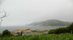
Gorge El Chorro (La Garganta del Chorro) - amazing place with huge stone walls 3 km long and 400 meters high. El Chorro can be translated as “the rush,” which is the most appropriate word to describe how water flows through narrow gorges and ravines. The difference in altitude between the two main reservoirs created by man at different ends of the gorge provides a unique opportunity for the development of hydroelectric power stations. It was almost a revolutionary concept at the time.

An ingenious construction, but nevertheless, the most attractive part of this design is the path itself, El Caminito del Rey, which runs along the entire gorge. It is said that the original structure was built by sailors who had to climb and work suspended above the void. Some sources (unconfirmed) claim that prisoners sentenced to death also participated in construction work and performed the most dangerous tasks.
The trail was built using sand and cement and held in place by metal brackets. Railway rails were also used without unnecessary frills. Over the course of several years, Caminito slowly but surely fell into disrepair, and was officially closed in 2000 after the death of several people.
Such danger and risk have become the stuff of many legends and have attracted many climbers and adrenaline junkies from all over the world. Many people refer to Caminito as the most dangerous trail in the world, attracting all these adventurers. This is what Caminito looked like in 2013 before reconstruction began.
The government has been raising the issue of reconstructing the Camino for years. And at the end of 2013, it finally realized its plans. Local authorities and Malaga shared the cost of reform - €5.5 million. 2.2€ was used to build a new Caminito and the rest was used to additional services in the area, roads, parking and everything needed for buses. According to preliminary estimates, about 250,000 people will visit Caminito in the first year after opening alone, adding €20 million to the coffers and creating 180 jobs. This will become the number one attraction in all of Andalusia, if not in all of Spain.
Tickets
The maximum number of people that can be on Caminito at the same time is 400 people. Groups of up to 50 people can pass through the initial control posts at intervals of half an hour. It is estimated that in the first six months the Royal Path will receive 600 guests per day.
Opening hours and dates
On at the moment:
New Caminito del Rey

The total length of the new trail is 7.7 km. You're moving from Ardalesfrom north to southAlora(Álora).
Route: from Ardales to Alora
This route goes down the river and takes about 4 hours. It starts close to the MA-444 access road, which passes by Ardales Lakes. From here there are several ways to get to the start of Caminito. You first need to get to the other side of the mountain.

Not far from the Kiosk restaurant, right next to the Conde de Guadalhorce reservoir, there is small tunnel. It is short, but you need to continue on your way, about 2.5 km more. This road is very picturesque, plus it is marked with signs. Follow the river and you will reach a control post/entrance.
There are also longer tunnel, which is located next to the Mirador restaurant. It's a little longer than the Kiosk one , but overall you will save a little time. At the time of writing, there was no lighting in the tunnels. Therefore, if you are not confident in your night vision abilities, take a torch or flashlight with you.
If you're not a big fan of tunnels, you can walk through the mountains down to the river. Follow the path behind the Mirador restaurant. You won't miss it.

The control center is located next to the old hydroelectric power station. As soon as you pass by, the path begins to narrow and it becomes like walking up a mountain, which it is, as you get closer to Desfiladero de los Gaitanes. And eventually you find yourself in a valley Valle del Hoyo.
The old Caminito was left unchanged as much as possible, and a new path was built directly above the old one. It is predominantly made of wooden panels with supports drilled into the rock. The one meter wide path offers you breathtaking views through the glass floor at some points on the road. And your adventure ends with a beautiful bridge hanging over the Balconcillo de los Gaitanes.
This spectacle is definitely not for the faint of heart - the bridge hangs at a height of 100 meters over the Gaintanes gorge.
Always remember
- It is not recommended to visit the trails if you suffer from dizziness or are very nervous.
- At the beginning you are given a helmet - do not take it off throughout the entire journey.
- There are no bathrooms along the entire route.
- Bring water and food with you.
- If you are arriving by train, make sure you book your tickets from Alor.
- El Chorro railway station will be renamed El Chorro - Caminito del Rey station.
- Children are only allowed over 8 years old and accompanied by an adult.
- The trail may be closed if winds reach above 35 km/h.
- The walk is linear. You start in the north and end in the south.
- Exists bus service, connecting the two sides. It departs every half hour and the ticket price is €1.55.
- Bus from El Chorro departs before arriving at the railway station.
- The bus leaves from Ardales from El Sillon del Rey- King's Chair - a few hundred meters down the road from the Kiosk restaurant. El Sillón del Rey features a stone table and chair dedicated to the discovery of the reservoir. They had to be pulled out of the same reservoir after they were thrown there during the Spanish Civil War.

By car
From Málaga, take the A-357 north towards Cártama. You need to travel 65 km along the highway. Once you pass the village of Ardales (on the left side of the road), be careful not to miss the sharp right turn (signpost - M-442 / Ardales / MA-5403 / El Chorro).
Then turn left onto the secondary road MA-444, which quickly circles around the Guadalhorce reservoir, giving you the opportunity to enjoy fantastic scenery. Continue along this road as it winds around the lake. You will eventually reach a junction with a sharp right turn towards the village of El Chorro. Instead of turning right, continue along MA-444, driving past the camping and beach areas.
Just before the small tunnel, make a sharp turn right onto the dirt road. You will see signs "Restaurante El Mirador". You need to drive a couple of hundred meters and you can park your car (anywhere). The tunnel is clearly visible, plus it is marked with signs.
There are plans to build two large parking lots in the future. To receive additional information for routes, visit the official Caminito page.
Trains to El Chorro - Caminito del Rey from Malaga
Currently there is only 2 trains depart daily from Maria Zambrano station in Malaga to El Chorro - Caminito del Rey. The first one starts at 10.05 - destination - Ronda; the second - at 16.48 in Sevilla Santa Justa. The journey takes 40 minutes, ticket price is 6€.
There are three trains back to Malaga from El Chorro: at 9.33, at 15.03 and 18.03.
Additional trains are only in the plans for now. For more detailed information visit Renfe website or call 902 320 320.
El Chorro - Caminito del Rey
Road of Kings ( Royal Path, Caminito del Rey ) - the most “scary” mountain trail on suspended walkways. It winds its way around the steep slopes of the gorge in El Chorro in the province of Malaga.
El Chorro Gorge in Spain
How many frightening and soul-chilling stories have accumulated on the Internet about this trail, but in fact it is securely fenced with a dense mesh metal partition with railings that you can hold on to while walking, and the road is well fortified. The safety and reliability of the road is constantly monitored: local authorities also do not need unpleasant incidents. In 2001, 5 tourists fell off the trail, the authorities closed it to the public, but then a reasonable decision was made - the road was reconstructed and fenced off with reliable partitions. Since 2015, tourist groups began to be taken to the trail again: now it’s not scary at all.
However, you can really tickle your nerves: just look down from the road at  rocky bottom of the gorge. The height takes your breath away! Many tourists are frightened by the suspension bridge over the gorge. Although it is metal, on strong ropes, it sways in the wind. Creepy, but very exciting!
Why is the road to El Chorro called the Path of the Kings? Story!
A suspended road was built at the beginning of the 20th century to serve the Conde reservoir and dam on the Guadalhorce River. King Alfonso XIII was the first to step on the path, and the road was immediately christened Royal. Beautiful name is still with her to this day.Neighborhood El Chorro abound in mountain streams  rivers, there are two gorgeous waterfalls here - Chorro and Gaitanejo. Three reservoirs are still operational and blocked by dams.
 An amazing view opens from the trail: all around there are picturesque cliffs, broken lines of rocks, ribbons of blue rivers. There is not much vegetation on the rocks, but it is lush, emerald shades, rich and lush. Selfie lovers will definitely love it here!
How to get to El Chorro and the Royal Path? 
Get to El Chorro by car or by train from Malaga: the train stops at the station of the same name El Chorro. It's more expensive by train, but renting a car for several people is more profitable, and you can get to the place faster. You can leave your car in the station parking lot (there are both paid and free places), then follow the road following the signs.  Traffic along the trail usually goes only in one direction: from north to south. The tourists are taken back along an asphalt road by a bus; the traffic goes around the cliff with a path, but the buses may not run, then they will have to go back along the same route.
Cost of entry to the Royal Path
Tickets for the Trail of Kings should be purchased in advance (preferably 1.5–2 months in advance) on the website caminitodelrey.info. Please note that children under 8 years old are not allowed on the trail.A ticket costs €10 for the trail itself. The cost of a bus ticket is €1.5.
 People are allowed onto the road itself strictly according to a schedule: in small groups at a certain time. After parking, you are led through a small tunnel in the rock, then we reach the trail along a passable road. Here - before entering the path - there is the first and only toilet, which should be visited without fail: on the road itself there will be no such opportunity, and you will have to walk along it for about two hours, plus then have to go back by bus, which is another hour - one and a half.
From the train station and adjacent parking lot  to the entrance to the trail - approximately 2 kilometers. Approximately in the middle of the road to the trail, a Visitor Reception Center has been built, where you can listen to an introductory lecture about the trail, watch a visual tour, and admire the surrounding area from panoramic windows. Here you will be given a printout of your armor and given helmets with disposable liners. After completing the trail, helmets are handed over and placed in a large basket.
You won’t be able to get onto the trail without armor: the registration is strict. This is done for the safety of tourists: the trail can only support a certain number of people at a time.
 Why do they give out helmets before going out on the trail? It seems that precautions are optional, but they may still be needed. What if a stone falls off a cliff?
Helmets are issued for a fee on the security of your passport if you do not have a reservation (purchased ticket), but this can only be done in the mornings, when there are few visitors.
If there are day groups, then this option is not possible. Anyone wearing a branded helmet is allowed onto the trail itself; they are no longer checked. entrance ticket. There is only one road here, so getting a helmet by trickery (asking one of the tourists who has already walked along the trail and is returning) will not work. And there is no need to take such risks.
 In the summer, the trail is usually scorching hot: only a strong wind can save you from the heat, so you should dress in thick windbreakers and trousers, it’s even better to take a scarf. The best time to visit is May and June. It's neither hot nor cold.
What you will see on the Royal Trail
Birds of prey circling over rocky landscapes. There are a lot of them here: they hunt rodents, which you can’t see from above, and they catch fish.Magnificent panoramas of rocky cliffs and time-carved cliffs, alternating with wooded plateaus.
From time to time, pieces of the railway are visible, diving into tunnels under the rock. Extreme sports enthusiasts manage to walk (illegally) even on them, but we categorically do not recommend doing this.
Here and there there are benches along the trail: you can rest, have a snack, and admire the surroundings.
The movement along the road ends with a passage through the tunnel, then we get to the place  bus parking. And here you can finally go up to the observation deck: from it you can see the Embalse Tajo de la Encantada reservoir.
What else is worth knowing about El Chorro and the Royal Trail
During the time when Royal Path was closed, illegal extreme sports enthusiasts were fined €6,000. Part of the old trail was deliberately destroyed to make it impossible to walk along it. New protected paths were laid over the old road, and an iron bridge was suspended at the beginning of the path instead of the old arched bridge. And although it is firmly fixed, when you walk along it under gusts of wind, the sensations arise eerie. The first part of the bridge leads out into the valley, where here and there you can see ancient communication structures that were previously used to operate the dam. Now they are neglected and overgrown with greenery.
The valley ends in a gorge, and the road again turns into a canopy path with railings over another gorge. In this part of the trail you can see old bridges, railway, running into a tunnel, an old path.
Please note that the bus may not always be in service and there may be renovations going on, so you should take into account the total time it takes to complete the trail there and back. It will take three to four hours to walk one way only, taking into account the time it takes to cover the distance from the Visitor Center to the trailhead at one entrance and the same time from the end of the trail to the other Visitor Center. These distances are another 2.7 and 2.1 kilometers, plus the duration of the road itself from the northern passage to the southern one - 2.9 km.
Here's the total length of the route - 7.7 kilometers, but the interesting part is located  only between the northern and southern entrances. Please note that part of the road is going uphill at a slight incline - it is much more difficult than going uphill with a large degree of incline. If you don't walk much, you will get very tired. Get ready for the load!
Bring plenty of drinking water, a white scarf, facial tissues, and face freshener.
The train and bus schedule is posted on the official website, you can also find out in Malaga at any railway station how to get to El Chorro
caminitodelrey.info/en/5243/frequent-questions
Tour groups visit the trail every 15–30 minutes. The road is open every day, with a few exceptions. holidays per year. It is also closed for renovations and due to unfavorable weather conditions. weather conditions(in storms and strong winds). But this happens rarely.
Lake in the El Chorro mountains
 Walk along Caminito del Rey (Royal Path to El Chorro
) must be combined with a visit mountain lake. IN summer period it’s very nice here, and stunning views will brighten up a sea holiday on the coast Mediterranean Sea. The water on the lake is very clear and refreshing - a fresh paradise!
Walk along Caminito del Rey (Royal Path to El Chorro
) must be combined with a visit mountain lake. IN summer period it’s very nice here, and stunning views will brighten up a sea holiday on the coast Mediterranean Sea. The water on the lake is very clear and refreshing - a fresh paradise! There are a large number of restaurants with reasonable prices near the lake, on the lake itself you can rent a catamaran or paddle boards, on the lake itself there are many places for a picnic and you can barbecue. Parking for a car will cost 2 euros, and entrance to the equipped area will cost 1 euro per person. On weekends there are a lot of people here, as they gather local residents who try not to visit the sea coast.
At the top of the mountain there is a Spanish bar, Bar La  Mesa, where they serve delicious coffee and Spanish dishes. This is an ordinary Spanish house, a family lives there and welcomes guests El Chorro- you can’t make a mistake on the roads, but you’ll have to drive along serpentine roads and come to a dead end, there will be observation deck and a small path to Bar La Mesa.
From a bird's eye view you will be able to see the whole mountain range and a small train station El Chorro, where trains arrive from Malaga - this is if you are going to go on your own, but it is better to rent a car on any beach, then your coverage will be greater.
 Charge your equipment well, you will take a lot of photographs - 100%, because after looking at our photos and videos with El Chorro, you will definitely want to diversify your collection!
Enjoy your holiday and new discoveries - subscribe to our Instagram profile and read this site.
All the best to you!!!
Video of the Royal Path to El Chorro
Video from El Chorro - Trail of Kings No. 1
Video from El Chorro - Trail of Kings No. 2 Video from El Chorro - Trail of Kings No. 3 Video from El Chorro - Path of Kings No. 4
Just a year ago Royal Path (El Caminito del Rey), laid along sheer cliffs in the El Chorro gorge in the province of Malaga in Spain, was considered the most dangerous hiking trail in the world. At the beginning of the 20th century, it was built here to serve the Conde Dam on the Guadalhorce River and received its name in honor of King Alfonso XIII, who was one of the first to attend the opening ceremony here. Subsequently, the path became tourist route, but his condition worsened every year. Finally, in 2001, after five tourists died here within two years, the Spanish authorities decided to close the Royal Path to visitors. But, despite the ban, this place continued to attract thrill-seekers, and for many of them it ended in tears. And then, convinced that this forbidden fruit would continue to attract maniac rock climbers, a wise decision was made to reconstruct the trail. Construction work began in February 2014, and on March 28, 2015, Caminito del Rey was reopened to visitors.
The news about the opening of the Royal Trail appeared a few days before the start of our trip, and I decided to visit here at all costs, especially since this place was located right on our way from Granada to Ronda. You can get here by car or by train to the station El Chorro.

You can leave your car in the parking lot near the station, and then signs will lead to the beginning of the route. Along the way you can see a beautiful railway bridge.

Already from afar, when you see the path suspended from the steep cliffs, it begins to take your breath away.

In the first six months after opening, you can visit the Royal Path for free, later, most likely, they will begin to charge an entrance fee and, according to experts, this tourist site will be able to annually bring up to 20 million euros to the provincial budget. There are already more than enough people wanting to get here, and 400 visitors are allowed on the route at the same time, so a pre-registration system has been created. The official website suggests signing up for a specific day and time, but at the moment all places have already been booked until the end of September. When I started getting interested, it was still possible to sign up a month in advance, but since we didn’t yet know when we would get there, I didn’t sign up. But, as you understand, I still walked the route, so my experience may help those who, for some reason, also could not or did not have time to book a ticket. By the way, children under 8 years of age are generally prohibited from entering here, so there was no way for us to get here as a whole family. I had to leave the children with Yulia and break through alone.

The distance from the railway station and parking to the entrance is about two kilometers. Somewhere in the middle there is an information point. They come here with a printout of their armor and receive helmets and disposable pads for them, and on way back These same helmets are handed over here, put in a large basket. I decided to first try to get in honestly and said that I don’t have a reservation, but I’m dying to get here, please let me through, huh? But the young man at the counter said he couldn't help.
Frustrated, I, together with Yulia and the children, walked to the entrance to the route and noticed that here it seems that reservations are no longer checked, but everyone who is wearing a branded helmet is allowed through. This is what I decided to use. I asked the young people already returning back if one of them could give me a helmet, because they are no longer checked on the way out. But it turned out that they received helmets on the security of their passports and said that they also did not have a reservation, but they and many other visitors were also allowed to pass, leaving a deposit. Then I returned to the information desk and told the guy: hey, bro, let me through, please, here, take your passport too, just let me look at the beauty. But he was relentless: people were allowed in on bail only in the morning, but now there are too many with tickets, so excuse me.
Then I went outside and, without hesitation, simply took one of the helmets out of the basket where they are left, and confidently walked towards the entrance. There, a young employee asked in Spanish something about the “reservación,” but, seeing my confusion, asked in English: “Did you leave your pass on the information?” I just nodded to this and walked through the turnstile.

The length of the Caminito del Rey route is 7.7 km, of which the most interesting part is between the northern and southern entrances of 2.9 km (suspended boardwalks - valley - suspended boardwalks). I, like most other visitors, entered through south entrance(Álora), walked through the valley to the northern one (Ardales), and returned back the same way. It took me 2 hours, but I was in a hurry so that my wife and children would not get bored, but in general you could spend at least the whole day here. By the way, you can return back by bus (here is the schedule).

At the very beginning of the path there is a bridge between the rocks. More precisely, now there are two of them.

The old arch bridge is replaced by a new suspension bridge.


As you can see, new path It is laid half a meter higher than the old one and has reliable railings along its entire length, so the age limit for visitors is not entirely clear.

In the following photos you can see the condition of the old trail.


During the period when the Royal Path was closed, the first part of the path was deliberately destroyed to make it even more difficult to get here, and the fine for entering here was 6,000 euros. But this did not stop the crazy extreme sports enthusiasts. Unfortunately, for some of them the price of entry here has become unreasonably high.

Along the entire length of Caminito del Rey, a railroad runs parallel to it. The next photo shows another bridge between the tunnels.

After the first section with suspended decks, a picturesque valley begins.

Along the entire path along the valley there are parallel engineering structures that were previously used to operate the dam.


The entire trail was even once electrified.

The valley ends with another gorge.

This is where decking with railings reappears.


Another old bridge, which is currently prohibited.

And again on the left walking trail, and on the right is the railway.

In this part the trail resembles the Partnachklamm gorge in Bavaria. Moreover, the fences there are not as reliable as here, but we walked there calmly with four-year-old Leo and newborn Martin.


I reached the northern entrance, I can turn around and stomp back to my family.