Hiking trail with ai petri. Walking to Ai-Petri
At the beginning of September 2012, I walked to Ai-Petri.
I started my route from the famous sign “Sevastopol-72, Yalta-9”, which is located on the Sevastopol-Yalta highway. See photo.
How to get there? The easiest way is by minibus. I printed out a photo of this place and took it with me. I came to the bus station, showed the drivers a photo and asked how to get to this place.
If you go on foot, the cables of the famous cable car. You can't help but see them, no matter how you travel. From the place where the cables are stretched over the highway, you need to move 1.5 km towards Yalta.
Below in the comments Artem suggests: this place is turn to Miskhor and Koreiz.


Behind the sign, two dirt roads begin; you need to choose the one to the left.
At the beginning of the trail, white brick structures were built. Likely, local residents tried to capture land plots, guided by logic: if my property is on the ground, then I lay claim to the land. This number did not work for them. And very good!

When you stand at the very beginning of the route, the distance to be covered is impressive. You look and don’t understand how you will end up on this rock? How is this possible?


However, it's not that difficult. I started the route at about 11.30, reached the upper cable car station at 14.00. Thus, the ascent took about 2.5 hours. I took my time, took a lot of photographs along the way, looked at the surrounding views, and took breaks.
I read that the Koreiz trail is 3.7 km long. On flat ground, walking such a distance is generally a trifle, but in the mountains main factor- height difference, not linear distance.
To the place indicated on the diagram as a “spring”, the road is well trodden, so you won’t get lost in this area. The route is considered to be marked with white markers. Yes, there are marks, but they are placed in places where there are no forks in the road, that is, where they are not needed. And at the forks they are just not there. Listen to your intuition. We need to go around Ai-Petri on the right, so left turns are not ours. Too sharp branches of the path to the right are also not for us. The general direction to the “spring” point, as shown in the diagram (see photo above), is straight and slightly to the right.
The appearance of the spring did not inspire me at all; it was dirty and dry. I mentally called this place “the gazebo.”

If you stand with your back to the entrance to the gazebo, a sharp upward climb begins right in front of you. This climb was not part of my plans. From the spring I was going to walk along a relatively flat, well-trodden path. I don't know where it would take me. But while I was sitting in the gazebo, three guys walked past me. It was clear that they were very confident in themselves and knew exactly where to go. I said hello, they returned the greeting. They said that they were going “through Maly” (meaning Maly Ai-Petri, aka Raven Rock), and rushed up, encouraging each other with shouts like “turn on second gear and row.”
The ascent that opens before your eyes when you stand with your back to the gazebo is frightening. There was an alternative - to gofrom the gazebo along another path, relatively flat.But I decided to walk without losing sight of the guys, since, unlike me, they knew exactly the way. Immediately after the gazebo, the area is difficult, the slope is too sharp. You need to overcome this part of the path, then it will be easier, then the path becomes flatter.
One of the guys held a long wooden stick in his hands and used it to push off. Smart approach. Behind the spring gazebo, a staff in your hands is not at all superfluous. Like a third leg.
After some time, he went to Small Ai-Petri (or Crow Stone). To get there from the “gazebo” along the straightforward route I had chosen, I didn’t have to strain my brain, think a lot, look for a path, or look at the map. Row yourself up and up.
Stunning views open before your eyes! This cannot be conveyed through photographs and cannot be described in words.

And here I am on the edge of Small Ai-Petri!!! My pose is not staged. I look down with fear that is quite real.

From Malyi Ai-Petri the further route is already clearly visible.


The next photo shows a top view of the Crow Stone (or Small Ai-Petri). The triangular stone ledge is what it is, I just took a photo on it.
As already noted, the entire ascent took 2.5 hours. Of these, I walked 1.5 hours from the highway to Maly Ai-Petri, and 1 hour from Maly Ai-Petri to the cable car station.

The higher you go, the more beautiful the views. You look at the distance traveled from above, and you begin to be a little proud of yourself.

As you climb, the characteristic South Shore nature gives way to foliage. As you increase in height you find yourself in another climate zone– from the subtropics of the South Coast to the middle zone.

Here the guys, looking at whom I gained courage and rushed up a steep climb from the spring, began to collect mushrooms. It turned out that they were local residents. They advised me not to walk around uselessly, but to take a knife, a bag and get down to business - collecting “pasture”. I didn’t pick any mushrooms; that wasn’t my plan. For them, going to Ai-Petri is an everyday matter, picking mushrooms. And for me - an impression for life.
In the “middle climatic zone,” swarms of annoying, impudent flies appeared, which were never seen on the coast. As long as you walk, it’s normal, as soon as you stop, they climb from all sides.
And here is the cable car station! The ascent is over.


The fee for access to the battlements is 20 hryvnia. The money is small, but I immediately remembered Ostap Bender, who sold tickets to view the Proval. My elated and enthusiastic mood did not correlate with some vulgar tickets. I didn't go to the battlements.
The great schemer explained that the money goes to strengthening the Failure so that it does not fail too much. Where does the money for examining the teeth go? To sharpen them so they don't get too dull?

Out of curiosity, I asked how much a minibus to Simeiz cost. When asked to sit in the salon, I replied that I would leave on foot, as I had come. The driver's expression became somewhat puzzled.
I considered the option of going down the cable car, but when I saw the queue, I immediately abandoned this idea.

I didn’t walk here along the trail to end my journey in this long line.
I went down the same road I came in.

Walked from the top of Ai-Petriall the way to Simeiz. Stopping a minibus or hitchhiking on such a dayIt seemed indecent to me.Having gone down, I first walked along the paths that run along the highway, part of the way I walked along the side of the highway. Looking back, I was surprised that I was able to trample so much.

Something like this. Go around the mountain on the right (red arrow in the next photo).

Greetings! Not all drivers decide to climb the Ai-Petri plateau by car; there are also those for whom the trip becomes entertainment. Undoubtedly, the route is memorable and picturesque - the higher you climb, the more you admire the panorama of the southern coast of Crimea.
Dear readers! The article was written a long time ago, but is still in demand, so I constantly update it and include relevant information. Updated 08/15/2019
There are four ways to climb Ai-Petri: on foot, in your own car, by cable car or with private carriers. Each option has its pros and cons, but you should definitely use at least one. There are diagrams for walking routes on the Internet.
From August 16, 2019, MUP "Yaltagortrans" will provide transportation from Miskhor and the Yalta bus station to the Ai-Petri plateau using a licensed taxi. The price of a one-way trip is 450 rubles. per person.
“Taxis will be dispatched as they are loaded from the points of sale of subscriptions. In the area of the Ai-Petri plateau, dispatch and boarding of passengers will be carried out. In the future, the directions and types of transportation by licensed taxis will expand.”
Due to the lack of snow in Crimean resorts at the beginning of January 2019, the Ai-Petri plateau became the most popular place for active recreation. Hundreds of tourists posted their pictures on social networks from the snow-covered mountain: some on sleds, some on skis, and some in a kilometer-long traffic jam.
On January 2, 2019, on the Ai-Petri plateau, traffic was paralyzed; there were weirdos who climbed up on summer tires (they had to be pulled out).
photo from the VK group “Weather on Ai-Petri”.


Dear, before traveling to winter time Check the weather conditions online! If you don't care about yourself, think about your children! Rescue services cannot reach some areas.
Count on capabilities of your car: 4x4, spikes or chains, full tank.
Current weather information on Ai-Petri: https://ru.snow-forecast.com/resorts/Ay-Petri/6day/mid or in the specified group on VK.

On January 4, 2019, 6 avalanches occurred, the transport could not get out on its own, they called in heavy equipment and augers to break through to the stuck people. Avalanches covered many vehicles.

Previously, there was an unspoken rule for visiting Ai-Petri: ascent to the plateau along a narrow serpentine road before 12 noon, descent - after 12 noon. Now motorists ignore this rule and create problems for themselves, others and rescue services.
Our trip to Ai-Petri took place in mid-March; we were lucky with the road - we encountered snow jams only on the northern descent.

The mountain serpentine leading to the plateau is the longest and most winding in Crimea. Depending on weather conditions, some sections or the entire road may be closed, as warned by a sign at the beginning of the path or by guards. There are landslides, landslides and avalanches here.
Road T 0117 leads to the Ai-Petri plateau, and then along northern slope, through Grand Canyon Crimea, in the Bakhchisaray district. The second name is the old Yalta highway. Along the route there are springs, interesting rocks and the most famous waterfalls of Crimea: (on the southern slope) and Silver Streams (on the northern slope).
We can say with all confidence that the road to Ai-Petri is one of the most dangerous roads in Crimea, so tired drivers and beginners have nothing to do there!
We headed to the top of Ai-Petri after a walk along the Yalta embankment in the afternoon. A cold wind was blowing from the sea and I was afraid that we would freeze completely at the top, but it turned out the opposite.
For those who don’t know what the serpentine road on Ai-Petri looks like, here is a map of our route.
Halfway through the route we stopped to take a few photos; we didn’t have such an opportunity any further due to the nature of the route. There are “pockets”, but it’s better not to occupy them, you never know who will fall on your head...
Photos from the VKontakte group “Weather on Ai-Petri” were taken on December 2, 2018. From Bakhchisarai the road to Ai-Petri is much worse, there are many potholes.


Information has appeared on the Internet that in the winter of 2019 the road to Ai-Petri will not be closed.
This year, Krymavtodor specialists decided to change the rule. Weather stations will be installed on the approaches to the mountain, which will forecast the weather and the condition of the road surface. This will allow road workers to react in time, process the road and bring it into working condition.
In March, there were whole glades of snowdrops in the forest, but the phrase “oh, what flowers, let’s stop” was clearly not appropriate. 
In some areas there was no fencing at all. To my question: “Why are there no bump stops?” my friend answered: “If we fly down, they won’t help us.” Thank you, I reassured you...

All we had to do was wait until we climbed Ai-Petri. In my mind I imagined what the plateau looked like, because the last time I was there was years….twenty years ago. Having driven up the mountain, we left the cars in a free area next to the administration of the meteorological station.


Then the fun began. If you go right, you will get to the observation deck. Usually, this is the name for a place that is fenced and allows you to see the immediate surroundings in full scale.
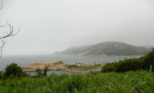
With the so-called observation deck A clear expanse opened up - a turquoise sky with glimpses of azure was buried in the sea surface of the Black Sea. Evergreen bushes and trees framed Alupka and Koreiz with their thickets.

Silence and tranquility... To the right, in the distance, the teeth of Ai-Petri are clearly visible, it is there that the upper station of the cable car is located, the most high point 1234 m and Trekhglazka cave. 
If you go straight, you'll end up in a showdown.
This is the architectural structure left after someone's division. Until 2011, there was a ski club on this site. Apparently, now these ruins will serve as an edification to descendants.

What happened next was completely sad. Rows of cafes and trade stalls with strange souvenirs that have nothing in common with the products of Crimean craftsmen. Special flavor national cuisine I didn’t notice either, so I didn’t go anywhere for lunch; I can’t evaluate the dishes on offer. In August 2019, nothing has changed.


There is neglect and chaos all around. Private houses, barns, cafes, shalmans, construction sites. After just 15 minutes you forget what kind of devil you came up here for.
The “highlanders” do not want to improve the territory because of unresolved land issues. Environmentalists are sounding the alarm and calling for a halt to economic activity on the territory of Ai-Petri and to limit the carrying capacity for the development of eco-tourism. But we realized it too late: many entrepreneurs have been working here for decades. The circle has closed and now all hope lies in the new government, which will make a rational decision so that “the wolves are fed and the sheep are safe”...
There is another “architectural landmark” on the edge of the cliff. It was built on a grand scale so that the mountains, sea and sun were visible from all the windows.

The faded sign says: Jolly Roger Cafe with the best recipes of oriental cuisine.

There is another viewpoint nearby.


Here you can turn to the sea and escape from reality, but only in one direction, because on other sides all the beauty of the plateau is obscured by construction and private houses.


Due to the peculiarity of the relief, Ai-Petri is called yayla - summer pasture. Since ancient times, settlements have been built on the plateau, but the biggest “contribution” was made by homo sapiens.

Back in 2014, the media reported that the Ai-Petri plateau had been put in order, all construction waste had been removed and there were no illegal buildings. Was it even more interesting...
Perhaps the only object that is in its place is the monument to the Crimean partisans of the Great Patriotic War who died in battle in December 1941.

The road to Ai-Petri was important during the Second World War. It was along this route that the Nazis transferred troops and equipment towards Sevastopol. The partisans managed to blow up a section of the road and prevent the enemy’s plans from being realized, but they all died in an unequal battle.
At the cost of incredible efforts, the soldiers were able to protect their land; their memory should be passed on from generation to generation, and not disappear under scaffolding...

Returning to the parking lot, we set off by car across the entire plain of the plateau.

The further north you went, the more snow there became. In the lowlands, where the snow had not yet melted, snowboarders were riding on the slopes. The first snow falls on Ai-Petri in October, and a stable layer remains from mid-December until March-April.

And we had a long descent ahead along the mountain serpentine towards the Bakhchisary district. At the beginning of the road there was a track of snow and ice.
Previously, when bad weather conditions For private cars, the road to Ai-Petri was blocked from both Yalta and Bakhchisarai. The traffic police was on duty everywhere. You can climb Ai-Petri by cable car or by transport that provides transportation.
The transfer organizers do not hide the fact that the route is actually closed. At the same time, it was not possible to find out exactly how carriers “make their way” through traffic police posts: “We have different moves. No matter how, we will get there."
About 35 km from the top of Ai-Petri, there is a parking lot and a hiking trail to the Grand Canyon of Crimea. I have already talked about this route in my report.
Of course, in March it is not as interesting as in October.
What's happening on Ai-Petri in August 2019. Paid parking and a long queue for the cable car.
There is competition between the “highlanders” and the owners of the cable car for their client. Time will tell how events will develop. The article is updated all the time.
Thank you for your attention!
I remembered how once that same Petya - “Black Diver”, took part of his regular group (that year they seemed to be “Weathered Goths”), to Ai-Petri on foot. The guys then nicknamed him “Susanin” because of his wanderings in the forest near Ai-Petri. At the very least, the guys seem to have ended up on Ai-Petri, but Petya still remembers this hike-)) I remembered this story and so I decided to take a walk myself, especially since I’ve been to these places more than once, although it’s been a long time...
Now all my routes run mainly through eastern Crimea.
And the route walk to Ai-Petri, really interesting and informative.
Along the way walking route you can see what you usually miss, don’t notice, you rush past if you go up the Ai-Petrinsky serpentine by car or fly over these beauties on cable car Miskhor - Ai-Petri.
A non-pedestrian route is akin to vacationing in Crimea in a hotel - you feel like you’re in an aquarium - you see everything, but you feel nothing - there is no energy of the Crimea, no tactile perception, no taste... in general, everything is emasculated and castrated... Another thing – relaxation is akin to our club – closer to wild nature, hiking and camping...
There you really feel the taste of real life on your lips...

I went outside, the weather was excellent - sunny and warm.
I took a breath of fresh spring air, looked at Ai-Petri peak.. At its foot, in Koreiz it was +15.
It is better to start the ascent at Koreiz trail, in my opinion, the most interesting and short.

The most direct route starts from the minibus stop above Koreiz- under the name Three Poplars, and not, as many believe, from the sign at the Miskhor fork indicating the mileage and direction to Sevastopol and Yalta “Sevastopol 72 Yalta-9”.
The climb is not difficult, a real romantic walk through a majestic pine forest, with centuries-old pines, along wide forest roads.
It is necessary to keep the direction north, on an oblique, about 40 degrees, eastern slope Ai-Petrinskaya ridge.
There is a triangular rock called "Small Ai-Petri" or Raven rock.
It is from this place that the direct and steepest climb to top of Ai-Petri.
There are many forest roads near Ai-Petri, a whole network.
But, even if the roads wind through the forest, if you stick to the lower end of the rocky slope - which is hidden in the tops of the Crimean pine - you will still come to the right place.
It should be noted that even in ancient times, people used this most convenient, well-trodden, less steep than others, path to climb the Ai-Petrin plateau.
They went to the market to exchange their goods for their needs.
This road was used by both residents of the central mountainous regions and residents of the steppe.
Even in recent times, when transport links in Crimea were weak, residents Alupki, Koreiza, Gaspra went to villages in central Crimea, such as Sokolinoe, for various matters and needs.
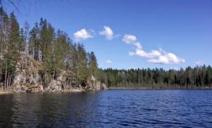
No matter how you walk along this path to the foot of Ai-Petri, along the way you will definitely come across at least one spring, of which there are several, and you will have the opportunity to quench your thirst.
There are also several small lakes and fire ponds in the forest.
The higher you rise, the more majestic and colorful the panoramas of these places will open to you.
Already since Raven rocks your eyes will be surprised by the stunning view of the surrounding area - forest, mountains, sea... below lies Gaspra, Yalta, on the horizon Mount Bear and Gurzuf, and the nearby slopes are overgrown Magobi forest.


But that's not all... The main thing is yet to come! A picturesque, majestic and steep slope of the main Ai-Petri ridge awaits us, attracting the eye, striking and alluring with its seeming inaccessibility.

Our way there is along a well-trodden road.
In the forest, along our path, everything is replete with a variety of spring flowers. The dogwood blossomed.

The abundance of wild primroses is amazing, at this time of year, in mid-March - this is a rarity, usually towards the end of April to the beginning of May, but this year they are reaching for the sun much earlier.
Real forest primroses.

There are many other plants from the family of primroses, but no less beautiful than expensive orchids in supermarkets - of which Scilla bifolia.


Closer to the top it becomes cooler, there is snow in shaded places and even a steep climb does not warm you up at all... It’s cold in winter, steam comes out of your mouth, your fingers get numb.
I pull on my hat, put on my gloves and get active up there!
But as soon as you find yourself in a sunny clearing, it becomes incredibly hot and you want to take off all your insulation quickly -)) In such clearings there is no snow and the delicate inflorescences of the bird's eye peck through the soil.


While admiring this spring variety of colors, you don’t notice how the peak itself is already there. Now it’s quiet here... no one... only the barking of dogs guarding the countless cafes and hotels huddled near top cable car station. Yes, there are several cable car workers who carry out maintenance work.

Now they were busy checking the cables, unwinding huge spools of thick iron threads-ropes that support the well-known trailers.
Under the canopy, several paramilitary guards huddle in the wind and chat.
Having noticed me, they cast a prickly glance at me with suspicious curiosity.
Such views make you feel uncomfortable, and in general, I don’t like civilization on top of Ai-Petri, about 15 years ago this was not allowed in the reserve...
Let's quickly leave here, further to the west... to where only the wind blows, and I...


My path follows Ai-Petri teeth, where once in the Middle Ages there was a Christian temple, past the top, from where a bewitching view opens view of South Bank Crimea..

And if you turn your face to the north, then an endless hilly landscape opens before your eyes. karst field of the Aypetrinsky plateau.
Moving along the edge of the plateau further to the west, now descending, now ascending, you overcome karst faults and sinkholes, gaping with dark, moss-covered unknown voids, which keep in their depths winding dungeons and caves that beckon with their unknowns.


In these karst sinkholes, in the shade, where the snow has just melted, like a dense carpet snowdrops are blooming.
I have never seen such large bushes and such a dense formation as now in the forest near Ai-Petri.


A little higher up the slope, away from the shaded gorges, closer to the light and warmth, on the edge of the karst sinkholes, where there is more sun, it is already blooming in full swing Crimean saffron.
His brother crocus– blooms in October...


Behind Mount Westorn, there is the first descent, counting from Ai-Petrinsky teeth, to the side Alupki, which is called Kuchuk Bogaz or Small Pass– the trail is little traveled, very steep, difficult to climb and not easy to descend.
But our path lies further, to the antenna visible on the horizon - this is a military unit, a radar station and antenna fields.
Before the station there is another descent to the foot Kopek–Bogaz, just as complex as the previous one, partially passing through active loose soil.


Behind the military unit, downgrade again south coast cliffs.
You can go out onto a rocky, forested, rocky outcrop, the beginning of a fairly convenient trail Alupka Bogaz or Shaankai trail.
It goes down and at the foot of the ridge passes a clearly visible ledge, similar to a springboard, called Shaan-Kaya.
On the plateau itself, in its clearings, which are inclined to the south and closed from the north by karst ridges, whole families grow sleep-grass with a bright purple color, which with its fluffy cover resembles shaggy playful kittens. The scientific name of this incomparability is Crimean shot.


It's endemic sleep-grass its popular name.
This plant was especially often used by shamans for their own purposes.
Next to the lumbago, another handsome man, already bright yellow, is basking in the sun - Adonis or Crimean Adonis.


Both plants can be found only in the highlands, where the air is clean and the environment is suitable-)).
You can see it ahead At-Bash(Horse's Head), but to get to it, you need to cross the rocky and inconvenient Lysyaya peak.
When climbing At-Bash, a stunning view of everything opens up Ai-Petri plateau, right up to the beginning of the descent to the inner ridge, on the mountain Bedene-Kyr, which means Quail.
Like giant dinosaur eggs or unprecedented alien dwellings, the giant balls of the military space tracking unit appear white in the distance.

Our path now lies down, still in the same western direction, to the tract Besh-Tekne(translated as five troughs). This is a planned tourist site, where there is a lake and several springs.
There is a lot of water, greenery too, the area is cut by a network of dirt roads, which converge here from the entire plateau into one bunch, so that across At-Bash pass agree on the so-called Jewish trail (road).
It got its name from a Jewish entrepreneur, a timber merchant, who paved this road before the revolution. Its length is more than 5 km. Along it you can go down to the Sevastopol road above Alupka.
This road cannot be called picturesque, since several years ago a large fire raged here, several tens of thousands of hectares of forest burned out. And now this is a rather sad and unpresentable sight.
So it's better to go down through Alupka-Bogaz pass. Well, the route has been completed. Ai-Petri conquered and having made a safe descent, I found myself on south coast.

The length of the route is approximately 18 km, taking into account the descent and ascent from the Sevastopol highway. Basically, this route passes at an altitude of 350 to 1300 meters above sea level. Anyone interested in this route is always ready to help to visit there.